 |
|
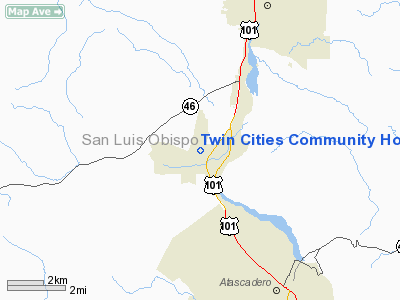
Twin Cities Community Hospital Heliport |
|
|
Location
& QuickFacts
|
FAA
Information Effective: |
2006-09-28 |
|
Airport
Identifier: |
18CA |
|
Longitude/Latitude: |
120-43-09.6180W/35-33-17.8970N
-120.719338/35.554971 (Estimated) |
|
Elevation: |
851 ft / 259.38 m (Estimated) |
|
Land: |
0 acres |
|
From
nearest city: |
1 nautical miles W of Templeton, CA |
|
Location: |
San Luis Obispo County, CA |
|
Magnetic Variation: |
15E (1985) |
Owner
& Manager
|
Ownership: |
Privately owned |
|
Owner: |
Twin Cities Community Hospital |
|
Address: |
1100 Las Tablas Road
Templeton, CA 93465 |
|
Phone
number: |
805-434-2813 |
|
Manager: |
Twin Cities Community Hospital |
|
Address: |
1100 Las Tablas Road
Templeton, CA 93465 |
|
Phone number: |
805-434-3500 |
Airport
Operations and Facilities
|
Airport
Use: |
Private
MEDICAL. |
|
Wind
indicator: |
Yes |
|
Segmented
Circle: |
No |
|
Control
Tower: |
No |
|
Attendance
Schedule: |
ALL/ALL/ALL |
|
Landing
fee charge: |
No |
|
Sectional
chart: |
Los Angeles |
|
Region: |
AWP - Western-Pacific |
|
Boundary
ARTCC: |
ZLA - Los Angeles |
|
Tie-in
FSS: |
HHR - Hawthorne |
|
FSS
on Airport: |
No |
|
FSS
Phone: |
310-970-0102 |
|
FSS
Toll Free: |
1-800-WX-BRIEF |
|
Runway Information
Helipad H1
|
Dimension: |
50 x 50 ft / 15.2 x 15.2 m |
|
Surface: |
CONC, |
|
|
Runway H1 |
Runway |
|
Traffic
Pattern: |
Left |
Left |
|
Radio Navigation
Aids
|
ID |
Type |
Name |
Ch |
Freq |
Var |
Dist |
|
HGT |
NDB |
Hunter Liggett |
|
209.00 |
15E |
33.5 nm |
|
VBG |
TACAN |
Vandenberg |
059Y |
|
15E |
49.9 nm |
|
ROM |
VOR |
Priest |
|
110.00 |
16E |
35.3 nm |
|
GLJ |
VOR |
Guadalupe |
|
111.00 |
16E |
37.5 nm |
|
PRB |
VORTAC |
Paso Robles |
090X |
114.30 |
16E |
8.4 nm |
|
MQO |
VORTAC |
Morro Bay |
071X |
112.40 |
16E |
18.3 nm |
|
AVE |
VORTAC |
Avenal |
118X |
117.10 |
16E |
36.6 nm |
Remarks
-
HELIPAD
USED BY (M.A.S.T.) MILITARY ASSISTANCE FOR SAFETY & TFC.
-
VFR, PVT USE.
Twin Cities Community Hospital Heliport
Address:
San Luis Obispo County, CA
Tel:
805-434-2813,
805-434-3500
Images
and information placed above are from
http://www.airport-data.com/airport/18CA/
We
thank them for the data!
| General
Info |
| Country |
United
States |
| State |
CALIFORNIA
|
| FAA ID |
18CA
|
| Latitude |
35-33-17.897N
|
| Longitude |
120-43-09.618W
|
| Elevation |
851 feet
|
| Near City |
TEMPLETON
|
We don't guarantee the information is fresh and accurate. The data may
be wrong or outdated.
For more up-to-date information please refer to other sources.
|
|


