 |
|
|
|
|
|
Location
& QuickFacts
|
FAA
Information Effective: |
2006-09-28 |
|
Airport
Identifier: |
CA51 |
|
Longitude/Latitude: |
123-25-57.0310W/38-42-16.6830N
-123.432509/38.704634 (Estimated) |
|
Elevation: |
360 ft / 109.73 m (Surveyed) |
|
Land: |
30 acres |
|
From
nearest city: |
3 nautical miles N of The Sea Ranch, CA |
|
Location: |
Sonoma County, CA |
|
Magnetic Variation: |
16E (1985) |
Owner
& Manager
|
Ownership: |
Privately owned |
|
Owner: |
The Sea Ranch Association |
|
Address: |
P.o. Box 16
The Sea Ranch, CA 95497 |
|
Phone
number: |
707-785-2444 |
|
Manager: |
Chief Executive Officer |
|
Address: |
Box 16
The Sea Ranch, CA 95497 |
|
Phone number: |
707-785-2444 |
Airport
Operations and Facilities
|
Airport
Use: |
Private |
|
Wind
indicator: |
Yes |
|
Segmented
Circle: |
Yes |
|
Control
Tower: |
No |
|
Attendance
Schedule: |
UNATNDD |
|
Landing
fee charge: |
No |
|
Sectional
chart: |
San Francisco |
|
Region: |
AWP - Western-Pacific |
|
Boundary ARTCC: |
ZOA - Oakland |
|
Tie-in FSS: |
OAK - Oakland |
|
FSS on Airport: |
No |
|
FSS Phone: |
510-273-6111 |
|
FSS Toll Free: |
1-800-WX-BRIEF |
Airport
Services
|
Airframe
Repair: |
NONE |
|
Power
Plant Repair: |
NONE |
|
Bottled
Oxygen: |
NONE |
|
Bulk
Oxygen: |
NONE |
|
Runway Information
Runway 12/30
|
Dimension: |
2600 x 40 ft / 792.5 x 12.2 m |
|
Surface: |
ASPH, Good Condition |
|
Weight
Limit: |
Single wheel: 12500 lbs. |
|
|
Runway 12 |
Runway 30 |
|
Elevation: |
340.00 ft |
338.00 ft |
|
Traffic
Pattern: |
Right |
Right |
|
Markings: |
Basic, Fair Condition |
Basic, Fair Condition |
|
Displaced
threshold: |
0.00
ft |
300.00 ft |
|
Runway
End Identifier: |
No |
No |
|
Centerline
Lights: |
No |
No |
|
Touchdown
Lights: |
No |
No |
|
Radio Navigation
Aids
|
ID |
Type |
Name |
Ch |
Freq |
Var |
Dist |
|
LOP |
NDB |
Lampson |
|
217.00 |
16E |
31.1 nm |
|
STS |
VOR/DME |
Santa Rosa |
077X |
113.00 |
16E |
31.5 nm |
|
ENI |
VORTAC |
Mendocino |
070X |
112.30 |
16E |
22.2 nm |
|
PYE |
VORTAC |
Point Reyes |
084X |
113.70 |
17E |
46.0 nm |
Remarks
- 200-FOOT
OVERRUN EACH END RWY 12/30.
- FLD
CONDS--TWYS SOME WEATHERING-GOOD; APRON FAIR.
- ALL
AIRCRAFT W/ACCELERATE-STOP DISTANCE EXCESS OF 2300 FEET, PROHIBITED
FROM USING ARPT.
- RWYS
12/30 LEFT TURN AFTER TKOF.
Based Aircraft
|
Aircraft
based on field: |
9 |
|
Single
Engine Airplanes: |
8 |
|
Multi
Engine Airplanes: |
1 |
Operational Statistics
|
Aircraft
Operations: |
174/Week |
|
General
Aviation Local: |
33.3% |
|
General
Aviation Itinerant: |
66.7% |
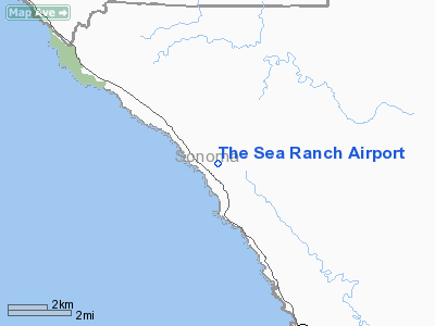
The Sea Ranch Airport
Address:
Sonoma County, CA
Tel:
707-785-2444
Images
and information placed above are from
http://www.airport-data.com/airport/CA51/
We
thank them for the data!
| General
Info |
| Country |
United
States |
| State |
CALIFORNIA
|
| FAA ID |
CA51
|
| Latitude |
38-42-16.683N
|
| Longitude |
123-25-57.031W
|
| Elevation |
360 feet
|
| Near City |
THE SEA
RANCH |
We don't guarantee the information is fresh and accurate. The data may
be wrong or outdated.
For more up-to-date information please refer to other sources.
|
|


