|
|
Tehachapi Municipal Airport |
| Tehachapi Municipal Airport |
 |
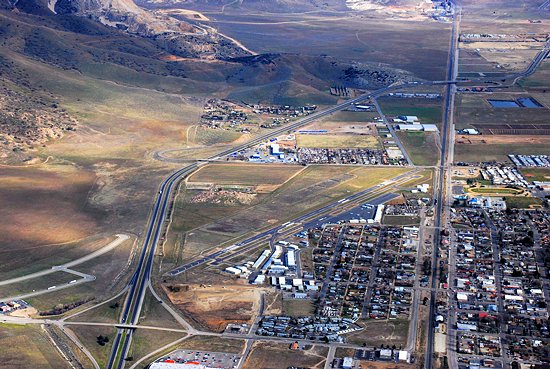
| Aerial: KTSP Airport area |
| IATA: TSP – ICAO: KTSP – FAA LID: TSP |
| Summary |
| Airport type |
Public |
| Operator |
City of Tehachapi |
| Location |
Tehachapi, California |
| Elevation AMSL |
4,001 ft / 1,219.5 m |
| Coordinates |
35°08′06″N 118°26′21″W / 35.135°N 118.43917°W / 35.135; -118.43917Coordinates: 35°08′06″N 118°26′21″W / 35.135°N 118.43917°W / 35.135; -118.43917 |
| Website |
http://www.tehachapicityhall.com/index.asp?nid=26 |
| Runways |
| Direction |
Length |
Surface |
| ft |
m |
| 11/29 |
4,031 |
1,229 |
Asphalt |
Tehachapi Municipal Airport (IATA: TSP, ICAO: KTSP, FAA LID: TSP) is a public airport located in Tehachapi, serving Kern County, California, USA. This general aviation airport covers 264 acres (107 ha) and has one runway.
The airport was established in 1929 originally to support an air mail route between Tehachapi and Bakersfield. In 1952 after a magnitude 7.7 earthquake isolated Tehachapi from access by roads or rail, the airport served as the destination for an emergency relief airlift for several weeks. There are currently hangars and an industrial park on the south side of the airport. The city plans to begin an expansion of the airport to include a taxiway and hangars on the north side in 2009.
The above content comes from Wikipedia and is published under free licenses – click here to read more.
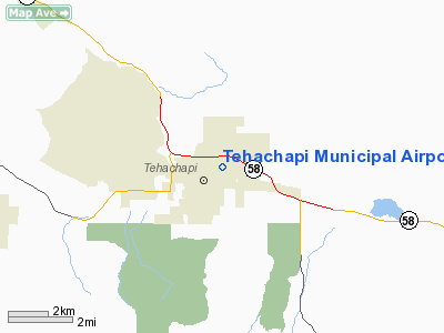
Location & QuickFacts
|
FAA
Information Effective: |
2006-09-28 |
|
Airport Identifier: |
TSP |
|
Longitude/Latitude: |
118-26-21.2000W/35-08-06.0000N
-118.439222/35.135000 (Estimated) |
|
Elevation: |
4001
ft / 1219.50 m (Surveyed) |
|
Land: |
264
acres |
|
From nearest
city: |
0
nautical miles NE of Tehachapi, CA |
|
Location: |
Kern
County, CA |
|
Magnetic
Variation: |
14E
(1985) |
Owner & Manager
|
Ownership: |
Publicly
owned |
|
Owner: |
City
Of Tehachapi |
|
Address: |
115
South Robinson
Tehachapi, CA 93581 |
|
Phone number: |
661-822-2200 |
|
Manager: |
David
Zweigle |
|
Address: |
115
South Robinson Street
Tehachapi, CA 93561 |
|
Phone
number: |
661-822-2200 |
Airport
Operations and Facilities
|
Airport
Use: |
Open to
public |
|
Wind indicator: |
Yes |
|
Segmented
Circle: |
Yes |
|
Control Tower: |
No |
|
Attendance
Schedule: |
ALL/ALL/0800-1700
CLSD HOLIDAYS. FOR AFTER HRS ARPT ATTENDANCE CALL (661)
823-1396. |
|
Lighting
Schedule: |
DUSK-DAWN
ACTVT HIRL RY 11/29 - CTAF. |
|
Beacon Color: |
Clear-Green (lighted land airport) |
|
Landing fee
charge: |
No |
|
Sectional
chart: |
Los
Angeles |
|
Region: |
AWP
- Western-Pacific |
|
Traffic Pattern
Alt: |
1000
ft |
|
Boundary
ARTCC: |
ZLA
- Los Angeles |
|
Tie-in FSS: |
RIU
- Rancho Murieta |
|
FSS on Airport: |
No |
|
FSS Phone: |
916-354-0161 |
|
FSS Toll
Free: |
1-800-WX-BRIEF |
|
NOTAMs Facility: |
RIU
(NOTAM-d service avaliable) |
|
Federal
Agreements: |
NGY |
Airport
Communications
|
CTAF: |
123.000 |
|
Unicom: |
123.000
|
Airport Services
|
Fuel
available: |
100LL
FUEL 24 HRS CREDIT CARD. |
|
Airframe
Repair: |
MAJOR |
|
Power
Plant Repair: |
MAJOR |
|
Bulk Oxygen: |
NONE |
|
Runway Information
Runway 11/29
|
Dimension: |
4031 x 75 ft / 1228.6
x 22.9 m |
|
Surface: |
ASPH,
Good Condition |
|
Edge Lights: |
High |
|
|
Runway 11 |
Runway 29 |
|
Longitude: |
118-26-41.2356W |
118-26-01.2016W |
|
Latitude: |
35-08-17.2236N |
35-07-54.7029N |
|
Elevation: |
3958.00 ft |
4001.00 ft |
|
Alignment: |
124 |
127 |
|
Traffic Pattern: |
Right |
Left |
|
Markings: |
Basic, Good Condition |
Basic, Good Condition |
|
Crossing Height: |
0.00
ft |
15.00
ft |
|
Displaced threshold: |
285.00 ft |
375.00 ft |
|
VASI: |
|
2-light PAPI on left side |
|
Visual Glide
Angle: |
0.00� |
3.50� |
|
Runway End
Identifier: |
No |
No |
|
Centerline
Lights: |
No |
No |
|
Touchdown Lights: |
No |
No |
|
Obstruction: |
276
ft hill, 4800.0 ft from runway, 16:1 slope to clear
APCH RATIO TO DSPLCD THR 18:1. |
31
ft poles, 450.0 ft from runway, 100 ft right of centerline,
8:1 slope to clear
APCH RATIO TO DSPLCD THR 31:1. |
|
Radio Navigation Aids
|
ID |
Type |
Name |
Ch |
Freq |
Var |
Dist |
|
GWF |
NDB |
Gen
William J Fox |
|
282.00 |
15E |
26.2
nm |
|
NID |
TACAN |
China
Lake |
053X |
|
16E |
49.5
nm |
|
LHS |
VORTAC |
Lake
Hughes |
021X |
108.40 |
15E |
28.0
nm |
|
GMN |
VORTAC |
Gorman |
108X |
116.10 |
16E |
28.8
nm |
|
PMD |
VORTAC |
Palmdale |
092X |
114.50 |
15E |
35.5
nm |
|
EDW |
VORTAC |
Edwards |
111X |
116.40 |
15E |
36.0
nm |
|
EHF |
VORTAC |
Shafter |
101X |
115.40 |
14E |
38.5
nm |
|
BFL |
VOT |
Bakersfield |
|
111.20 |
|
34.5
nm |
Remarks
- LGTD
OBSTN/MOUNTAIN/1 MI WEST OF ARPT (4279' MSL).
- ESTABD
PRIOR TO 1959.
Based Aircraft
|
Aircraft
based on field: |
96 |
|
Single
Engine Airplanes: |
90 |
|
Multi
Engine Airplanes: |
4 |
|
Jet Engine
Airplanes: |
1 |
|
Ultralights: |
1 |
Operational Statistics
|
Aircraft
Operations: |
212/Week |
|
General
Aviation Local: |
40.9% |
|
General
Aviation Itinerant: |
59.1% |
Tehachapi Municipal Airport
Address: Kern
County, CA
Tel:
661-822-2200
Images
and information placed above are from
http://www.airport-data.com/airport/TSP/
We
thank them for the data!
| General
Info |
| Country |
United
States |
| State |
CALIFORNIA
|
| FAA ID |
TSP
|
| Latitude |
35-08-05.900N
|
| Longitude |
118-26-21.300W
|
| Elevation |
3998 feet
|
| Near City |
TEHACHAPI
|
We don't guarantee the information is fresh and accurate. The data may
be wrong or outdated.
For more up-to-date information please refer to other sources.
|
|