 |
|
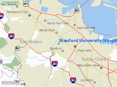
Stanford University Hospital Center Heliport |
|
|
Location
& QuickFacts
|
FAA
Information Effective: |
2006-09-28 |
|
Airport
Identifier: |
15CA |
|
Longitude/Latitude: |
122-10-29.8730W/37-26-07.7800N
-122.174965/37.435494 (Estimated) |
|
Elevation: |
84 ft / 25.60 m (Estimated) |
|
Land: |
0 acres |
|
From
nearest city: |
0 nautical miles W of Palo Alto, CA |
|
Location: |
Santa Clara County, CA |
|
Magnetic Variation: |
16E (1985) |
Owner
& Manager
|
Ownership: |
Privately owned |
|
Owner: |
Stanford Univ Hosp Center |
|
Address: |
300 Pasteur Drive
Palo Alto, CA 94305 |
|
Phone
number: |
415-725-5063 |
|
Manager: |
Susan Lockman |
|
Address: |
300 Pasteur Dr Rm H1249
Palo Alto, CA 94305 |
|
Phone number: |
415-723-5578 |
Airport
Operations and Facilities
|
Airport
Use: |
Private
MEDICAL. |
|
Wind
indicator: |
Yes |
|
Segmented
Circle: |
No |
|
Control
Tower: |
No |
|
Attendance
Schedule: |
UNATNDD |
|
Lighting
Schedule: |
PHONE REQ
FOR ARPT BCN CALL 415-725-5063 |
|
Beacon
Color: |
Clear-Green-Yellow (heliport) |
|
Landing
fee charge: |
No |
|
Sectional
chart: |
San Francisco |
|
Region: |
AWP - Western-Pacific |
|
Boundary
ARTCC: |
ZOA - Oakland |
|
Tie-in
FSS: |
OAK - Oakland |
|
FSS
on Airport: |
No |
|
FSS
Phone: |
510-273-6111 |
|
FSS
Toll Free: |
1-800-WX-BRIEF |
|
Runway Information
Helipad H1
|
Dimension: |
100 x 100 ft / 30.5 x 30.5 m |
|
Surface: |
ASPH, |
|
|
Runway H1 |
Runway |
|
Traffic
Pattern: |
Left |
Left |
|
Radio Navigation
Aids
|
ID |
Type |
Name |
Ch |
Freq |
Var |
Dist |
|
LV |
NDB |
Reiga |
|
374.00 |
16E |
28.0 nm |
|
PDG |
NDB |
Pajar |
|
327.00 |
17E |
36.0 nm |
|
TCY |
NDB |
Tracy |
|
203.00 |
15E |
38.1 nm |
|
NUQ |
TACAN |
Moffett |
123X |
|
17E |
5.6 nm |
|
SUU |
TACAN |
Travis |
113X |
|
17E |
49.9 nm |
|
SJC |
VOR/DME |
San Jose |
088X |
114.10 |
16E |
11.6 nm |
|
SFO |
VOR/DME |
San Francisco |
105X |
115.80 |
17E |
14.6 nm |
|
CCR |
VOR/DME |
Concord |
117X |
117.00 |
17E |
37.1 nm |
|
OSI |
VORTAC |
Woodside |
086X |
113.90 |
17E |
5.7 nm |
|
OAK |
VORTAC |
Oakland |
115X |
116.80 |
17E |
17.6 nm |
|
SAU |
VORTAC |
Sausalito |
109X |
116.20 |
17E |
30.2 nm |
|
SGD |
VORTAC |
Scaggs Island |
058X |
112.10 |
17E |
45.7 nm |
|
SFO |
VOT |
San Francisco Intl |
|
111.00 |
|
14.6 nm |
Remarks
- PROVIDED
APCH/DEP PATHS ARE ESTABLISHED TO THE NORTH & WEST.
Based Aircraft
|
Aircraft
based on field: |
1 |
|
Helicopters: |
1 |
Stanford University Hospital Center Heliport
Address:
Santa Clara County, CA
Tel:
415-725-5063,
415-723-5578
Images
and information placed above are from
http://www.airport-data.com/airport/15CA/
We
thank them for the data!
| General
Info |
| Country |
United
States |
| State |
CALIFORNIA
|
| FAA ID |
15CA
|
| Latitude |
37-26-07.780N
|
| Longitude |
122-10-29.873W
|
| Elevation |
84 feet
|
| Near City |
PALO ALTO |
We don't guarantee the information is fresh and accurate. The data may
be wrong or outdated.
For more up-to-date information please refer to other sources.
|
|


