 |
|
St John's Regional Medical Center Heliport |
|
|
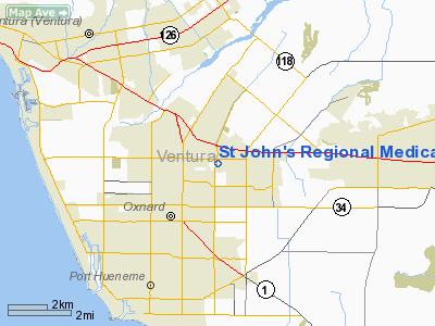
Location
& QuickFacts
|
FAA
Information Effective: |
2006-09-28 |
|
Airport
Identifier: |
2CL6 |
|
Longitude/Latitude: |
119-09-28.3830W/34-13-00.0170N
-119.157884/34.216671 (Estimated) |
|
Elevation: |
76 ft / 23.16 m (Estimated) |
|
Land: |
47 acres |
|
From
nearest city: |
2 nautical miles N of Oxnard, CA |
|
Location: |
Ventura County, CA |
|
Magnetic Variation: |
14E (1990) |
Owner
& Manager
|
Ownership: |
Privately owned |
|
Owner: |
St Johns Regional Medical Ctr |
|
Address: |
1600 North Rose Ave
Oxnard, CA 93030 |
|
Phone
number: |
805-988-2500 |
|
Manager: |
Bonny Friedrich |
|
Address: |
1600 North Rose Ave
Oxnard, CA 93030 |
|
Phone number: |
805-988-2866 |
Airport
Operations and Facilities
|
Airport
Use: |
Private
MEDICAL USE. |
|
Wind
indicator: |
Yes |
|
Segmented
Circle: |
No |
|
Control
Tower: |
No |
|
Attendance
Schedule: |
ALL/ALL/ALL |
|
Lighting
Schedule: |
DUSK-DAWN |
|
Landing
fee charge: |
Yes |
|
Sectional
chart: |
Los Angeles |
|
Region: |
AWP - Western-Pacific |
|
Boundary
ARTCC: |
ZLA - Los Angeles |
|
Tie-in
FSS: |
HHR - Hawthorne |
|
FSS
on Airport: |
No |
|
FSS
Phone: |
310-970-0102 |
|
FSS
Toll Free: |
1-800-WX-BRIEF |
|
Runway Information
Helipad H1
|
Dimension: |
60 x 60 ft / 18.3 x 18.3 m |
|
Surface: |
CONC, |
|
|
Runway H1 |
Runway |
|
Traffic
Pattern: |
Left |
Left |
|
Radio Navigation
Aids
|
ID |
Type |
Name |
Ch |
Freq |
Var |
Dist |
|
PAI |
NDB |
Pacoima |
|
370.00 |
15E |
37.1 nm |
|
CPM |
NDB |
Compton |
|
378.00 |
15E |
49.4 nm |
|
NTD |
TACAN |
Point Mugu |
043X |
|
15E |
5.9 nm |
|
CMA |
VOR/DME |
Camarillo |
105X |
115.80 |
15E |
3.2 nm |
|
VTU |
VOR/DME |
Ventura |
019X |
108.20 |
15E |
8.1 nm |
|
VNY |
VOR/DME |
Van Nuys |
078X |
113.10 |
15E |
33.1 nm |
|
SMO |
VOR/DME |
Santa Monica |
045X |
110.80 |
15E |
37.0 nm |
|
FIM |
VORTAC |
Fillmore |
072X |
112.50 |
15E |
16.1 nm |
|
RZS |
VORTAC |
San Marcus |
096X |
114.90 |
14E |
35.1 nm |
|
GMN |
VORTAC |
Gorman |
108X |
116.10 |
16E |
38.2 nm |
|
LAX |
VORTAC |
Los Angeles |
083X |
113.60 |
15E |
40.0 nm |
|
LHS |
VORTAC |
Lake Hughes |
021X |
108.40 |
15E |
40.2 nm |
|
LAX |
VOT |
San Pedro Hill |
|
113.90 |
|
49.8 nm |
Remarks
- (E111-1)
ATCT MGR SHALL FORWARD LETTER OF AGREEMENT TO AWP-530 FOR REVIEW.
- PROVIDED
VFR PVT USE; FOR USE DUSK-DAWN OPNS HELIPORT LIGHTING SHOULD BE INSTALLED
IN ACCORDANCE WITH FAA AC 150/5390-2 CHAPTER 2 & 3; A LETTER OF
AGREEMENT BETWEEN ST JOHNS REGIONAL MEDICAL CENTER & OXNARD ATCT
AT LEAST 3 MONTHS PRIOR TO COMMENCING FLT OPNS.
St John's Regional Medical Center Heliport
Address:
Ventura County, CA
Tel:
805-988-2500,
805-988-2866
Images
and information placed above are from
http://www.airport-data.com/airport/2CL6/
We
thank them for the data!
| General
Info |
| Country |
United
States |
| State |
CALIFORNIA
|
| FAA ID |
2CL6
|
| Latitude |
34-13-00.017N
|
| Longitude |
119-09-28.383W
|
| Elevation |
76 feet
|
| Near City |
OXNARD
|
We don't guarantee the information is fresh and accurate. The data may
be wrong or outdated.
For more up-to-date information please refer to other sources.
|
|


