 |
|
South County Arpt Of Santa Clara County Airport |
South County Airport
of Santa Clara County |
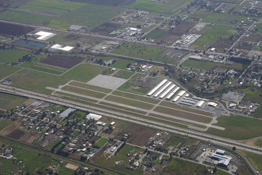 |
| View from northeast |
| IATA: none – ICAO: none – FAA LID: E16 |
| Summary |
| Airport type |
Public |
| Operator |
County of Santa Clara |
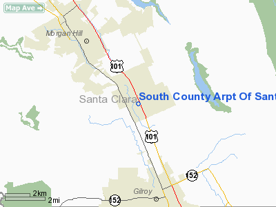
| Location |
San Martin, California |
| Elevation AMSL |
281 ft / 85.6 m |
| Coordinates |
37°04′54″N 121°35′48″W / 37.08167°N 121.59667°W / 37.08167; -121.59667Coordinates: 37°04′54″N 121°35′48″W / 37.08167°N 121.59667°W / 37.08167; -121.59667 |
| Runways |
| Direction |
Length |
Surface |
| ft |
m |
| 14/32 |
3,100 |
945 |
Asphalt |
South County Airport of Santa Clara County, colloquially South County Airport, (FAA LID: E16) (formerly Q99) is a public airport located one mile (1.6 km) east of San Martin, serving Santa Clara County, California, U.S.A. This general aviation airport covers 179 acres (72 ha) and has one runway. A self-service fueling facility offers 100LL aviation gasoline continuously. Jet-A fuel is available from a full-service truck during FBO operating hours, and major airframe and powerplant service are available.
The Wings of History Air Museum is located adjacent to the airport.
The above content comes from Wikipedia and is published under free licenses – click here to read more.
Location
& QuickFacts
|
FAA
Information Effective: |
2006-09-28 |
|
Airport
Identifier: |
E16 |
|
Longitude/Latitude: |
121-35-48.5000W/37-04-53.7100N
-121.596806/37.081586 (Estimated) |
|
Elevation: |
281 ft / 85.65 m (Estimated) |
|
Land: |
179 acres |
|
From
nearest city: |
1 nautical miles E of San Martin, CA |
|
Location: |
Santa Clara County, CA |
|
Magnetic Variation: |
15E (2000) |
Owner
& Manager
|
Ownership: |
Publicly owned |
|
Owner: |
County Of Santa Clara |
|
Address: |
2500 Cunningham Ave.
San Jose, CA 95148 |
|
Phone
number: |
408-929-1060
CARL HONAKER, DIRECTOR OF AIRPORTS. |
|
Manager: |
Carl Honaker
LARRY FELDMAN AMGR. CARL HONAKER - DIRECTOR OF AIRPORTS
(408) 929-1060. |
|
Address: |
2500 Cunningham Avenue
San Jose, CA 95148 |
|
Phone number: |
408-272-0160 |
Airport
Operations and Facilities
|
Airport
Use: |
Open to public |
|
Wind
indicator: |
Yes |
|
Segmented
Circle: |
Yes |
|
Control
Tower: |
No |
|
Attendance
Schedule: |
ALL/ALL/SR-SS |
|
Lighting
Schedule: |
DUSK-DAWN
ACTVT MIRL RY 14/32 AND PAPI RYS 14 & 32 - CTAF. |
|
Beacon
Color: |
Clear-Green (lighted land airport) |
|
Landing
fee charge: |
No |
|
Sectional
chart: |
San Francisco |
|
Region: |
AWP - Western-Pacific |
|
Traffic
Pattern Alt: |
1000 ft |
|
Boundary
ARTCC: |
ZOA - Oakland |
|
Tie-in
FSS: |
OAK - Oakland |
|
FSS
on Airport: |
No |
|
FSS
Phone: |
510-273-6111 |
|
FSS
Toll Free: |
1-800-WX-BRIEF |
|
NOTAMs
Facility: |
OAK (NOTAM-d service avaliable) |
|
Federal Agreements: |
NGY |
Airport
Communications
|
CTAF: |
122.700 |
|
Unicom: |
122.700 |
Airport
Services
|
Fuel
available: |
100LL
SELF-FUELING FACILITY AVAILABLE 24/7. |
|
Airframe
Repair: |
MAJOR |
|
Power
Plant Repair: |
MAJOR |
|
Bottled
Oxygen: |
NONE |
|
Bulk
Oxygen: |
NONE |
|
Runway Information
Runway 14/32
|
Dimension: |
3100 x 75 ft / 944.9 x 22.9 m |
|
Surface: |
ASPH, Good Condition |
|
Weight
Limit: |
Single wheel: 12500 lbs. |
|
Edge
Lights: |
Medium |
|
|
Runway 14 |
Runway 32 |
|
Longitude: |
121-35-56.2100W |
121-35-40.7800W |
|
Latitude: |
37-05-07.7300N |
37-04-39.6800N |
|
Elevation: |
281.00 ft |
271.00 ft |
|
Alignment: |
127 |
127 |
|
Traffic
Pattern: |
Left |
Right |
|
Markings: |
Basic, Good Condition |
Basic, Good Condition |
|
VASI: |
2-light PAPI on left side |
2-light PAPI on left side |
|
Visual
Glide Angle: |
4.00� |
4.00� |
|
Runway
End Identifier: |
No |
No |
|
Centerline
Lights: |
No |
No |
|
Touchdown
Lights: |
No |
No |
|
Obstruction: |
41 ft pole, 1100.0 ft from runway, 200 ft right
of centerline, 21:1 slope to clear |
, 50:1 slope to clear |
|
Radio Navigation
Aids
|
ID |
Type |
Name |
Ch |
Freq |
Var |
Dist |
|
PDG |
NDB |
Pajar |
|
327.00 |
17E |
14.3 nm |
|
UAD |
NDB |
Chualar |
|
263.00 |
16E |
36.0 nm |
|
LV |
NDB |
Reiga |
|
374.00 |
16E |
36.9 nm |
|
TCY |
NDB |
Tracy |
|
203.00 |
15E |
37.4 nm |
|
NUQ |
TACAN |
Moffett |
123X |
|
17E |
30.5 nm |
|
SJC |
VOR/DME |
San Jose |
088X |
114.10 |
16E |
24.2 nm |
|
MOD |
VOR/DME |
Modesto |
093X |
114.60 |
17E |
44.8 nm |
|
SFO |
VOR/DME |
San Francisco |
105X |
115.80 |
17E |
49.2 nm |
|
SNS |
VORTAC |
Salinas |
120X |
117.30 |
17E |
25.1 nm |
|
OSI |
VORTAC |
Woodside |
086X |
113.90 |
17E |
37.7 nm |
|
PXN |
VORTAC |
Panoche |
073X |
112.60 |
16E |
45.1 nm |
|
OAK |
VORTAC |
Oakland |
115X |
116.80 |
17E |
48.9 nm |
|
ECA |
VORTAC |
Manteca |
107X |
116.00 |
17E |
49.6 nm |
|
SFO |
VOT |
San Francisco Intl |
|
111.00 |
|
49.3 nm |
Remarks
- NO
CROSSWIND TURNS BELOW 1300' MSL; DEPARTURES CLIMB TO 2000' MSL.
- ARPT
CLOSED TO PURE JET ACFT & SURPLUS MILITARY ACFT EXCEPT THOSE MEETING
FAR 36 NOISE CRITERIA.
- APCHG
ACFT FLY DOWN WIND LEGS EAST OF FREEWAY.
- NO
TOUCH & GO LANDINGS BETWEEN 1900-0700.
- LFT
TFC PATTERN RWY 14 TO AVOID FLYING OVER SCHOOL & RGT TFC PATTERN
RWY 32 TO AVOID FLYING OVER SCHOOL.
Based Aircraft
|
Aircraft
based on field: |
90 |
|
Single
Engine Airplanes: |
80 |
|
Multi
Engine Airplanes: |
9 |
|
Helicopters: |
1 |
Operational Statistics
|
Aircraft
Operations: |
140/Day |
|
General
Aviation Local: |
63.3% |
|
General
Aviation Itinerant: |
36.7% |
South County Arpt Of Santa Clara County
Airport
Address:
Santa Clara County, CA
Tel:
408-929-1060, 408-272-0160
Images
and information placed above are from
http://www.airport-data.com/airport/E16/
We
thank them for the data!
| General
Info |
| Country |
United
States |
| State |
CALIFORNIA
|
| FAA ID |
E16
|
| Latitude |
37.081586
37� 04' 53.71" N |
| Longitude |
-121.596806
121� 35' 48.50" W |
| Elevation |
281 feet
86 meters |
| Magnetic
Variation |
014� E
(01/06) |
| Beacon |
Yes
|
| Operating
Agency |
U.S.CIVIL
AIRPORT WHEREIN PERMIT COVERS USE BY TRANSIT MILITARY AIRCRAFT
|
| Daylight
Savings Time |
First
Sunday in April at 0200 to last Sunday in October at 0200 local time
(Exception Arizona and that portion of Indiana in the Eastern Time
Zone) |
We don't guarantee the information is fresh and accurate. The data may
be wrong or outdated.
For more up-to-date information please refer to other sources.
|
|


