 |
|
|
|
Location
& QuickFacts
|
FAA
Information Effective: |
2006-09-28 |
|
Airport
Identifier: |
27CL |
|
Longitude/Latitude: |
121-34-21.8500W/38-44-49.6470N
-121.572736/38.747124 (Estimated) |
|
Elevation: |
20 ft / 6.10 m (Estimated) |
|
Land: |
0 acres |
|
From
nearest city: |
7 nautical miles SW of Pleasant Grove, CA |
|
Location: |
Sutter County, CA |
|
Magnetic Variation: |
16E (1985) |
Owner
& Manager
|
Ownership: |
Privately owned |
|
Owner: |
J. T. Sopwith |
|
Address: |
4850 Riego Rd
Sacramento, CA 95836 |
|
Phone number: |
916-929-7657 |
|
Manager: |
J. T. Sopwith |
|
Address: |
4850 Riego Rd
Sacramento, CA 95836 |
|
Phone number: |
916-929-7657 |
Airport
Operations and Facilities
|
Airport Use: |
Private |
|
Wind indicator: |
Yes |
|
Segmented Circle: |
No |
|
Control Tower: |
No |
|
Attendance Schedule: |
UNATNDD |
|
Landing fee charge: |
No |
|
Sectional chart: |
San Francisco |
|
Region: |
AWP - Western-Pacific |
|
Boundary ARTCC: |
ZOA - Oakland |
|
Tie-in FSS: |
RIU - Rancho Murieta |
|
FSS on Airport: |
No |
|
FSS Phone: |
916-354-0161 |
|
FSS Toll Free: |
1-800-WX-BRIEF |
Airport
Services
|
Airframe
Repair: |
NONE |
|
Power
Plant Repair: |
NONE |
|
Runway Information
Runway 16/34
|
Dimension: |
2000 x 60 ft / 609.6 x 18.3 m |
|
Surface: |
ASPH-TRTD,
< OILED IS 900? SOUTH ASPHALT,
1100?
END NORTH 34 16> |
|
|
Runway 16 |
Runway 34 |
|
Traffic
Pattern: |
Left |
Right |
|
Radio Navigation
Aids
|
ID |
Type |
Name |
Ch |
Freq |
Var |
Dist |
|
MY |
NDB |
Halow |
|
222.00 |
16E |
25.4 nm |
|
OVE |
NDB |
Oroville |
|
212.00 |
16E |
45.0 nm |
|
BAB |
TACAN |
Beale |
023X |
|
16E |
24.1 nm |
|
SUU |
TACAN |
Travis |
113X |
|
17E |
34.9 nm |
|
TZZ |
VOR |
Travis |
|
116.40 |
17E |
26.7 nm |
|
MCC |
VOR/DME |
Mc Clellan |
029X |
109.20 |
17E |
9.2 nm |
|
MYV |
VOR/DME |
Marysville |
045X |
110.80 |
16E |
21.1 nm |
|
HNW |
VOR/DME |
Hangtown |
102X |
115.50 |
17E |
38.6 nm |
|
CCR |
VOR/DME |
Concord |
117X |
117.00 |
17E |
47.7 nm |
|
SAC |
VORTAC |
Sacramento |
099X |
115.20 |
17E |
18.3 nm |
|
ILA |
VORTAC |
Williams |
091X |
114.40 |
18E |
28.8 nm |
|
MXW |
VORTAC |
Maxwell |
037X |
110.00 |
18E |
45.8 nm |
|
LIN |
VORTAC |
Linden |
095X |
114.80 |
17E |
48.5 nm |
|
SMF |
VOT |
Sacramento Metropolitan |
|
111.40 |
|
3.5 nm |
|
SAC |
VOT |
Sacramento Executive |
|
111.40 |
|
14.5 nm |
Remarks
- PATTERN
600' AGL. RGT PATTERN TO N. 2-WAY RDO WITH SAC METRO ATCT WHEN SAC METRO
16L-34R CONSTRD.
Based Aircraft
|
Aircraft
based on field: |
1 |
|
Single
Engine Airplanes: |
1 |
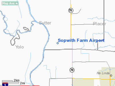
Sopwith Farm Airport
Address:
Sutter County, CA
Tel:
916-929-7657
Images
and information placed above are from
http://www.airport-data.com/airport/27CL/
We
thank them for the data!
| General
Info |
| Country |
United
States |
| State |
CALIFORNIA
|
| FAA ID |
27CL
|
| Latitude |
38-44-49.647N
|
| Longitude |
121-34-21.850W
|
| Elevation |
20 feet
|
| Near City |
PLEASANT
GROVE |
We don't guarantee the information is fresh and accurate. The data may
be wrong or outdated.
For more up-to-date information please refer to other sources.
|
|


