 |
|
| Sonoma Skypark |
| IATA: none – ICAO: none – FAA LID: 0Q9 |
| Summary |
| Airport type |
Public-use |
| Owner |
Sonoma Skypark, Inc. |
| Serves |
Sonoma, California |
| Elevation AMSL |
20 ft / 6 m |
| Coordinates |
38°15′27″N 122°26′03″W / 38.2575°N 122.43417°W / 38.2575; -122.43417Coordinates: 38°15′27″N 122°26′03″W / 38.2575°N 122.43417°W / 38.2575; -122.43417 |
| Website |
www.sonomaskypark.com |
| Runways |
| Direction |
Length |
Surface |
| ft |
m |
| 8/26 |
2,090 |
637 |
Asphalt |
| Statistics (1996) |
| Aircraft operations |
10,100 |
| Based aircraft |
60 |
| Source: Federal Aviation Administration
Runway length shown is between displaced threshold marks, though indicated as a 2480 foot (756 m) runway.
|
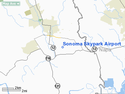
Sonoma Skypark (FAA LID: 0Q9) is a public-use airport located three miles (5 km) southeast of the central business district of Sonoma, a city in Sonoma County, California, United States. It is privately owned by Sonoma Skypark, Inc.
The airport is located 2.3 nautical miles (4.3 km) south of central business district of Sonoma (2.7 mi, 4.3 km) and 28.9 nmi (53.5 km) north of San Francisco city center (33.2 mi, 53.5 km).
It opened on January 3, 1965 in Vineburg, Sonoma, California, USA.
Open to public use for light aircraft, the airfield offers various services, such as computer-based and in-flight training and self-serve 100LL Aviation Fuel.
The hangars shelter many antique and classic aircraft, including a 1947 Luscombe 8E (Silvaire), a 1941 Interstate S-1A Cadet, a Briegleb BG 7 glider, and a 1946 Aeronca Champion.
The airfield hosts a monthly Young Eagles Program, launched by the EAA in 1992 to give young people (from 8 to 17) an opportunity to go flying in a general aviation airplane. Young eagles flights take place on the second Sunday of every month from 9am to Noon. Facilities and aircraft
Sonoma Skypark covers an area of 30 acres (12 ha) and contains one runway designated 8/26 with a 2,480 x 40 ft (756 x 12 m) asphalt pavement. For the 12-month period ending November 6, 1996, the airport had 10,100 general aviation aircraft operations, an average of 27 per day. At that time there were 60 aircraft based at this airport: 95% single-engine and 5% multi-engine.
The above content comes from Wikipedia and is published under free licenses – click here to read more.
Location
& QuickFacts
|
FAA
Information Effective: |
2006-09-28 |
|
Airport
Identifier: |
0Q9 |
|
Longitude/Latitude: |
122-26-03.9230W/38-15-27.6960N
-122.434423/38.257693 (Estimated) |
|
Elevation: |
20 ft / 6.10 m (Estimated) |
|
Land: |
30 acres |
|
From
nearest city: |
3 nautical miles SE of Sonoma, CA |
|
Location: |
Sonoma County, CA |
|
Magnetic Variation: |
16E (1985) |
Owner
& Manager
|
Ownership: |
Privately owned |
|
Owner: |
Sonoma Skypark, Inc. |
|
Address: |
21870 8th Street East
Sonoma, CA 95476 |
|
Phone
number: |
707-996-2100 |
|
Manager: |
Charles Hadley |
|
Address: |
21870 8th Street East
Sonoma, CA 95476 |
|
Phone number: |
707-996-2100 |
Airport
Operations and Facilities
|
Airport
Use: |
Open to public |
|
Wind
indicator: |
Yes |
|
Segmented
Circle: |
Yes |
|
Control
Tower: |
No |
|
Attendance
Schedule: |
ALL/ALL/0900-1700 |
|
Landing
fee charge: |
No |
|
Sectional
chart: |
San Francisco |
|
Region: |
AWP - Western-Pacific |
|
Traffic
Pattern Alt: |
1000 ft |
|
Boundary
ARTCC: |
ZOA - Oakland |
|
Tie-in
FSS: |
OAK - Oakland |
|
FSS
on Airport: |
No |
|
FSS
Phone: |
510-273-6111 |
|
FSS
Toll Free: |
1-800-WX-BRIEF |
|
NOTAMs
Facility: |
OAK (NOTAM-d service avaliable) |
Airport
Communications
|
CTAF: |
122.800 |
|
Unicom: |
122.800 |
Airport
Services
|
Fuel
available: |
100LLMOGAS |
|
Airframe
Repair: |
MAJOR |
|
Power
Plant Repair: |
MAJOR |
|
Bottled
Oxygen: |
NONE |
|
Bulk
Oxygen: |
NONE |
|
Runway Information
Runway 08/26
|
Dimension: |
2480 x 40 ft / 755.9 x 12.2 m |
|
Surface: |
ASPH, Fair Condition |
|
Weight
Limit: |
Single wheel: 8000 lbs. |
|
|
Runway 08 |
Runway 26 |
|
Traffic
Pattern: |
Right |
Left |
|
Markings: |
Basic, Good Condition |
Basic, Good Condition |
|
Displaced
threshold: |
140.00 ft |
237.00 ft |
|
Runway
End Identifier: |
No |
No |
|
Centerline
Lights: |
No |
No |
|
Touchdown
Lights: |
No |
No |
|
Obstruction: |
60 ft trees, 1400.0 ft from runway, 173 ft
right of centerline, 20:1 slope to clear
APCH RATIO TO DSPLCD THLD 22:1. |
30 ft tree, 363.0 ft from runway, 150 ft right
of centerline, 5:1 slope to clear
APCH RATIO TO DSPLCD THLD 20:1.
4
FT BRUSH 200 FT FM THLD 75 FT RIGHT. |
|
Radio Navigation
Aids
|
ID |
Type |
Name |
Ch |
Freq |
Var |
Dist |
|
LOP |
NDB |
Lampson |
|
217.00 |
16E |
49.1 nm |
|
LV |
NDB |
Reiga |
|
374.00 |
16E |
49.2 nm |
|
SUU |
TACAN |
Travis |
113X |
|
17E |
23.1 nm |
|
TZZ |
VOR |
Travis |
|
116.40 |
17E |
29.9 nm |
|
CCR |
VOR/DME |
Concord |
117X |
117.00 |
17E |
22.4 nm |
|
STS |
VOR/DME |
Santa Rosa |
077X |
113.00 |
16E |
23.3 nm |
|
SFO |
VOR/DME |
San Francisco |
105X |
115.80 |
17E |
38.5 nm |
|
SGD |
VORTAC |
Scaggs Island |
058X |
112.10 |
17E |
5.5 nm |
|
PYE |
VORTAC |
Point Reyes |
084X |
113.70 |
17E |
23.1 nm |
|
SAU |
VORTAC |
Sausalito |
109X |
116.20 |
17E |
24.5 nm |
|
OAK |
VORTAC |
Oakland |
115X |
116.80 |
17E |
33.5 nm |
|
SAC |
VORTAC |
Sacramento |
099X |
115.20 |
17E |
43.1 nm |
|
SFO |
VOT |
San Francisco Intl |
|
111.00 |
|
38.5 nm |
|
SAC |
VOT |
Sacramento Executive |
|
111.40 |
|
46.7 nm |
|
SMF |
VOT |
Sacramento Metropolitan |
|
111.40 |
|
47.5 nm |
Remarks
- RWY
26 IS CALM WIND RWY.
- NOISE
SENSITIVE AREA EAST END OF RY 08/26. FOR NOISE ABATEMENT INFO CALL AMGR
(707) 996-2100.
- ROTORWING
TBJT ULTRALIGHTS PLUS ACFT OVER 8500 LBS GWT ARE PROHIBITED.
NIGHT OPNS PROHIBITED.
PERFORM PRE-DEPARTURE RUNUP WEST END.
- RY
08 FOR ARR & DEP ONLY; NO TGL OR PRACTICE APCHS.
- PRVDG
TREES ENCROACHING ON APP/DEP & TRSNL SFCS ARE TRIMMED SO AS NOT
TO PENT FAR 77 STDS. COMPLIANCE RQRMT. NGT OPNS LTD TO LCL PILOTS KNOWLEDGEABLE
OF OBSTNS.
Based Aircraft
|
Aircraft
based on field: |
60 |
|
Single
Engine Airplanes: |
57 |
|
Multi
Engine Airplanes: |
3 |
Operational Statistics
|
Aircraft
Operations: |
195/Week |
|
General
Aviation Local: |
79.2% |
|
General
Aviation Itinerant: |
20.8% |
Sonoma Skypark Airport
Address:
Sonoma County, CA
Tel:
707-996-2100
Images
and information placed above are from
http://www.airport-data.com/airport/0Q9/
We
thank them for the data!
| General
Info |
| Country |
United
States |
| State |
CALIFORNIA
|
| FAA ID |
0Q9
|
| Latitude |
38-15-27.696N
|
| Longitude |
122-26-03.923W
|
| Elevation |
20 feet
|
| Near City |
SONOMA
|
We don't guarantee the information is fresh and accurate. The data may
be wrong or outdated.
For more up-to-date information please refer to other sources.
|
|


