 |
|
|
|
|
|
Location
& QuickFacts
|
FAA
Information Effective: |
2006-09-28 |
|
Airport
Identifier: |
CL04 |
|
Longitude/Latitude: |
121-14-05.8120W/38-24-38.6780N
-121.234948/38.410744 (Estimated) |
|
Elevation: |
92 ft / 28.04 m (Estimated) |
|
Land: |
0 acres |
|
From
nearest city: |
7 nautical miles E of Elk Grove, CA |
|
Location: |
Sacramento County, CA |
|
Magnetic Variation: |
16E (1985) |
Owner
& Manager
|
Ownership: |
Privately owned |
|
Owner: |
Cruz H. Acevedo Jr |
|
Address: |
9529 Alta Mesa Rd
Wilton, CA 95693 |
|
Phone
number: |
916-687-6784 |
|
Manager: |
Cruz H Acevedo Jr |
|
Address: |
9529 Alta Mesa Rd
Wilton, CA 95693 |
|
Phone number: |
916-687-6785 |
Airport
Operations and Facilities
|
Airport
Use: |
Private |
|
Wind
indicator: |
Yes |
|
Segmented
Circle: |
No |
|
Control
Tower: |
No |
|
Attendance
Schedule: |
UNATNDD |
|
Lighting
Schedule: |
PHONE REQ
FOR LIRL RY E/W CALL 916-687-7327. |
|
Landing
fee charge: |
No |
|
Sectional
chart: |
San Francisco |
|
Region: |
AWP - Western-Pacific |
|
Boundary
ARTCC: |
ZOA - Oakland |
|
Tie-in
FSS: |
RIU - Rancho Murieta |
|
FSS
on Airport: |
No |
|
FSS
Phone: |
916-354-0161 |
|
FSS
Toll Free: |
1-800-WX-BRIEF |
|
Runway
Information
Runway E/W
|
Dimension: |
1950 x 20 ft / 594.4 x 6.1 m |
|
Surface: |
ASPH, |
|
Edge
Lights: |
Low |
|
|
Runway E |
Runway W |
|
Traffic
Pattern: |
Left |
Left |
|
Radio Navigation
Aids
|
ID |
Type |
Name |
Ch |
Freq |
Var |
Dist |
|
TCY |
NDB |
Tracy |
|
203.00 |
15E |
44.3 nm |
|
LV |
NDB |
Reiga |
|
374.00 |
16E |
48.1 nm |
|
MY |
NDB |
Halow |
|
222.00 |
16E |
48.9 nm |
|
SUU |
TACAN |
Travis |
113X |
|
17E |
34.9 nm |
|
BAB |
TACAN |
Beale |
023X |
|
16E |
44.6 nm |
|
TZZ |
VOR |
Travis |
|
116.40 |
17E |
27.4 nm |
|
MCC |
VOR/DME |
Mc Clellan |
029X |
109.20 |
17E |
17.4 nm |
|
HNW |
VOR/DME |
Hangtown |
102X |
115.50 |
17E |
29.6 nm |
|
CCR |
VOR/DME |
Concord |
117X |
117.00 |
17E |
44.1 nm |
|
MYV |
VOR/DME |
Marysville |
045X |
110.80 |
16E |
44.3 nm |
|
MOD |
VOR/DME |
Modesto |
093X |
114.60 |
17E |
48.9 nm |
|
SAC |
VORTAC |
Sacramento |
099X |
115.20 |
17E |
15.0 nm |
|
LIN |
VORTAC |
Linden |
095X |
114.80 |
17E |
23.0 nm |
|
ECA |
VORTAC |
Manteca |
107X |
116.00 |
17E |
34.8 nm |
|
SAC |
VOT |
Sacramento Executive |
|
111.40 |
|
13.9 nm |
|
SMF |
VOT |
Sacramento Metropolitan |
|
111.40 |
|
23.7 nm |
Based Aircraft
|
Aircraft
based on field: |
8 |
|
Single
Engine Airplanes: |
8 |
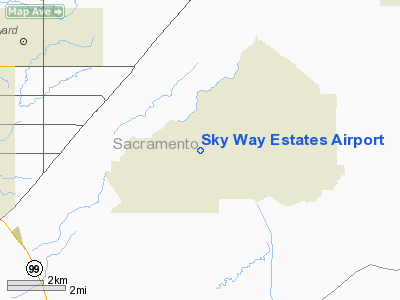
Sky Way Estates Airport
Address:
Sacramento County, CA
Tel:
916-687-6784,
916-687-6785
Images
and information placed above are from
http://www.airport-data.com/airport/CL04/
We
thank them for the data!
| General
Info |
| Country |
United
States |
| State |
CALIFORNIA
|
| FAA ID |
CL04
|
| Latitude |
38-24-38.678N
|
| Longitude |
121-14-05.812W
|
| Elevation |
92 feet
|
| Near City |
ELK GROVE
|
We don't guarantee the information is fresh and accurate. The data may
be wrong or outdated.
For more up-to-date information please refer to other sources.
|
|


