 |
|
|
|
Location
& QuickFacts
|
FAA
Information Effective: |
2006-09-28 |
|
Airport
Identifier: |
97CL |
|
Longitude/Latitude: |
121-34-49.8910W/39-27-36.5930N
-121.580525/39.460165 (Estimated) |
|
Elevation: |
235 ft / 71.63 m (Estimated) |
|
Land: |
0 acres |
|
From
nearest city: |
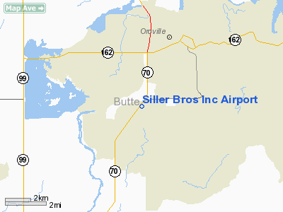
3 nautical miles S of Oroville, CA |
|
Location: |
Butte County, CA |
|
Magnetic Variation: |
16E (1985) |
Owner
& Manager
|
Ownership: |
Privately owned |
|
Owner: |
Sliver Bros., Inc. |
|
Address: |
P.o. Box 1585
Yuba City, CA 95991 |
|
Phone number: |
916-673-0734 |
|
Manager: |
Andre W M. Pekema |
|
Address: |
1255 Smith Road
Yuba, CA 95991 |
|
Phone number: |
916-673-0734 |
Airport
Operations and Facilities
|
Airport Use: |
Private |
|
Wind indicator: |
Yes |
|
Segmented Circle: |
Yes |
|
Control Tower: |
No |
|
Attendance Schedule: |
UNATNDD |
|
Landing fee charge: |
No |
|
Sectional chart: |
San Francisco |
|
Region: |
AWP - Western-Pacific |
|
Boundary ARTCC: |
ZOA - Oakland |
|
Tie-in FSS: |
RIU - Rancho Murieta |
|
FSS on Airport: |
No |
|
FSS Phone: |
916-354-0161 |
|
FSS Toll Free: |
1-800-WX-BRIEF |
Airport
Services
|
Airframe
Repair: |
NONE |
|
Power
Plant Repair: |
NONE |
|
Runway Information
Runway 02/20
|
Dimension: |
1900 x 180 ft / 579.1 x 54.9 m |
|
Surface: |
GRAVEL, |
|
|
Runway 02 |
Runway 20 |
|
Traffic
Pattern: |
Left |
Left |
|
Radio Navigation
Aids
|
ID |
Type |
Name |
Ch |
Freq |
Var |
Dist |
|
OVE |
NDB |
Oroville |
|
212.00 |
16E |
2.8 nm |
|
MY |
NDB |
Halow |
|
222.00 |
16E |
17.5 nm |
|
PBT |
NDB |
Proberta |
|
338.00 |
16E |
49.7 nm |
|
BAB |
TACAN |
Beale |
023X |
|
16E |
20.6 nm |
|
MYV |
VOR/DME |
Marysville |
045X |
110.80 |
16E |
21.7 nm |
|
CIC |
VOR/DME |
Chico |
035X |
109.80 |
16E |
23.3 nm |
|
MCC |
VOR/DME |
Mc Clellan |
029X |
109.20 |
17E |
48.4 nm |
|
MXW |
VORTAC |
Maxwell |
037X |
110.00 |
18E |
31.0 nm |
|
ILA |
VORTAC |
Williams |
091X |
114.40 |
18E |
31.3 nm |
|
RBL |
VORTAC |
Red Bluff |
104X |
115.70 |
18E |
48.9 nm |
|
SMF |
VOT |
Sacramento Metropolitan |
|
111.40 |
|
46.3 nm |
Remarks
- PLINE
SE OF RWY.
- RESTRICTED
PVT USE.
Siller Bros Inc Airport
Address:
Butte County, CA
Tel:
916-673-0734
Images
and information placed above are from
http://www.airport-data.com/airport/97CL/
We
thank them for the data!
| General
Info |
| Country |
United
States |
| State |
CALIFORNIA
|
| FAA ID |
97CL
|
| Latitude |
39-27-36.593N
|
| Longitude |
121-34-49.891W
|
| Elevation |
235 feet
|
| Near City |
OROVILLE
|
We don't guarantee the information is fresh and accurate. The data may
be wrong or outdated.
For more up-to-date information please refer to other sources.
|
|


