 |
|
Coordinates: 36°50′25″N 119°52′10″W / 36.84028°N 119.86944°W / 36.84028; -119.86944
| Sierra Sky Park Airport |
| IATA: none – ICAO: none – FAA LID: E79 |
| Summary |
| Airport type |
Public |
| Owner |
Herndon-Doolittle Assc, Inc. |
| Serves |
Fresno, California |
| Elevation AMSL |
321 ft / 98 m |
| Runways |
| Direction |
Length |
Surface |
| ft |
m |
| 12/30 |
2,920 |
890 |
Asphalt |
| Statistics (2007) |
| Aircraft operations |
12,500 |
| Based aircraft |
40 |
| Source: Federal Aviation Administration |
Sierra Sky Park Airport (FAA LID: E79, formerly Q60) is a privately-owned, public-use airport located seven miles (11 km) northwest of the central business district of Fresno, a city in Fresno County, California, United States.
Other area airports are Fresno Chandler Executive Airport and Fresno Yosemite International Airport. History
Sierra Sky Park was created in 1946 on 130 acres (52 ha) nestled against the San Joaquin River, and is the first residential aviation community in the world. William and Doris Smilie are credited for creating this airport/neighborhood hybrid and in 1953 built the first of the 110 homes in the project. Residents can land, taxi down extra-wide avenues, and pull up and park in the driveway at home.
Facilities and aircraft
Sierra Sky Park Airport covers an area of 34 acres (14 ha) which contains one runway designated 12/30 with a 2,920 x 50 ft (890 x 15 m) asphalt pavement. For the 12-month period ending March 29, 2007, the airport had 12,500 general aviation aircraft operations, an average of 34 per day. At that time there were 40 aircraft based at this airport: 98 percent single-engine and 2 percent multi-engine.
The above content comes from Wikipedia and is published under free licenses – click here to read more.
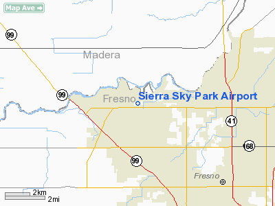
Location
& QuickFacts
|
FAA
Information Effective: |
2006-09-28 |
|
Airport
Identifier: |
E79 |
|
Longitude/Latitude: |
119-52-13.5400W/36-50-24.8110N
-119.870428/36.840225 (Estimated) |
|
Elevation: |
321 ft / 97.84 m (Estimated) |
|
Land: |
34 acres |
|
From
nearest city: |
7 nautical miles NW of Fresno, CA |
|
Location: |
Fresno County, CA |
|
Magnetic Variation: |
15E (1985) |
Owner
& Manager
|
Ownership: |
Privately owned |
|
Owner: |
Herndon-doolittle Assc, Inc.
ALSO THOMAS A SHEKOYAN - JOHN O JAMISSON - MICHAEL SHEEHAN
& ROBT K AUAKIAN. |
|
Address: |
5260 North Palm No. 421
Fresno, CA 93704 |
|
Phone
number: |
209-432-5400 |
|
Manager: |
Mike Sheehan |
|
Address: |
5260 North Palm No. 421
Fresno, CA 93704 |
|
Phone number: |
209-432-5400 |
Airport
Operations and Facilities
|
Airport
Use: |
Open to public |
|
Wind
indicator: |
Yes |
|
Segmented
Circle: |
Yes |
|
Control
Tower: |
No |
|
Attendance
Schedule: |
UNATNDD |
|
Lighting
Schedule: |
DUSK-DAWN |
|
Landing
fee charge: |
No |
|
Sectional
chart: |
San Francisco |
|
Region: |
AWP - Western-Pacific |
|
Traffic
Pattern Alt: |
979 ft |
|
Boundary
ARTCC: |
ZOA - Oakland |
|
Tie-in
FSS: |
RIU - Rancho Murieta |
|
FSS
on Airport: |
No |
|
FSS
Phone: |
916-354-0161 |
|
FSS
Toll Free: |
1-800-WX-BRIEF |
|
NOTAMs
Facility: |
RIU (NOTAM-d service avaliable) |
Airport
Communications
Airport
Services
|
Bottled
Oxygen: |
NONE |
|
Bulk
Oxygen: |
NONE |
|
Runway Information
Runway 12/30
|
Dimension: |
2920 x 50 ft / 890.0 x 15.2 m |
|
Surface: |
ASPH, Fair Condition |
|
Edge
Lights: |
Low |
|
|
Runway 12 |
Runway 30 |
|
Traffic
Pattern: |
Right |
Left |
|
Markings: |
Basic, Good Condition |
Basic, Good Condition |
|
Displaced
threshold: |
330.00 ft |
292.00 ft |
|
Runway
End Identifier: |
No |
No |
|
Centerline
Lights: |
No |
No |
|
Touchdown
Lights: |
No |
No |
|
Obstruction: |
10 ft road, 400.0 ft from runway, 125 ft right
of centerline, 20:1 slope to clear
APCH RATIO BETTER THAN 50:1 FM DSPLCD THLD.
+6 FT WALL 115 FT TO 130 FT FM RY END, 105 FT TO 125 FT L. |
15 ft road, 200.0 ft from runway, 20 ft left
of centerline
APCH RATIO FM DSPLCD THR 32:1.
+3-6 FT FENCE 40 FT & +8 FT PUMP HOUSE 50 FT FM RY END. |
|
Radio Navigation
Aids
|
ID |
Type |
Name |
Ch |
Freq |
Var |
Dist |
|
FCH |
NDB |
Chandler |
|
344.00 |
15E |
7.2 nm |
|
CUK |
NDB |
Academy |
|
266.00 |
14E |
13.1 nm |
|
COR |
NDB |
Salyer Farms |
|
205.00 |
16E |
49.2 nm |
|
NLC |
TACAN |
Lemoore |
080X |
|
16E |
30.2 nm |
|
VIS |
VOR/DME |
Visalia |
031X |
109.40 |
16E |
34.0 nm |
|
HYP |
VOR/DME |
El Nido |
089X |
114.20 |
15E |
34.1 nm |
|
CZQ |
VORTAC |
Clovis |
076X |
112.90 |
15E |
3.8 nm |
|
FRA |
VORTAC |
Friant |
103X |
115.60 |
17E |
20.7 nm |
|
PXN |
VORTAC |
Panoche |
073X |
112.60 |
16E |
44.4 nm |
Remarks
- CALM
WIND RY 30.
- E111
PROVIDED VFR; CONDITIONS ONLY.
Based Aircraft
|
Aircraft
based on field: |
40 |
|
Single
Engine Airplanes: |
39 |
|
Multi
Engine Airplanes: |
1 |
Operational Statistics
|
Aircraft
Operations: |
241/Week |
|
General
Aviation Local: |
80.0% |
|
General
Aviation Itinerant: |
20.0% |
Sierra Sky Park Airport
Address:
Fresno County, CA
Tel:
209-432-5400
Images
and information placed above are from
http://www.airport-data.com/airport/E79/
We
thank them for the data!
We don't guarantee the information is fresh and accurate. The data may
be wrong or outdated.
For more up-to-date information please refer to other sources.
|
|


