 |
|
Shafter-minter Field Airport |
Shafter Airport
Minter Field |
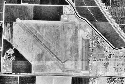 |
| 4 September 1994 |
| IATA: MIT – ICAO: KMIT – FAA LID: MIT |
| Summary |
| Owner |
Minter Field Airport District |
| Serves |
Shafter, California |
| Elevation AMSL |
421 ft / 128 m |
| Coordinates |
35°30′27″N 119°11′32″W / 35.5075°N 119.19222°W / 35.5075; -119.19222 |
| Runways |
| Direction |
Length |
Surface |
| ft |
m |
| 12/30 |
4,501 |
1,372 |
Asphalt |
| 17/35 |
2,972 |
906 |
Concrete |
| Statistics (2007) |
| Aircraft operations |
45,000 |
| Based aircraft |
89 |
| Source: Federal Aviation Administration |
Shafter Airport (IATA: MIT, ICAO: KMIT, FAA LID: MIT), also known as Minter Field, is a public use airport located four nautical miles (7 km) east of the central business district of Shafter, in Kern County, California, United States. It is owned by the Minter Field Airport District. Facilities and aircraft
The airport covers an area of 1,206 acres (488 ha) at an elevation of 421 feet (128 m) above mean sea level. It has two runways: 12/30 with 4,501 x 100 ft (1,372 x 30 m) asphalt surface and 17/35 with a 2,972 x 100 ft (906 x 30 m) concrete surface.
For the 12-month period ending January 18, 2007, the airport had 45,000 general aviation aircraft operations, an average of 123 per day. At that time there were 89 aircraft based at this airport: 81% single-engine, 3% multi-engine, 1% jet, 6% helicopter and 9% ultralight.
History
Lerdo Field, as the airport was initially known during World War II was first opened in June 1941 when the United States Army Air Corps (USAAC) dispatched a small garrison of airmen to open an airfield at Shafter.
The name was derived from close proximity to the highway of the same name. The airfield commander utilized Bakersfield College as his headquarters, while airmen were quartered in temporary facilities from Bakersfield to Wasco while barracks and other structures were being built. As construction proceeded though the rest of the year, the Minter Sub-Depot was established as a branch of the Sacramento Air Depot.
In August, the first operational training units (OTU)s began arriving at Minter, the airfields mission being advanced pilot training of USAAC bomber, attack, transport and pursuit pilots. In April 1942, contracts for the construction of more than 65 on-base buildings were let while the constantly increasing numbers of cadets were housed in a large tent city erected as temporary shelter.
With the relative completion of construction in July 1942, the airfield was renamed Minter Field a member of the locally prominent Minter family. The Lieutenant, a World War I veteran, was killed in a mid-air collision over March Field in July, 1932. The airfield was placed under the overall command of the United States Army Air Forces West Coast Training Center.
The primary aircraft flown at Minter Field was the Vultee BT-13 Valiant, which was used for basic flight training. Other training aircraft included the Cessna UC-78 Bobcat, as well as the AT-6 Texan advanced trainer, North American B-25 Mitchell twin-engine medium bomber, and Lockheed P-38 Lightning, as well as other widely used fighter, bomber and observation craft.
With the end of the war in 1945, airfield was determined to be excess by the military and turned over to the local government for civil use in March 1948.
The Gossamer Condor piloted by Bryan Allen won the first Kremer prize on August 23, 1977 by completing a figure '8' course specified by the Royal Aeronautical Society at Minter Field. A California State Monument is located at the Field for this event.
The above content comes from Wikipedia and is published under free licenses – click here to read more.
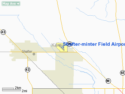
Location
& QuickFacts
|
FAA
Information Effective: |
2006-09-28 |
|
Airport
Identifier: |
MIT |
|
Longitude/Latitude: |
119-11-31.8200W/35-30-26.6100N
-119.192172/35.507392 (Estimated) |
|
Elevation: |
421 ft / 128.32 m (Surveyed) |
|
Land: |
1206 acres |
|
From
nearest city: |
4 nautical miles E of Shafter, CA |
|
Location: |
Kern County, CA |
|
Magnetic Variation: |
15E (1985) |
Owner
& Manager
|
Ownership: |
Publicly owned |
|
Owner: |
Minter Field Airport District |
|
Address: |
201 Aviation St
Shafter, CA 93263 |
|
Phone number: |
661-393-0402 |
|
Manager: |
Herman Ruddell |
|
Address: |
201 Aviation St
Shafter, CA 93263 |
|
Phone number: |
661-393-0402 |
Airport
Operations and Facilities
|
Airport
Use: |
Open to public |
|
Wind
indicator: |
Yes |
|
Segmented
Circle: |
Yes |
|
Control
Tower: |
No |
|
Attendance
Schedule: |
ALL/MON-FRI/0800-1700 |
|
Lighting
Schedule: |
DUSK-DAWN
HIRL RY 12/30 OPERS DUSK-0000; AFTER 0000 ACTVT - CTAF. |
|
Beacon
Color: |
Clear-Green (lighted land airport) |
|
Landing
fee charge: |
No |
|
Sectional
chart: |
Los Angeles |
|
Region: |
AWP - Western-Pacific |
|
Traffic
Pattern Alt: |
1000 ft |
|
Boundary
ARTCC: |
ZLA - Los Angeles |
|
Tie-in
FSS: |
RIU - Rancho Murieta |
|
FSS
on Airport: |
No |
|
FSS
Phone: |
916-354-0161 |
|
FSS
Toll Free: |
1-800-WX-BRIEF |
|
NOTAMs
Facility: |
RIU (NOTAM-d service avaliable) |
|
Federal Agreements: |
NGPY |
Airport
Communications
Airport
Services
|
Fuel
available: |
100LLA |
|
Airframe
Repair: |
MAJOR |
|
Power
Plant Repair: |
MAJOR |
|
Bottled
Oxygen: |
NONE |
|
Bulk
Oxygen: |
NONE |
|
Runway Information
Runway 12/30
|
Dimension: |
4501 x 100 ft / 1371.9 x 30.5 m |
|
Surface: |
ASPH, Good Condition |
|
Weight
Limit: |
Single wheel: 22000 lbs. |
|
Edge
Lights: |
High |
|
|
Runway 12 |
Runway 30 |
|
Longitude: |
119-12-03.6800W |
119-11-24.1000W |
|
Latitude: |
35-30-38.4300N |
35-30-07.8700N |
|
Elevation: |
410.00 ft |
410.00 ft |
|
Alignment: |
127 |
127 |
|
Traffic
Pattern: |
Left |
Left |
|
Markings: |
Basic, Good Condition |
Basic, Good Condition |
|
VASI: |
|
2-light PAPI on left side |
|
Runway
End Identifier: |
No |
No |
|
Centerline
Lights: |
No |
No |
|
Touchdown
Lights: |
No |
No |
|
Runway 17/35
|
Dimension: |
2972 x 100 ft / 905.9 x 30.5 m |
|
Surface: |
CONC, Good Condition |
|
Weight
Limit: |
Single wheel: 25000 lbs.
Dual wheel: 30000 lbs. |
|
|
Runway 17 |
Runway 35 |
|
Longitude: |
119-11-09.4800W |
119-11-09.5000W |
|
Latitude: |
35-30-33.5200N |
35-30-04.1300N |
|
Elevation: |
421.00 ft |
412.00 ft |
|
Alignment: |
127 |
0 |
|
Traffic
Pattern: |
Left |
Left |
|
Markings: |
Basic, Good Condition |
Basic, Good Condition |
|
Runway
End Identifier: |
No |
No |
|
Centerline
Lights: |
No |
No |
|
Touchdown
Lights: |
No |
No |
|
Obstruction: |
15 ft road, 850.0 ft from runway, 190 ft left
of centerline, 43:1 slope to clear |
15 ft road, 470.0 ft from runway, 18:1 slope
to clear |
|
Radio Navigation
Aids
|
ID |
Type |
Name |
Ch |
Freq |
Var |
Dist |
|
COR |
NDB |
Salyer Farms |
|
205.00 |
16E |
37.6 nm |
|
TTE |
VOR/DME |
Tule |
029X |
109.20 |
16E |
25.8 nm |
|
EHF |
VORTAC |
Shafter |
101X |
115.40 |
14E |
4.8 nm |
|
AVE |
VORTAC |
Avenal |
118X |
117.10 |
16E |
39.4 nm |
|
FLW |
VORTAC |
Fellows |
122X |
117.50 |
16E |
41.4 nm |
|
GMN |
VORTAC |
Gorman |
108X |
116.10 |
16E |
45.3 nm |
|
BFL |
VOT |
Bakersfield |
|
111.20 |
|
8.7 nm |
Remarks
- HEAVY
CROP DUSTER ACTIVITY INVOF ARPT.
- SELF-SERVICE
FUEL AVBL 24 HRS WITH MAJOR CREDIT CARD.
- ULTRALIGHT
ACTIVITY ON & INVOF ARPT.
Based Aircraft
|
Aircraft
based on field: |
89 |
|
Single
Engine Airplanes: |
72 |
|
Multi
Engine Airplanes: |
3 |
|
Jet Engine
Airplanes: |
1 |
|
Helicopters: |
5 |
|
Ultralights: |
8 |
Operational Statistics
|
Aircraft
Operations: |
124/Day |
|
General
Aviation Local: |
44.4% |
|
General
Aviation Itinerant: |
55.6% |
Shafter-minter Field Airport
Address:
Kern County, CA
Tel:
661-393-0402
Images
and information placed above are from
http://www.airport-data.com/airport/MIT/
We
thank them for the data!
| General
Info |
| Country |
United
States |
| State |
CALIFORNIA
|
| FAA ID |
MIT
|
| Latitude |
35-30-21.346N
|
| Longitude |
119-11-29.485W
|
| Elevation |
422 feet
|
| Near City |
SHAFTER
|
We don't guarantee the information is fresh and accurate. The data may
be wrong or outdated.
For more up-to-date information please refer to other sources.
|
|


