 |
|
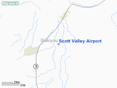
| Scott Valley Airport |
 |
| IATA: none – ICAO: none – FAA LID: A30 |
| Summary |
| Airport type |
Public |
| Operator |
County of Siskiyou |
| Location |
Fort Jones, California |
| Elevation AMSL |
2,728 ft / 831.5 m |
| Coordinates |
41°33′30″N 122°51′19″W / 41.55833°N 122.85528°W / 41.55833; -122.85528Coordinates: 41°33′30″N 122°51′19″W / 41.55833°N 122.85528°W / 41.55833; -122.85528 |
| Runways |
| Direction |
Length |
Surface |
| ft |
m |
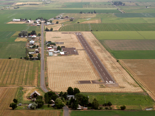
| 16/34 |
3,700 |
1,128 |
Asphalt |
Scott Valley Airport (FAA LID: A30), formerly CA06, is a public airport located three miles (4.8 km) south of the central business district (CBD) of Fort Jones, a city in Siskiyou County, California, USA. The airport covers 53 acres and has one runway.
The above content comes from Wikipedia and is published under free licenses – click here to read more.
Location
& QuickFacts
|
FAA
Information Effective: |
2006-09-28 |
|
Airport
Identifier: |
A30 |
|
Longitude/Latitude: |
122-51-19.1170W/41-33-29.5000N
-122.855310/41.558194 (Estimated) |
|
Elevation: |
2728 ft / 831.49 m (Surveyed) |
|
Land: |
53 acres |
|
From
nearest city: |
3 nautical miles S of Fort Jones, CA |
|
Location: |
Siskiyou County, CA |
|
Magnetic Variation: |
18E (1985) |
Owner
& Manager
|
Ownership: |
Publicly owned |
|
Owner: |
County Of Siskiyou |
|
Address: |
305 Butte St
Yreka, CA 96097 |
|
Phone
number: |
530-842-8295 |
|
Manager: |
Thomas L. Anderson
COUNTY AIRPORT OFFICE - YREKA |
|
Address: |
305 Butte Street.
Yreka, CA 96097 |
|
Phone
number: |
530-842-8295
COUNTY DIR OF ARPTS OFFICE IN YREKA. |
Airport
Operations and Facilities
|
Airport
Use: |
Open to public |
|
Wind
indicator: |
Yes |
|
Segmented
Circle: |
Yes |
|
Control
Tower: |
No |
|
Attendance
Schedule: |
UNATNDD |
|
Lighting
Schedule: |
DUSK-DAWN
ACTVT MIRL RWY 16/34 - CTAF. |
|
Beacon
Color: |
Clear-Green (lighted land airport) |
|
Landing
fee charge: |
No |
|
Sectional
chart: |
Klamath Falls |
|
Region: |
AWP - Western-Pacific |
|
Traffic
Pattern Alt: |
800 ft |
|
Boundary
ARTCC: |
ZSE - Seattle |
|
Tie-in
FSS: |
RIU - Rancho Murieta |
|
FSS
on Airport: |
No |
|
FSS
Phone: |
916-354-0161 |
|
FSS
Toll Free: |
1-800-WX-BRIEF |
|
NOTAMs
Facility: |
RIU (NOTAM-d service avaliable) |
|
Federal Agreements: |
NGY |
Airport
Communications
|
CTAF: |
122.800 |
|
Unicom: |
122.800
OPN NOT CONTINUOUS; LOCATED IN ADJACENT RESIDENCE. |
Airport
Services
|
Fuel
available: |
100LL |
|
Airframe
Repair: |
NONE |
|
Power
Plant Repair: |
NONE |
|
Bottled
Oxygen: |
NONE |
|
Bulk
Oxygen: |
NONE |
|
Runway Information
Runway 16/34
|
Dimension: |
3700 x 50 ft / 1127.8 x 15.2 m |
|
Surface: |
ASPH, Fair Condition |
|
Weight
Limit: |
Single wheel: 12000 lbs. |
|
Edge
Lights: |
Medium |
|
|
Runway 16 |
Runway 34 |
|
Traffic
Pattern: |
Right |
Left |
|
Markings: |
Basic, Fair Condition |
Basic, Good Condition |
|
Displaced
threshold: |
0.00
ft |
200.00 ft |
|
Runway
End Identifier: |
No |
No |
|
Centerline
Lights: |
No |
No |
|
Touchdown
Lights: |
No |
No |
|
Obstruction: |
25 ft tree, 710.0 ft from runway, 160 ft left
of centerline, 20:1 slope to clear |
40 ft tree, 1800.0 ft from runway, 40:1 slope
to clear
RWY 34 APCH SLOPE 50:1 TO DISPLACED THRESHOLD
+4 FT FENCE 360 FT FM DISP THLD 160 FT FM EOR. |
|
Radio Navigation
Aids
|
ID |
Type |
Name |
Ch |
Freq |
Var |
Dist |
|
MOG |
NDB |
Montague |
|
404.00 |
19E |
19.6 nm |
|
FJS |
VOR/DME |
Fort Jones |
033X |
109.60 |
19E |
6.9 nm |
|
MFR |
VOT |
Medford-jackson County |
|
117.20 |
|
48.1 nm |
Remarks
- RWY
34 LGTD THR RELOCATED 200' FOR NGT OPNS. 3500' OF RWY 16/34 USABLE AT
NGT.
Based Aircraft
|
Aircraft
based on field: |
20 |
|
Single
Engine Airplanes: |
18 |
|
Helicopters: |
1
U.S. FOREST SVC HELICOPTER MAY THRU SEP. |
|
Ultralights: |
1 |
Operational Statistics
|
Aircraft
Operations: |
156/Week |
|
Air Taxi: |
1.3% |
|
General
Aviation Local: |
37.0% |
|
General
Aviation Itinerant: |
61.7% |
Scott Valley Airport
Address:
Siskiyou County, CA
Tel:
530-842-8295
Images
and information placed above are from
http://www.airport-data.com/airport/A30/
We
thank them for the data!
| General
Info |
| Country |
United
States |
| State |
CALIFORNIA
|
| FAA ID |
A30
|
| Latitude |
41-33-29.500N
|
| Longitude |
122-51-19.117W
|
| Elevation |
2728 feet
|
| Near City |
FORT JONES
|
We don't guarantee the information is fresh and accurate. The data may
be wrong or outdated.
For more up-to-date information please refer to other sources.
|
|


