San Clemente Island Nalf Airport in California California airports - San Clemente Island Nalf Airport
San Clemente Island Nalf Airport in California - United States
California Airports
USA Airports
World Airports
Airport photos - free!
Aircraft photos - free!
Spacecraft pics - free!
Aviation Articles

San Clemente Island Nalf Airport


NALF San Clemente Island
Frederick Sherman Field
IATA: none – ICAO: KNUC – FAA LID: NUC
Summary
Airport type Military
Operator U.S. Navy
Location San Clemente Island
Elevation AMSL 184 ft / 56.1 m
Coordinates 33°01′22″N 118°35′19″W / 33.02278°N 118.58861°W / 33.02278; -118.58861Coordinates: 33°01′22″N 118°35′19″W / 33.02278°N 118.58861°W / 33.02278; -118.58861
Runways
Direction Length Surface
ft m
5/23 9,301 2,835 Concrete

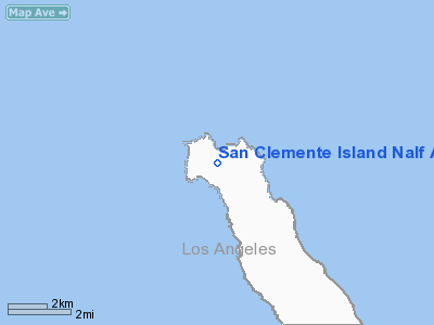
Naval Auxiliary Landing Field (NALF) San Clemente Island (ICAO: KNUC, FAA LID: NUC), also known as Frederick Sherman Field, is a military airport located on San Clemente Island, in Los Angeles County, California, USA. It has been owned by the United States Navy since 1937, but came into its current importance during the past decade. It is the Navy's only remaining live fire range. San Clemente is the southernmost Channel Island, covering 57 square miles (150 km²). The island is approximately 21 nmi (39 km) long and is 4.5 nmi (8 km) across at its widest point. It lies 55 nmi (102 km) south of Long Beach and 68 nmi (130 km) west of San Diego, California.

Operations

One of the primary military function of San Clemente has been to support research and development of many of the Navy's weapon systems. In 1939, the Navy developed the first Landing Craft, Vehicle and Personnel (LCVP) "Higgins Boat" at SCI. This was the beginning of the Naval Amphibious Force, which was one of the key factors in the outcome of World War II. Today SCI's primary function is twofold: (1) to support tactical training of the Pacific Fleet, and (2) to continue as a key research and development facility. SCI provides the Navy and Marine Corps a multi-threat warfare training range. A major part of Navy training takes place on the ranges right off the SCI shores. The primary range covers over 149,000 square miles (386,000 km²) and is the Navy's busiest Fleet airspace. Also included in this training area are two mine exercise areas, the Southern California Anti-Submarine Warfare Range, seven submarine areas, the shallow water Undersea Training Range, and two laser training ranges. In total, SCI is a unique combination of airfields, airspace and ranges unlike any other facility owned by the Navy. It is the only location in the Pacific where surface ships, submarines, aircraft and Navy expeditionary forces can train in all warfare areas simultaneously using shore gunnery, bombardment, air defense, anti sub and electronic warfare

Environment

To reduce the use of diesel fuel and prevent harmful emissions, the Naval facility on San Clemente Island installed three 225 kilowatt wind turbines. From February 1998 to April 2000, the turbines produced two GWh, approximately 13 percent of the island’s total electricity needs. In FY99, the turbines helped the installation decrease consumption of 141,757 US gallons (537 m³) of No. 2 diesel fuel, and avoided 18,450 pounds (8,369 kg) of carbon monoxide emissions. In the future, the turbines should provide 15 percent or more of the island’s electricity, further reducing diesel fuel use and emissions


The above content comes from Wikipedia and is published under free licenses – click here to read more.
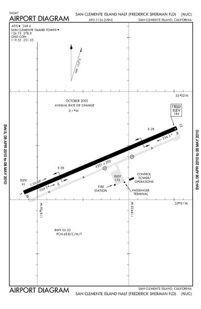
San Clemente Island Nalf Airport picture

Location & QuickFacts

FAA Information Effective:

2006-09-28

Airport Identifier:

NUC

Longitude/Latitude:

118-35-18.5590W/33-01-21.8820N
-118.588489/33.022745 (Estimated)

Elevation:

184 ft / 56.08 m (Estimated)

Land:

0 acres

From nearest city:

0 nautical miles NW of San Clemente Island, CA

Location:

Orange County, CA

Magnetic Variation:

14E (1985)


Owner & Manager

Ownership:

Navy owned

Owner:

Us Navy

Address:

Oceanographic Ofc - Code 3142
Washington, DC 20373

Address:


Airport Operations and Facilities

Airport Use:

Private

Segmented Circle:

No

Control Tower:

Yes

Attendance Schedule:

ALL/MON-THU/1600-0200Z+,ALL/FRI/1600-2400Z+,CLSD SAT, SUN AND HOL.

Lighting Schedule:

DUSK-DAWN
SERVICE - LGT: ACTIVATE 5 STEP HIRL RWY 5-23, 1 STEP REIL RWY 5-23 AFTER NORMAL WORKING HOURS FOR EMERGENCIES 119.55.

Beacon Color:

Split-Clear-Green (lighted military airport)

Sectional chart:

Los Angeles

Region:

AWP - Western-Pacific

Boundary ARTCC:

ZLA - Los Angeles

Tie-in FSS:

NZY - San Diego
FSS-SAN DIEGO SAN-NOTAM KNUC

FSS on Airport:

No

FSS Phone:

714-437-6845

FSS Toll Free:

LD545-8234

NOTAMs Facility:

NUC (NOTAM-d service avaliable)


Airport Services

Bottled Oxygen:

NONE

Bulk Oxygen:

NONE


Runway Information

Runway 05/23

Dimension:

9301 x 200 ft / 2834.9 x 61.0 m

Surface:

CONC,

Weight Limit:

Single wheel: 156000 lbs.
Dual wheel: 225000 lbs.
Dual tandem wheel: 385000 lbs.

Edge Lights:

High


Runway 05

Runway 23

Longitude:

118-36-08.9430W

118-34-28.1740W

Latitude:

33-01-04.1240N

33-01-39.6400N

Elevation:

91.00 ft

184.00 ft

Traffic Pattern:

Left

Left

Arresting:

E28

E28

Runway End Identifier:

Yes

Yes

Centerline Lights:

No

No


Radio Navigation Aids

ID

Type

Name

Ch

Freq

Var

Dist

NUC

NDB

San Clemente


350.00

15E

0.9 nm

NSI

NDB

San Nicolas Island


203.00

14E

45.2 nm

NUC

TACAN

San Clemente

123X


15E

0.5 nm

NSI

TACAN

San Nicolas

039X


15E

45.6 nm

SXC

VORTAC

Santa Catalina

051X

111.40

15E

22.8 nm

LAX

VOT

San Pedro Hill


113.90


45.3 nm


Remarks

  • RWY-LGTS: RWY 23, OLS.
  • JASU - 1(GTC-85) 1(A-4).
  • FUEL - J5.
  • FLUID - SP.
  • CAUTION - EXTV MISL AND OFF-SHORE BOMBARDMENT IN VCNTY SAN CLEMENTE ISLAND. BEAVER TACAN NSD CH 86 LCTD 11 NM S OF NUC TACAN CH 123. PERIMETER RD IN CLOSE PROXIMITY TO AIRFIELD, USE EXTREME CAUTION. HOLD SHORT MARKINGS LESS THAN 175 FT. EXPECT HOLD SHORT INSTRUCTIONS FROM TOWER.
  • TFC PAT - REDUCED RWY SEPARATION STD IN EFF USN/USMC ACFT.
  • RSTD - PPR FOR CIV ACFT AT ALL TIMES AND MIL OT, DSN 524-9240. REQ TO USE NUC AS BINGO FLD FOR CARRIER OPR RQR 7 DAYS PN AND SPECIAL AIR OPR AFTER NML OPR HR RQR 72 HR PN THRU SAN CLEMENTE ISLAND AIR OPS DSN 524-9240.


San Clemente Island Nalf Airport  

Address: Orange County, CA

Tel:


Images and information placed above are from
http://www.airport-data.com/airport/NUC/

We thank them for the data!


General Info
Country United States
State CALIFORNIA
FAA ID NUC
Latitude 33-01-24.120N
Longitude 118-35-17.291W
Elevation 182 feet
Near City SAN CLEMENTE ISLAND


We don't guarantee the information is fresh and accurate. The data may be wrong or outdated.
For more up-to-date information please refer to other sources.


christianity portal
directory of hotels worldwide


Copyright 2004-2024 © by Airports-Worldwide.com, Vyshenskoho st. 36, Lviv 79010, Ukraine
Legal Disclaimer