|
 |
|
||||
|
Runway layout at SBD
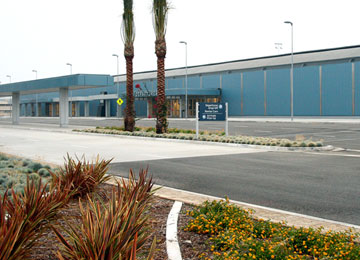
San Bernardino International Airport (IATA: SBD, ICAO: KSBD, FAA LID: SBD) is a public airport located two miles (3 km) southeast of the central business district of San Bernardino, California, in San Bernardino County, California, USA. The airport covers 1,329 acres (538 ha) and has one runway. It is currently a general aviation and cargo airport located on the former site of Norton Air Force Base. A non-federal control tower (NFCT) began operation on November 9, 2008, operated under contract by SERCO company personnel. The new tower frequency is 119.45. HistoryNorton Air Force BaseThe airbase opened shortly after the attacks on Pearl Harbor to protect the Southern California area. Norton was placed on the Department of Defense's base closure list in 1989 (the same year that the DoD signed the Federal Facilities Agreement with the EPA). The closure was cited as due to environmental wastes, inadequate facilities, and air traffic congestion (due to air traffic from Ontario International Airport, 20 miles (32 km) west, and Los Angeles International Airport, 100 miles (160 km) west). The last of the facilities on the base were closed in 1995. StatusU.S. Customs Service agents are available on call to clear imported goods. The airport is used as a base for United States Forest Service planes fighting forest fires. Several hangars that were formerly empty have recently been occupied by civilian-owned aircraft maintenance companies. The runway is 10,000 feet (3,000 m) long, easily accommodating air cargo aircraft. However, UPS Airlines and FedEx Express choose to use LA/Ontario International Airport to the west, while DHL uses the March Air Reserve Base to the south. The airport and surrounding areas are within the City of San Bernardino, and the Inland Valley Development Agency. The airport and surrounding areas are being redeveloped by Hillwood. The airport temporarily housed SAM 27000 while the Air Force One Pavilion at the Ronald Reagan Presidential Library was under construction. Several major projects for the former air base and surrounding area are imminent or already under way, including Stater Bros. Markets which moved its corporate headquarters from Colton to the former air base site in September 2007. The 170,000-square-foot (16,000 m) offices are completed. Stater Bros. began moving warehousing and distribution operations into a 2,100,000-square-foot (195,000 m) facility in February 2007. Part of a $300 million-plus total investment in the city, the warehouse is the largest supermarket distribution facility in the nation, Brown said. The airport has served as the filming location for both the 2001 movie The Fast and the Furious and the 2004 Martin Scorsese film The Aviator using a Lockheed Constellation preserved by the Airline History Museum, and flown in for the shoot, were done at San Bernardino International, with one hanger "dressed" as a Trans World Airlines facility. Passenger service, renovations and location
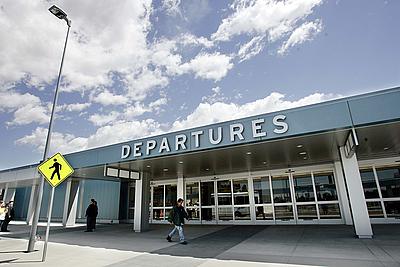
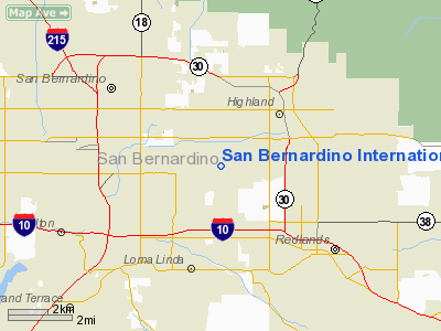
San Bernardino International Airport is currently undergoing a major renovation to prepare the airport for upcoming passenger service. The main terminal building was recently redone. An extra story was added and also a new baggage claim concourse as well. An all new international terminal is also under construction. New signs were added to guide people to the main terminal building and parking from as far away as the I-10/Tippecanoe interchange. The roads in the surrounding area have also been widened, repaved, or otherwise improved to handle an increase in traffic. San Bernardino has a long runway which will make it an alternate landing site for large aircraft. It is expected to be a particularly important alternate airport since there are many trans-Pacific flights headed to LAX and other nearby airports including Ontario and Palm Springs. LocationThe airport is located approximately 2 miles (3 km) east of downtown San Bernardino, 22 miles (29 km) east of Ontario and 14 miles (23 km) northeast of downtown Riverside. Motorists can either use the San Bernardino Freeway (Interstate 10), Barstow-Downtown San Bernardino-Riverside Freeway (Interstate 215), or the Foothill Freeway (State Route 210) to access the airport. It is also served by Omnitrans route 8. In combination with the Metrolink and Amtrak station in western San Bernardino, passengers will be able to access the airport via train and bus from all over SoCal. Airlines and destinationsCurrently, no airlines operate any regularly scheduled service out of KSBD, although Southeastern Jet Corporation plans to begin a private charter service at the airport in the fall of 2009. Million Air, a fixed base operation company formally opened its doors at the new MillionAir terminal in May 2010.
The above content comes from Wikipedia and is published under free licenses – click here to read more.
Runway InformationRunway 06/24
Radio Navigation Aids
Remarks
Based Aircraft
Operational Statistics
San Bernardino International Airport Address: San Bernardino County, CA Tel: 909-382-4100 Images
and information placed above are from We thank them for the data!
We don't guarantee the information is fresh and accurate. The data may
be wrong or outdated. |
||||||||||||||||||||||||||||||||||||||||||||||||||||||||||||||||||||||||||||||||||||||||||||||||||||||||||||||||||||||||||||||||||||||||||||||||||||||||||||||||||||||||||||||||||||||||||||||||||||||||||||||||||||||||||||||||||||||||||||||||||||||||||||||||||||||||||||||||||||||||||||||||||||||||||||||||||||||||||||||||||||||||||||||||||||||||||||||||||||||||||||||||||

 |
|
Copyright 2004-2026 © by Airports-Worldwide.com, Vyshenskoho st. 36, Lviv 79010, Ukraine Legal Disclaimer |