 |
|
San Bernardino County Medical Center Heliport |
|
|
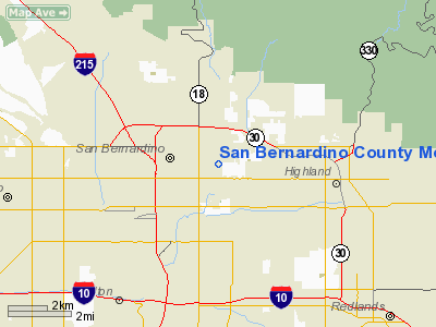
Location
& QuickFacts
|
FAA
Information Effective: |
2006-09-28 |
|
Airport
Identifier: |
CA80 |
|
Longitude/Latitude: |
117-16-03.1520W/34-07-40.0390N
-117.267542/34.127789 (Estimated) |
|
Elevation: |
1124 ft / 342.60 m (Estimated) |
|
Land: |
0 acres |
|
From
nearest city: |
2 nautical miles W of San Bernardino, CA |
|
Location: |
San Bernardino County, CA |
|
Magnetic Variation: |
14E (1985) |
Owner
& Manager
|
Ownership: |
Privately owned |
|
Owner: |
County Medical Center |
|
Address: |
780 E Gilbert St
San Bernardino, CA 92415-0935 |
|
Phone
number: |
909-387-7733 |
|
Manager: |
Mario Labani |
|
Address: |
780 E Gilbert St
San Bernardino, CA 92415-0935 |
|
Phone number: |
909-387-7736 |
Airport
Operations and Facilities
|
Airport Use: |
Private
MEDICAL. |
|
Wind indicator: |
Yes |
|
Segmented Circle: |
No |
|
Control Tower: |
No |
|
Attendance Schedule: |
ALL/ALL/ALL |
|
Lighting Schedule: |
DUSK-DAWN |
|
Beacon Color: |
Clear (unlighted land airport) |
|
Landing fee charge: |
No |
|
Sectional chart: |
Los Angeles |
|
Region: |
AWP - Western-Pacific |
|
Boundary ARTCC: |
ZLA - Los Angeles |
|
Tie-in FSS: |
RAL - Riverside |
|
FSS on Airport: |
No |
|
FSS Phone: |
951-351-3020 |
|
FSS Toll Free: |
1-800-WX-BRIEF |
Airport
Services
|
Airframe
Repair: |
NONE |
|
Power
Plant Repair: |
NONE |
|
Runway Information
Helipad H1
|
Dimension: |
60 x 60 ft / 18.3 x 18.3 m |
|
Surface: |
CONC, |
|
|
Runway H1 |
Runway |
|
Elevation: |
1200.00 ft |
0.00
ft |
|
Traffic
Pattern: |
Left |
Left |
|
Radio Navigation
Aids
|
ID |
Type |
Name |
Ch |
Freq |
Var |
Dist |
|
SB |
NDB |
Petis |
|
397.00 |
14E |
6.5 nm |
|
SJY |
NDB |
San Jacinto |
|
227.00 |
14E |
24.1 nm |
|
EMT |
NDB |
El Monte |
|
359.00 |
15E |
38.1 nm |
|
RIV |
TACAN |
March |
077X |
|
14E |
13.3 nm |
|
RAL |
VOR |
Riverside |
|
112.40 |
15E |
13.9 nm |
|
HDF |
VOR |
Homeland |
|
113.40 |
14E |
21.5 nm |
|
VCV |
VOR/DME |
Victorville |
031X |
109.40 |
14E |
28.7 nm |
|
ELB |
VOR/DME |
El Toro |
119X |
117.20 |
14E |
35.7 nm |
|
PDZ |
VORTAC |
Paradise |
059X |
112.20 |
15E |
18.2 nm |
|
POM |
VORTAC |
Pomona |
041X |
110.40 |
15E |
26.0 nm |
|
SLI |
VORTAC |
Seal Beach |
104X |
115.70 |
15E |
44.4 nm |
|
PSP |
VORTAC |
Palm Springs |
102X |
115.50 |
13E |
44.5 nm |
|
PMD |
VORTAC |
Palmdale |
092X |
114.50 |
15E |
49.8 nm |
|
SNA |
VOT |
Santa Ana |
|
110.00 |
|
40.5 nm |
Remarks
- PROVIDED
PVT USE VFR ONLY; FOR OPNS SS-SR HELIPORT LIGHTING BE INSTALLED IN ACCORDANCE
WITH FAA AC 150/5390-2 CHAPTER 2 OR 3; L OA WITH NORTON AFB TWR MGR;
REMOVE EXISTING TREES & LIGHT POLES SO AS N OT TO PENETRATE 8:1
SLOPE.
San Bernardino County Medical Center Heliport
Address:
San Bernardino County, CA
Tel:
909-387-7733,
909-387-7736
Images
and information placed above are from
http://www.airport-data.com/airport/CA80/
We
thank them for the data!
| General
Info |
| Country |
United
States |
| State |
CALIFORNIA
|
| FAA ID |
CA80
|
| Latitude |
34-07-40.039N
|
| Longitude |
117-16-03.152W
|
| Elevation |
1124 feet
|
| Near City |
SAN BERNARDINO
|
We don't guarantee the information is fresh and accurate. The data may
be wrong or outdated.
For more up-to-date information please refer to other sources.
|
|


