|
|
Salinas Municipal Airport |
| Salinas Municipal Airport |
 |
| IATA: SNS – ICAO: KSNS – FAA LID: SNS |
| Summary |
| Airport type |
Public |
| Owner |
City of Salinas |
| Serves |
Salinas, California |
| Elevation AMSL |
85 ft / 26 m |
| Coordinates |
36°39′46″N 121°36′23″W / 36.66278°N 121.60639°W / 36.66278; -121.60639 |
| Runways |
| Direction |
Length |
Surface |
| ft |
m |
| 8/26 |
6,004 |
1,830 |
Asphalt |
| 13/31 |
4,825 |
1,471 |
Asphalt |
| 14/32 |
1,900 |
579 |
Asphalt |
| Helipads |
| Number |
Length |
Surface |
| ft |
m |
| H1 |
90 |
27 |
Asphalt/Concrete |
| Statistics (2007) |
| Aircraft operations |
77,896 |
| Based aircraft |
229 |
| Source: Federal Aviation Administration |
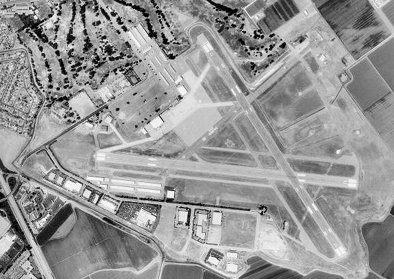
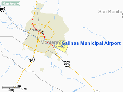
Salinas Municipal Airport (IATA: SNS, ICAO: KSNS, FAA LID: SNS) is a city-owned public-use airport located three nautical miles (6 km) southeast of the central business district of Salinas, a city in Monterey County, California, United States. Facilities and aircraft
Salinas Municipal Airport covers 605 acres (245 ha) which contain three asphalt paved runways: 8/26 measuring 6,004 x 150 ft. (1,830 x 46 m), 13/31 at 4,825 x 150 ft. (1,471 x 46 m), and 14/32 at 1,900 x 50 ft. (579 x 15 m). It also has one helipad with a 90 x 90 ft. (27 x 27 m) asphalt/concrete surface.
For the 12-month period ending June 30, 2007, the airport had 77,896 aircraft operations, an average of 213 per day: 97% general aviation, 2% air taxi and 1% military. At that time there were 229 aircraft based at this airport: 70% single-engine, 21% multi-engine, 3% jet and 6% helicopter.
History
The airfield was opened in June 1942 during World War II as Salinas Army Air Base (AAB). It was used by the United States Army Air Forces Fourth Air Force as a subpost to Fort Ord during the war. Its mission was that of an incoming personnel processing center and a training field for Army pilots in reconnaissance and observation duties in various aircraft from light observation planes to medium bombers. The Air Transport Command also used the field and had an air freight terminal here for transshipment of cargo.
In January 1944, the Air University Army Air Forces School of Applied Tactics (AAFSAT) moved its 481st Night Fighter Operational Training Group from Orlando Army Airbase, Florida to California and assigned its 348th Night Fighter Squadron to the airport. Flying P-70s and A-20 Havoc training fighters, the squadron trained training replacement pilots at the airport until the end of the war in September 1945.
With the end of the war, the base was declared excess to requirements and returned to civil control.
California International Airshow
Salinas Airport is the location of the annual California International Airshow, set at various times from early August to early October. The air show often features top-tier aerobatic teams such as the Canadian Forces Snowbirds, U.S. Air Force Thunderbirds and the U.S. Navy Blue Angels, with the proceeds going to local charities.
The above content comes from Wikipedia and is published under free licenses – click here to read more.
Location
& QuickFacts
|
FAA
Information Effective: |
2006-09-28 |
|
Airport
Identifier: |
SNS |
|
Longitude/Latitude: |
121-36-22.9000W/36-39-46.0000N
-121.606361/36.662778 (Estimated) |
|
Elevation: |
85 ft / 25.91 m (Surveyed) |
|
Land: |
605 acres |
|
From
nearest city: |
3 nautical miles SE of Salinas, CA |
|
Location: |
Monterey County, CA |
|
Magnetic Variation: |
16E (1980) |
Owner
& Manager
|
Ownership: |
Publicly owned |
|
Owner: |
City Of Salinas |
|
Address: |
200 Lincoln Ave
Salinas, CA 93901 |
|
Phone number: |
831-758-7214 |
|
Manager: |
Gary Petersen |
|
Address: |
30 Mortensen Ave
Salinas, CA 93905 |
|
Phone number: |
831-758-7214 |
Airport
Operations and Facilities
|
Airport
Use: |
Open to public |
|
Wind
indicator: |
Yes |
|
Segmented
Circle: |
No |
|
Control
Tower: |
Yes |
|
Attendance
Schedule: |
ALL/ALL/ALL |
|
Lighting
Schedule: |
DUSK-DAWN
WHEN ATCT CLSD ACTVT MIRL RY 08/26, HIRL RY 13/31 AND MALSR
RY 31 - CTAF. REIL RY 13, VASI RYS 08 AND 26, VASI RY 13
AND PAPI RY 31 OPER CONTINUOUSLY. |
|
Beacon
Color: |
Clear-Green (lighted land airport) |
|
Landing
fee charge: |
No |
|
Sectional
chart: |
San Francisco |
|
Region: |
AWP - Western-Pacific |
|
Traffic
Pattern Alt: |
800 ft |
|
Boundary
ARTCC: |
ZOA - Oakland |
|
Tie-in
FSS: |
OAK - Oakland |
|
FSS
on Airport: |
No |
|
FSS
Phone: |
510-273-6111 |
|
FSS
Toll Free: |
1-800-WX-BRIEF |
|
NOTAMs
Facility: |
SNS (NOTAM-d service avaliable) |
|
Federal Agreements: |
NGPY |
Airport
Communications
|
CTAF: |
119.400 |
|
Unicom: |
122.950 |
Airport
Services
|
Fuel
available: |
100LLA |
|
Airframe
Repair: |
MAJOR |
|
Power
Plant Repair: |
MAJOR |
|
Bottled
Oxygen: |
HIGH |
|
Bulk
Oxygen: |
NONE |
|
Runway Information
Runway 08/26
|
Dimension: |
6004
x 150 ft / 1830.0 x 45.7 m
200 FT ASPH STWY RY 31. |
|
Surface: |
ASPH, Good Condition |
|
Weight
Limit: |
Single wheel: 25000 lbs.
Dual wheel: 32000 lbs.
Dual
tandem wheel: 62000 lbs. |
|
Edge
Lights: |
Medium |
|
|
Runway 08 |
Runway 26 |
|
Longitude: |
121-37-06.7401W |
121-35-53.5742W |
|
Latitude: |
36-39-46.4877N |
36-39-39.4168N |
|
Elevation: |
70.00 ft |
84.00 ft |
|
Alignment: |
97 |
127 |
|
Traffic
Pattern: |
Right |
Left |
|
Markings: |
Non-precision instrument, Good Condition |
Non-precision instrument, Good Condition |
|
Crossing
Height: |
53.00 ft |
43.00 ft |
|
Displaced
threshold: |
395.00 ft |
0.00
ft |
|
VASI: |
4-box on left side |
4-box on left side |
|
Visual
Glide Angle: |
3.00� |
3.00� |
|
Runway
End Identifier: |
No |
No |
|
Centerline
Lights: |
No |
No |
|
Touchdown
Lights: |
No |
No |
|
Runway 13/31
|
Dimension: |
4825
x 150 ft / 1470.7 x 45.7 m
200 FT ASPH STWY RY 31. |
|
Surface: |
ASPH, Good Condition |
|
Weight
Limit: |
Single wheel: 65000 lbs.
Dual wheel: 100000 lbs.
Dual
tandem wheel: 170000 lbs. |
|
Edge
Lights: |
High |
|
|
Runway 13 |
Runway 31 |
|
Longitude: |
121-36-36.0232W |
121-36-04.4983W |
|
Latitude: |
36-40-06.9875N |
36-39-26.6040N |
|
Elevation: |
84.00 ft |
82.00 ft |
|
Alignment: |
127 |
127 |
|
ILS
Type: |
|
ILS |
|
Traffic
Pattern: |
Left |
Right |
|
Markings: |
Precision instrument, Good Condition |
Precision instrument, Good Condition |
|
Crossing
Height: |
50.00 ft |
59.00 ft |
|
VASI: |
4-box on left side |
2-light PAPI on left side |
|
Visual
Glide Angle: |
3.00� |
3.00� |
|
RVR
Equipment: |
|
touchdown |
|
Approach
lights: |
|
MALSR |
|
Runway
End Identifier: |
Yes |
No |
|
Centerline
Lights: |
No |
No |
|
Touchdown
Lights: |
No |
No |
|
Obstruction: |
48 ft pline, 1750.0 ft from runway, 32:1 slope
to clear |
, 50:1 slope to clear |
|
Runway 14/32
|
Dimension: |
1900
x 50 ft / 579.1 x 15.2 m
200 FT ASPH STWY RY 31. |
|
Surface: |
ASPH, Good Condition |
|
Weight
Limit: |
Single wheel: 30000 lbs.
Dual wheel: 45000 lbs.
Dual
tandem wheel: 75000 lbs. |
|
|
Runway 14 |
Runway 32 |
|
Longitude: |
121-36-12.0728W |
121-36-01.5378W |
|
Latitude: |
36-40-02.1818N |
36-39-45.4195N |
|
Elevation: |
84.00 ft |
82.00 ft |
|
Alignment: |
127 |
127 |
|
Traffic
Pattern: |
Left |
Left |
|
Markings: |
Basic, Good Condition |
Basic, Good Condition |
|
Runway
End Identifier: |
No |
No |
|
Centerline
Lights: |
No |
No |
|
Touchdown
Lights: |
No |
No |
|
Obstruction: |
30 ft tree, 640.0 ft from runway, 100 ft right
of centerline, 14:1 slope to clear |
, 50:1 slope to clear |
|
Radio Navigation
Aids
|
ID |
Type |
Name |
Ch |
Freq |
Var |
Dist |
|
UAD |
NDB |
Chualar |
|
263.00 |
16E |
12.1 nm |
|
PDG |
NDB |
Pajar |
|
327.00 |
17E |
17.9 nm |
|
HGT |
NDB |
Hunter Liggett |
|
209.00 |
15E |
46.8 nm |
|
SJC |
VOR/DME |
San Jose |
088X |
114.10 |
16E |
45.8 nm |
|
SNS |
VORTAC |
Salinas |
120X |
117.30 |
17E |
0.2 nm |
|
BSR |
VORTAC |
Big Sur |
087X |
114.00 |
16E |
29.0 nm |
|
PXN |
VORTAC |
Panoche |
073X |
112.60 |
16E |
40.0 nm |
Remarks
- RWYS
14/32 PPR CALL AMGR 831-758-7214.
Based Aircraft
|
Aircraft
based on field: |
224 |
|
Single
Engine Airplanes: |
160 |
|
Multi
Engine Airplanes: |
49 |
|
Jet Engine
Airplanes: |
1 |
|
Helicopters: |
14 |
Operational Statistics
|
Aircraft
Operations: |
238/Day |
|
Air Taxi: |
1.7% |
|
General
Aviation Local: |
40.4% |
|
General
Aviation Itinerant: |
57.3% |
|
Military: |
0.6% |
Salinas Municipal Airport
Address:
Monterey County, CA
Tel:
831-758-7214
Images
and information placed above are from
http://www.airport-data.com/airport/SNS/
We
thank them for the data!
| General
Info |
| Country |
United
States |
| State |
CALIFORNIA
|
| FAA ID |
SNS
|
| Latitude |
36-39-46.052N
|
| Longitude |
121-36-22.897W
|
| Elevation |
84 feet
|
| Near City |
SALINAS
|
We don't guarantee the information is fresh and accurate. The data may
be wrong or outdated.
For more up-to-date information please refer to other sources.
|
|