 |
|
Rialto Municipal (miro Field) Airport |
Rialto Municipal Airport
Miro Field |
 |
| IATA: none – ICAO: none – FAA LID: L67 |
| Summary |
| Airport type |
Public |
| Operator |
City of Rialto |
| Location |
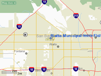
Rialto, California |
| Elevation AMSL |
1455 ft / 443 m |
| Coordinates |
34°07′46″N 117°24′06″W / 34.12944°N 117.40167°W / 34.12944; -117.40167Coordinates: 34°07′46″N 117°24′06″W / 34.12944°N 117.40167°W / 34.12944; -117.40167 |
| Runways |
| Direction |
Length |
Surface |
| ft |
m |
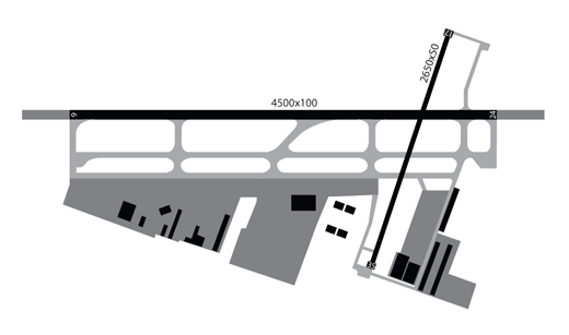
| 6/24 |
4,500 |
1,372 |
Asphalt |
| 17/35 |
2,650 |
808 |
Asphalt |
Transient Parking in front of the Art Scholl Aviation building. Rialto Municipal Airport (FAA LID: L67), originally called Miro Field, is a general aviation airport located three miles (5 km) northwest of the central business district (CBD) of the city of Rialto, in San Bernardino County, California, USA.
It is used exclusively by privately operated and chartered aircraft; no commercial airlines fly into this airport. The airport is located approximately eleven nautical miles northeast of Ontario International Airport and nine nautical miles west of San Bernardino International Airport. The airport does not have a control tower and, on average, handles 82 operations a day.
An FBO with a flight school and a separate helicopter flight school operate at the airport. There are several aviation related businesses on site. There is an air ambulance business in the southeast part of the airport.
Despite its above average size compared to other nearby airfields (Upland Cable Airport, Corona Municipal Airport, El Monte Municipal Airport, Redlands Municipal Airport and Hemet-Ryan Airport), Rialto is a relatively quiet and somewhat uneventful airport. This has led the city of Rialto to approve the closing of the airport by 2009/2010 for redevelopment of the property for other purposes driven by local real estate developers. History
The land which is now Rialto Airport, about 40 acres (160,000 m), was first purchased by Sam Miro in 1944. In 1966 the City of Rialto obtained the property while bringing the total land area to 60 acres (240,000 m).
In 1978 Art Scholl Aviation, founded by Art Scholl, relocated to Rialto Airport from nearby Flabob Airport in Riverside, California.
Since 1984 the City of Rialto has accepted more than USD$15 million in federal aid for airport improvement and land purchases.
Facilities
Rialto Municipal Airport covers 600 acres (243 ha) and has two asphalt paved runways: 6/24 measuring 4,500 x 100 ft. (1,372 x 30 m) and 17/35 measuring 2,650 x 50 ft. (808 x 15 m).
The above content comes from Wikipedia and is published under free licenses – click here to read more.
Location
& QuickFacts
|
FAA
Information Effective: |
2006-09-28 |
|
Airport
Identifier: |
L67 |
|
Longitude/Latitude: |
117-24-05.8690W/34-07-45.6370N
-117.401630/34.129344 (Estimated) |
|
Elevation: |
1455 ft / 443.48 m (Estimated) |
|
Land: |
600 acres |
|
From
nearest city: |
3 nautical miles NW of Rialto, CA |
|
Location: |
San Bernardino County, CA |
|
Magnetic Variation: |
14E (1985) |
Owner
& Manager
|
Ownership: |
Publicly
owned |
|
Owner: |
City Of Rialto |
|
Address: |
150 S Palm Ave
Rialto, CA 92376 |
|
Phone
number: |
909-820-2622 |
|
Manager: |
Richard M. Scanlan |
|
Address: |
150 S Palm Ave
Rialto, CA 92376 |
|
Phone number: |
909-820-2622 |
Airport Operations and Facilities
|
Airport
Use: |
Open
to public |
|
Wind
indicator: |
Yes |
|
Segmented Circle: |
Yes |
|
Control
Tower: |
No |
|
Attendance Schedule: |
ALL/ALL/0800-1700 |
|
Lighting
Schedule: |
DUSK-DAWN
ACTVT MIRL RYS 06/24 & 17/35; PAPI RY 24 & RY 35
- CTAF. |
|
Beacon
Color: |
Clear-Green (lighted land airport) |
|
Landing
fee charge: |
No |
|
Sectional chart: |
Los Angeles |
|
Region: |
AWP - Western-Pacific |
|
Boundary
ARTCC: |
ZLA - Los Angeles |
|
Tie-in
FSS: |
RAL - Riverside |
|
FSS
on Airport: |
No |
|
FSS
Phone: |
951-351-3020 |
|
FSS
Toll Free: |
1-800-WX-BRIEF |
|
NOTAMs
Facility: |
RAL (NOTAM-d service avaliable) |
|
Federal Agreements: |
NGY |
Airport Communications
|
CTAF: |
122.800 |
|
Unicom: |
122.800
|
Airport
Services
|
Fuel
available: |
100LLA |
|
Airframe
Repair: |
MAJOR |
|
Power
Plant Repair: |
MAJOR |
|
Bottled
Oxygen: |
LOW |
|
Bulk
Oxygen: |
NONE |
|
Runway Information
Runway 06/24
|
Dimension: |
4500 x 100 ft / 1371.6 x 30.5 m
RY 06/24 HAS 500 FT AREA EACH END OF RY |
|
Surface: |
ASPH, Good Condition |
|
Weight
Limit: |
Dual wheel: 60000 lbs. |
|
Edge
Lights: |
Medium
5 FOOT BRUSH COVERING RUNWAY LIGHTING |
|
|
Runway 06 |
Runway 24 |
|
Longitude: |
117-24-37.1680W |
117-23-46.1690W |
|
Latitude: |
34-07-38.5370N |
34-07-52.0360N |
|
Elevation: |
1445.00 ft |
1424.00 ft |
|
Alignment: |
72 |
127 |
|
Traffic
Pattern: |
Left |
Right |
|
Markings: |
Non-precision instrument, Fair Condition |
Non-precision instrument, Fair Condition |
|
Crossing
Height: |
0.00 ft |
40.00 ft |
|
VASI: |
|
2-light PAPI on left side |
|
Visual
Glide Angle: |
0.00� |
3.50� |
|
Runway
End Identifier: |
Yes |
Yes |
|
Runway 17/35
|
Dimension: |
2650 x 50 ft / 807.7 x 15.2 m
RY 06/24 HAS 500 FT AREA EACH END OF RY |
|
Surface: |
ASPH, Good Condition |
|
Weight
Limit: |
Single wheel: 12500 lbs. |
|
Edge
Lights: |
Medium
5 FOOT BRUSH COVERING RUNWAY LIGHTING |
|
|
Runway 17 |
Runway 35 |
|
Longitude: |
117-23-56.1450W |
117-23-55.9500W |
|
Latitude: |
34-07-59.4300N |
34-07-33.3740N |
|
Elevation: |
1448.00 ft |
1406.00 ft |
|
Alignment: |
127 |
127 |
|
Traffic
Pattern: |
Right |
Left |
|
Markings: |
Basic, Fair Condition |
Basic, Good Condition |
|
Crossing
Height: |
0.00 ft |
40.00 ft |
|
VASI: |
|
2-light PAPI on left side |
|
Visual
Glide Angle: |
0.00� |
3.50� |
|
Runway
End Identifier: |
No |
No |
|
Centerline
Lights: |
No |
No |
|
Touchdown
Lights: |
No |
No |
|
Obstruction: |
80 ft trees, 900.0 ft from runway, 120 ft right
of centerline, 8:1 slope to clear
5 FOOT BRUSH COVERING RUNWAY OBJECT FREE AREA |
, 50:1 slope to clear |
|
Radio Navigation
Aids
|
ID |
Type |
Name |
Ch |
Freq |
Var |
Dist |
|
SB |
NDB |
Petis |
|
397.00 |
14E |
4.7 nm |
|
SJY |
NDB |
San Jacinto |
|
227.00 |
14E |
28.4 nm |
|
EMT |
NDB |
El Monte |
|
359.00 |
15E |
31.4 nm |
|
CPM |
NDB |
Compton |
|
378.00 |
15E |
44.5 nm |
|
RIV |
TACAN |
March |
077X |
|
14E |
14.8 nm |
|
RAL |
VOR |
Riverside |
|
112.40 |
15E |
10.9 nm |
|
HDF |
VOR |
Homeland |
|
113.40 |
14E |
23.8 nm |
|
VCV |
VOR/DME |
Victorville |
031X |
109.40 |
14E |
27.9 nm |
|
ELB |
VOR/DME |
El Toro |
119X |
117.20 |
14E |
31.8 nm |
|
PDZ |
VORTAC |
Paradise |
059X |
112.20 |
15E |
14.2 nm |
|
POM |
VORTAC |
Pomona |
041X |
110.40 |
15E |
19.4 nm |
|
SLI |
VORTAC |
Seal Beach |
104X |
115.70 |
15E |
38.6 nm |
|
PMD |
VORTAC |
Palmdale |
092X |
114.50 |
15E |
44.6 nm |
|
SNA |
VOT |
Santa Ana |
|
110.00 |
|
35.9 nm |
Remarks
- AFT
DEP NO TURN BLO 2455 FT MSL; HELICOPTERS MAINTAIN 2000 FT MSL UNTIL
N OF BASE LINE ROAD; FOR CLSD PATTERN REMAIN N OF BASE LINE ROAD.
- AVOID
OVERFLYING RESIDENTIAL AREAS WEST OF ARPT FOR NOISE ABATEMENT.
- AVOID
OVERFLYING SCHOOLS .5 MILE EAST OF ARPT ON TURN FM DOWNWIND TO BASE.
Based Aircraft
|
Aircraft
based on field: |
251 |
|
Single
Engine Airplanes: |
215 |
|
Multi
Engine Airplanes: |
10 |
|
Helicopters: |
25 |
|
Ultralights: |
1 |
Operational Statistics
|
Aircraft
Operations: |
83/Day |
|
General
Aviation Local: |
73.3% |
|
General
Aviation Itinerant: |
26.7% |
Rialto Municipal /miro Fld/ Airport
Address:
San Bernardino County, CA
Tel:
909-820-2622
Images
and information placed above are from
http://www.airport-data.com/airport/L67/
We
thank them for the data!
| General
Info |
| Country |
United
States |
| State |
CALIFORNIA
|
| FAA ID |
L67
|
| Latitude |
34-07-45.637N
|
| Longitude |
117-24-05.869W
|
| Elevation |
1455 feet
|
| Near City |
RIALTO
|
We don't guarantee the information is fresh and accurate. The data may
be wrong or outdated.
For more up-to-date information please refer to other sources.
|
|


