 |
|
Reedley Municipal Airport |
| Reedley Municipal Airport |
| IATA: none – ICAO: none – FAA LID: O32 |
| Summary |
| Airport type |
Public |
| Operator |
City of Reedley |
| Location |
Reedley, California |
| Elevation AMSL |
383 ft / 116.7 m |
| Coordinates |
36°39′59″N 119°26′59″W / 36.66639°N 119.44972°W / 36.66639; -119.44972Coordinates: 36°39′59″N 119°26′59″W / 36.66639°N 119.44972°W / 36.66639; -119.44972 |
| Runways |
| Direction |
Length |
Surface |
| ft |
m |
| 15/33 |
3,300 |
1,006 |
Asphalt |
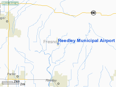
Reedley Municipal Airport (FAA LID: O32) is a public airport located four miles (6.4 km) north of Reedley, serving Fresno County, California, USA. This general aviation airport covers 138 acres (56 ha) and has one runway.
The above content comes from Wikipedia and is published under free licenses – click here to read more.
Location
& QuickFacts
|
FAA
Information Effective: |
2006-09-28 |
|
Airport
Identifier: |
O32 |
|
Longitude/Latitude: |
119-26-59.4540W/36-39-58.8210N
-119.449848/36.666339 (Estimated) |
|
Elevation: |
383 ft / 116.74 m (Estimated) |
|
Land: |
138 acres |
|
From
nearest city: |
4 nautical miles N of Reedley, CA |
|
Location: |
Fresno County, CA |
|
Magnetic Variation: |
15E (1985) |
Owner
& Manager
|
Ownership: |
Publicly owned |
|
Owner: |
City Of Reedley |
|
Address: |
100 N. East Ave
Reedley, CA 93654 |
|
Phone number: |
209-637-4203 |
|
Manager: |
Rocky Rogers |
|
Address: |
1733 9th Street
Reedley, CA 93654 |
|
Phone number: |
559-637-4200
X 213. |
Airport
Operations and Facilities
|
Airport
Use: |
Open to public |
|
Wind
indicator: |
Yes |
|
Segmented
Circle: |
Yes |
|
Control
Tower: |
No |
|
Attendance
Schedule: |
ALL/MON-FRI/0800-1700 |
|
Lighting
Schedule: |
DUSK-DAWN
ACTVT MIRL RY 15/33; REIL RYS 15 & 33; PAPI RYS 15 &
33 AND TWY LGTS - CTAF. |
|
Beacon
Color: |
Clear-Green (lighted land airport) |
|
Landing
fee charge: |
No |
|
Sectional
chart: |
San Francisco |
|
Region: |
AWP - Western-Pacific |
|
Traffic
Pattern Alt: |
1000 ft |
|
Boundary
ARTCC: |
ZOA - Oakland |
|
Tie-in
FSS: |
RIU - Rancho Murieta |
|
FSS
on Airport: |
No |
|
FSS
Phone: |
916-354-0161 |
|
FSS
Toll Free: |
1-800-WX-BRIEF |
|
NOTAMs
Facility: |
RIU (NOTAM-d service avaliable) |
|
Federal Agreements: |
NGY |
Airport
Communications
|
CTAF: |
122.700 |
|
Unicom: |
122.700 |
Airport
Services
|
Fuel
available: |
100LLA
FUEL AVBL 24 HRS COMPUTERIZED CREDIT CARD. |
|
Airframe
Repair: |
MAJOR |
|
Power
Plant Repair: |
MAJOR |
|
Bottled
Oxygen: |
NONE |
|
Bulk
Oxygen: |
NONE |
|
Runway Information
Runway 15/33
|
Dimension: |
3300 x 60 ft / 1005.8 x 18.3 m |
|
Surface: |
ASPH, Good Condition |
|
Weight
Limit: |
Single wheel: 12000 lbs. |
|
Edge
Lights: |
Medium |
|
|
Runway 15 |
Runway 33 |
|
Elevation: |
385.00 ft |
379.00 ft |
|
Traffic
Pattern: |
Left |
Right |
|
Markings: |
Basic, Poor Condition |
Basic, Poor Condition |
|
Crossing
Height: |
41.00 ft |
49.00 ft |
|
VASI: |
2-light PAPI on left side |
2-light PAPI on right side |
|
Visual
Glide Angle: |
3.00� |
4.00� |
|
Runway
End Identifier: |
Yes |
Yes |
|
Centerline
Lights: |
No |
No |
|
Touchdown
Lights: |
No |
No |
|
Obstruction: |
12 ft trees, 450.0 ft from runway, 60 ft left
of centerline, 20:1 slope to clear |
75 ft tree, 1800.0 ft from runway, 50 ft right
of centerline, 21:1 slope to clear |
|
Radio Navigation
Aids
|
ID |
Type |
Name |
Ch |
Freq |
Var |
Dist |
|
CUK |
NDB |
Academy |
|
266.00 |
14E |
9.7 nm |
|
FCH |
NDB |
Chandler |
|
344.00 |
15E |
18.8 nm |
|
COR |
NDB |
Salyer Farms |
|
205.00 |
16E |
36.3 nm |
|
NLC |
TACAN |
Lemoore |
080X |
|
16E |
31.6 nm |
|
VIS |
VOR/DME |
Visalia |
031X |
109.40 |
16E |
18.0 nm |
|
TTE |
VOR/DME |
Tule |
029X |
109.20 |
16E |
49.8 nm |
|
CZQ |
VORTAC |
Clovis |
076X |
112.90 |
15E |
21.9 nm |
|
FRA |
VORTAC |
Friant |
103X |
115.60 |
17E |
27.2 nm |
Remarks
- RY
15/33 PAEW ADJ RY 1500-1900 EVERY MONDAY.
Based Aircraft
|
Aircraft
based on field: |
74 |
|
Single
Engine Airplanes: |
68 |
|
Multi
Engine Airplanes: |
1 |
|
Ultralights: |
5 |
Operational Statistics
|
Aircraft
Operations: |
91/Day |
|
General
Aviation Local: |
60.6% |
|
General
Aviation Itinerant: |
39.4% |
Reedley Municipal Airport
Address:
Fresno County, CA
Tel:
209-637-4203, 559-637-4200
Images
and information placed above are from
http://www.airport-data.com/airport/O32/
We
thank them for the data!
| General
Info |
| Country |
United
States |
| State |
CALIFORNIA
|
| FAA ID |
O32
|
| Latitude |
36-39-58.821N
|
| Longitude |
119-26-59.454W
|
| Elevation |
383 feet
|
| Near City |
REEDLEY
|
We don't guarantee the information is fresh and accurate. The data may
be wrong or outdated.
For more up-to-date information please refer to other sources.
|
|


