 |
|
Red Bluff Municipal Airport |
| Red Bluff Municipal Airport |
| IATA: none – ICAO: none – FAA LID: RBL |
| Summary |
| Airport type |
Public |
| Operator |
City of Red Bluff |
| Location |
Red Bluff, California |
| Elevation AMSL |
352 ft / 107 m |
| Coordinates |
40°09′03″N 122°15′08″W / 40.15083°N 122.25222°W / 40.15083; -122.25222Coordinates: 40°09′03″N 122°15′08″W / 40.15083°N 122.25222°W / 40.15083; -122.25222 |
| Runways |
| Direction |
Length |
Surface |
| ft |
m |
| 16/34 |
5,700 |
1737 |
Asphalt |
Red Bluff Municipal Airport (FAA LID: RBL) is a public airport located two miles (1.6 km) south of Red Bluff, serving Tehama County, California, USA. The airport is mostly used for general aviation.
Facilities
Red Bluff Municipal Airport covers 602 acres (244 ha) and has one asphalt paved runway (16/34) measuring 5,700 x 100 ft. (1,737 x 30 m). This land was purchased from Tyler Graham in the late 1950s. The airport is built upon an Indian Graveyard and is believed to be haunted.
The above content comes from Wikipedia and is published under free licenses – click here to read more.
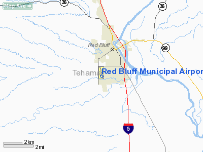
Location
& QuickFacts
|
FAA
Information Effective: |
2006-09-28 |
|
Airport
Identifier: |
RBL |
|
Longitude/Latitude: |
122-15-08.3000W/40-09-02.5000N
-122.252306/40.150694 (Estimated) |
|
Elevation: |
352 ft / 107.29 m (Surveyed) |
|
Land: |
602 acres |
|
From
nearest city: |
2 nautical miles S of Red Bluff, CA |
|
Location: |
Tehama County, CA |
|
Magnetic Variation: |
17E (1985) |
Owner
& Manager
|
Ownership: |
Publicly owned |
|
Owner: |
City Of Red Bluff |
|
Address: |
555 Washington St
Red Bluff, CA 96080 |
|
Phone
number: |
530-527-2605 |
|
Manager: |
Gary Antone
DIRECTOR OF PUBLIC WORKS. |
|
Address: |
555 Washington St
Red Bluff, CA 96080 |
|
Phone number: |
530-527-2605
CITY HALL. |
Airport
Operations and Facilities
|
Airport
Use: |
Open to public |
|
Wind
indicator: |
Yes |
|
Segmented
Circle: |
Yes |
|
Control
Tower: |
No |
|
Attendance
Schedule: |
ALL/ALL/0700-DUSK |
|
Lighting
Schedule: |
DUSK-DAWN
ACTVT MIRL RY 15/33, VASI RY 15 & RY 33 - CTAF. |
|
Beacon
Color: |
Clear-Green (lighted land airport) |
|
Landing
fee charge: |
No |
|
Sectional
chart: |
Klamath Falls |
|
Region: |
AWP - Western-Pacific |
|
Traffic
Pattern Alt: |
1000 ft |
|
Boundary
ARTCC: |
ZOA - Oakland |
|
Tie-in
FSS: |
RIU - Rancho Murieta |
|
FSS
on Airport: |
No |
|
FSS
Phone: |
916-354-0161 |
|
FSS
Toll Free: |
1-800-WX-BRIEF |
|
NOTAMs
Facility: |
RBL (NOTAM-d service avaliable) |
|
Federal Agreements: |
NGRY |
Airport
Communications
|
CTAF: |
123.000 |
|
Unicom: |
123.000 |
Airport
Services
|
Fuel
available: |
100LL80 A
AUTOMATED CREDIT CARD FUEL SYSTEM 24 HRS. |
|
Airframe
Repair: |
MAJOR |
|
Power
Plant Repair: |
MAJOR |
|
Bottled
Oxygen: |
NONE |
|
Bulk
Oxygen: |
NONE |
|
Runway Information
Runway 15/33
|
Dimension: |
5700 x 100 ft / 1737.4 x 30.5 m |
|
Surface: |
ASPH, Good Condition |
|
Weight
Limit: |
Single wheel: 30000 lbs.
Dual wheel: 65000 lbs. |
|
Edge
Lights: |
Medium |
|
|
Runway 15 |
Runway 33 |
|
Longitude: |
122-15-15.8354W |
122-15-00.7077W |
|
Latitude: |
40-09-30.0062N |
40-08-34.8844N |
|
Elevation: |
347.00 ft |
343.00 ft |
|
Alignment: |
127 |
127 |
|
Traffic
Pattern: |
Right |
Left |
|
Markings: |
Non-precision instrument, Good Condition |
Non-precision instrument, Good Condition |
|
Crossing
Height: |
40.00 ft |
40.00 ft |
|
VASI: |
4-box on left side |
4-box on left side |
|
Visual
Glide Angle: |
3.00� |
3.00� |
|
Runway
End Identifier: |
Yes |
Yes |
|
Centerline
Lights: |
No |
No |
|
Touchdown
Lights: |
No |
No |
|
Radio Navigation
Aids
|
ID |
Type |
Name |
Ch |
Freq |
Var |
Dist |
|
PBT |
NDB |
Proberta |
|
338.00 |
16E |
2.3 nm |
|
OVE |
NDB |
Oroville |
|
212.00 |
16E |
49.0 nm |
|
RDD |
VOR/DME |
Redding |
021X |
108.40 |
18E |
21.3 nm |
|
CIC |
VOR/DME |
Chico |
035X |
109.80 |
16E |
28.6 nm |
|
RBL |
VORTAC |
Red Bluff |
104X |
115.70 |
18E |
3.2 nm |
Remarks
- TXY
SYSTEM HAS HWY TYPE EDGE REFLECTORS.
- TRAFFIC
PATTERN ALTITUDES: 1500' AGL TURBO OPERATIONS; 1000' AGL - OTHERS.
- ULTRALIGHT
ACTIVITY ON AND INVOF ARPT.
- RY
15 CALM WIND RUNWAY.
Based Aircraft
|
Aircraft
based on field: |
67 |
|
Single
Engine Airplanes: |
55 |
|
Multi
Engine Airplanes: |
4 |
|
Jet Engine
Airplanes: |
2 |
|
Helicopters: |
5 |
|
Gliders: |
1 |
Operational Statistics
|
Aircraft
Operations: |
72/Day |
|
Air Taxi: |
3.8% |
|
General
Aviation Local: |
38.2% |
|
General
Aviation Itinerant: |
57.4% |
|
Military: |
0.6% |
Red Bluff Municipal Airport
Address:
Tehama County, CA
Tel:
530-527-2605
Images
and information placed above are from
http://www.airport-data.com/airport/RBL/
We
thank them for the data!
| General
Info |
| Country |
United
States |
| State |
CALIFORNIA
|
| FAA ID |
RBL
|
| Latitude |
40-09-02.364N
|
| Longitude |
122-15-08.245W
|
| Elevation |
349 feet
|
| Near City |
RED BLUFF
|
We don't guarantee the information is fresh and accurate. The data may
be wrong or outdated.
For more up-to-date information please refer to other sources.
|
|


