 |
|
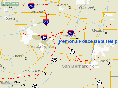
Pomona Police Dept Heliport |
|
|
Location
& QuickFacts
|
FAA
Information Effective: |
2006-09-28 |
|
Airport
Identifier: |
98L |
|
Longitude/Latitude: |
117-47-36.2100W/34-03-09.0380N
-117.793392/34.052511 (Estimated) |
|
Elevation: |
1001 ft / 305.10 m (Estimated) |
|
Land: |
0 acres |
|
From
nearest city: |
0 nautical miles N of Pomona, CA |
|
Location: |
Los Angeles County, CA |
|
Magnetic Variation: |
14E (1985) |
Owner
& Manager
|
Ownership: |
Publicly owned |
|
Owner: |
City Of Pomona |
|
Address: |
1905 Mc Kinley, Brackett Fld
La Verne, CA 91750 |
|
Phone
number: |
714-620-2100 |
|
Manager: |
Sgt. Larry Zambrano
CHIEF PILOT. |
|
Address: |
490 W Mission Blvd
Pomona, CA 91766 |
|
Phone number: |
714-620-2100 |
Airport
Operations and Facilities
|
Airport
Use: |
Private |
|
Wind
indicator: |
Yes |
|
Segmented
Circle: |
No |
|
Control
Tower: |
No |
|
Attendance
Schedule: |
ALL/ALL/ALL |
|
Lighting
Schedule: |
PHONE REQ
FOR RWY LGTS, PHONE 714-620-2100. |
|
Landing fee charge: |
No |
|
Sectional chart: |
Los Angeles |
|
Region: |
AWP - Western-Pacific |
|
Boundary ARTCC: |
ZLA - Los Angeles |
|
Tie-in FSS: |
RAL - Riverside |
|
FSS on Airport: |
No |
|
FSS Phone: |
951-351-3020 |
|
FSS Toll Free: |
1-800-WX-BRIEF |
Airport
Services
|
Fuel
available: |
100 |
|
Airframe
Repair: |
NONE |
|
Power
Plant Repair: |
NONE |
|
Runway Information
Helipad H1
|
Dimension: |
125 x 100 ft / 38.1 x 30.5 m |
|
Surface: |
ASPH, |
|
Edge
Lights: |
Low |
|
|
Runway H1 |
Runway |
|
Traffic
Pattern: |
Left |
Left |
|
Radio Navigation
Aids
|
ID |
Type |
Name |
Ch |
Freq |
Var |
Dist |
|
EMT |
NDB |
El Monte |
|
359.00 |
15E |
12.0 nm |
|
SB |
NDB |
Petis |
|
397.00 |
14E |
21.3 nm |
|
CPM |
NDB |
Compton |
|
378.00 |
15E |
24.7 nm |
|
PAI |
NDB |
Pacoima |
|
370.00 |
15E |
33.3 nm |
|
SJY |
NDB |
San Jacinto |
|
227.00 |
14E |
42.5 nm |
|
GWF |
NDB |
Gen William J Fox |
|
282.00 |
15E |
46.3 nm |
|
RIV |
TACAN |
March |
077X |
|
14E |
27.3 nm |
|
RAL |
VOR |
Riverside |
|
112.40 |
15E |
18.2 nm |
|
HDF |
VOR |
Homeland |
|
113.40 |
14E |
34.6 nm |
|
ELB |
VOR/DME |
El Toro |
119X |
117.20 |
14E |
22.8 nm |
|
SMO |
VOR/DME |
Santa Monica |
045X |
110.80 |
15E |
33.1 nm |
|
VNY |
VOR/DME |
Van Nuys |
078X |
113.10 |
15E |
36.2 nm |
|
VCV |
VOR/DME |
Victorville |
031X |
109.40 |
14E |
38.2 nm |
|
POM |
VORTAC |
Pomona |
041X |
110.40 |
15E |
1.6 nm |
|
PDZ |
VORTAC |
Paradise |
059X |
112.20 |
15E |
15.4 nm |
|
SLI |
VORTAC |
Seal Beach |
104X |
115.70 |
15E |
20.8 nm |
|
LAX |
VORTAC |
Los Angeles |
083X |
113.60 |
15E |
32.6 nm |
|
PMD |
VORTAC |
Palmdale |
092X |
114.50 |
15E |
37.3 nm |
|
SNA |
VOT |
Santa Ana |
|
110.00 |
|
22.9 nm |
|
LAX |
VOT |
San Pedro Hill |
|
113.90 |
|
32.8 nm |
Remarks
Based Aircraft
|
Aircraft
based on field: |
2 |
|
Single
Engine Airplanes: |
1 |
|
Helicopters: |
1 |
Pomona Police Dept Heliport
Address:
Los Angeles County, CA
Tel:
714-620-2100
Images
and information placed above are from
http://www.airport-data.com/airport/98L/
We
thank them for the data!
| General
Info |
| Country |
United
States |
| State |
CALIFORNIA
|
| FAA ID |
98L
|
| Latitude |
34-03-09.038N
|
| Longitude |
117-47-36.210W
|
| Elevation |
1001 feet
|
| Near City |
POMONA
|
We don't guarantee the information is fresh and accurate. The data may
be wrong or outdated.
For more up-to-date information please refer to other sources.
|
|


