 |
|
|
|
|
|
Location
& QuickFacts
|
FAA
Information Effective: |
2006-09-28 |
|
Airport
Identifier: |
25CN |
|
Longitude/Latitude: |
119-54-21.4970W/34-23-22.9830N
-119.905971/34.389717 (Estimated) |
|
Elevation: |
87 ft / 26.52 m (Estimated) |
|
Land: |
0 acres |
|
From
nearest city: |
2 nautical miles SW of Ellwood, CA |
|
Location: |
Santa Barbara County, CA |
|
Magnetic Variation: |
14E (1985) |
Owner
& Manager
|
Ownership: |
Privately owned |
|
Owner: |
Mobile Oil Corp |
|
Address: |
Po Box 9989
Bakersfield, CA 93389 |
|
Phone number: |
805-968-4602 |
|
Manager: |
Ron W. Mauley |
|
Address: |
Rt 1, Box 275
Goleta, CA 93117 |
|
Phone number: |
805-968-1697 |
Airport
Operations and Facilities
|
Airport
Use: |
Private |
|
Wind
indicator: |
Yes
WIND SOCK WEST SIDE OF PLATFORM; RED & BLUE LIGHT. |
|
Segmented Circle: |
No |
|
Control Tower: |
No |
|
Attendance Schedule: |
ALL/ALL/ALL |
|
Lighting Schedule: |
DUSK-DAWN |
|
Landing fee charge: |
No |
|
Sectional chart: |
Los Angeles |
|
Region: |
AWP - Western-Pacific |
|
Boundary ARTCC: |
ZLA - Los Angeles |
|
Tie-in FSS: |
HHR - Hawthorne |
|
FSS on Airport: |
No |
|
FSS Phone: |
310-970-0102 |
|
FSS Toll Free: |
1-800-WX-BRIEF |
Airport
Services
|
Airframe
Repair: |
NONE |
|
Power
Plant Repair: |
NONE |
|
Runway Information
Helipad H1
|
Dimension: |
45 x 45 ft / 13.7 x 13.7 m |
|
Surface: |
ASPH,
NON-SKID OVER STEEL DECK. |
|
|
Runway H1 |
Runway |
|
Traffic
Pattern: |
Left |
Left |
|
Radio Navigation
Aids
|
ID |
Type |
Name |
Ch |
Freq |
Var |
Dist |
|
VBG |
TACAN |
Vandenberg |
059Y |
|
15E |
39.3 nm |
|
NTD |
TACAN |
Point Mugu |
043X |
|
15E |
42.1 nm |
|
GLJ |
VOR |
Guadalupe |
|
111.00 |
16E |
45.5 nm |
|
CMA |
VOR/DME |
Camarillo |
105X |
115.80 |
15E |
41.7 nm |
|
VTU |
VOR/DME |
Ventura |
019X |
108.20 |
15E |
45.6 nm |
|
RZS |
VORTAC |
San Marcus |
096X |
114.90 |
14E |
9.8 nm |
|
GVO |
VORTAC |
Gaviota |
085X |
113.80 |
16E |
12.5 nm |
|
FLW |
VORTAC |
Fellows |
122X |
117.50 |
16E |
42.3 nm |
Remarks
- (E3A)
ADDNL PHONE NR TO HHR FSS 1-WX-BRIEF.
- PVT
USE.
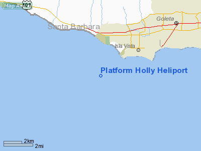
Platform Holly Heliport
Address:
Santa Barbara County, CA
Tel:
805-968-4602, 805-968-1697
Images
and information placed above are from
http://www.airport-data.com/airport/25CN/
We
thank them for the data!
| General
Info |
| Country |
United
States |
| State |
CALIFORNIA
|
| FAA ID |
25CN
|
| Latitude |
34-23-22.983N
|
| Longitude |
119-54-21.497W
|
| Elevation |
87 feet
|
| Near City |
ELLWOOD
|
We don't guarantee the information is fresh and accurate. The data may
be wrong or outdated.
For more up-to-date information please refer to other sources.
|
|


