 |
|
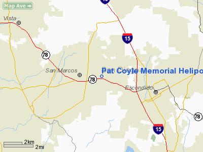
Pat Coyle Memorial Heliport |
|
|
Location
& QuickFacts
|
FAA
Information Effective: |
2006-09-28 |
|
Airport
Identifier: |
4CL6 |
|
Longitude/Latitude: |
117-08-44.0000W/33-08-31.0000N
-117.145556/33.141944 (Estimated) |
|
Elevation: |
600 ft / 182.88 m (Estimated) |
|
Land: |
0 acres |
|
From
nearest city: |
0 nautical miles N of San Marcos, CA |
|
Location: |
San Diego County, CA |
|
Magnetic
Variation: |
13E (1995) |
Owner
& Manager
|
Ownership: |
Privately owned |
|
Owner: |
San Diego County Sheriff's Dept. |
|
Address: |
1745 N. Marshall Avenue
El Cajon, CA 92020 |
|
Phone
number: |
619-448-2068 |
|
Manager: |
Lt. R. W. Curry |
|
Address: |
1745 N. Marshall Avenue
El Cajon, CA 92020 |
|
Phone number: |
619-448-2068 |
Airport
Operations and Facilities
|
Airport
Use: |
Private |
|
Wind
indicator: |
Yes |
|
Segmented
Circle: |
No |
|
Control
Tower: |
No |
|
Attendance
Schedule: |
UNATNDD |
|
Lighting
Schedule: |
RDO-CTL
ACTVT RY H1 PERIMETER LGTS, WINDSOCK - 123.1. |
|
Sectional
chart: |
Los Angeles |
|
Region: |
AWP - Western-Pacific |
|
Boundary
ARTCC: |
ZLA - Los Angeles |
|
Tie-in
FSS: |
SAN - San Diego |
|
FSS
Phone: |
858-277-7043 |
|
FSS
Toll Free: |
1-800-WX-BRIEF |
|
Runway Information
Helipad H1
|
Dimension: |
26
x 26 ft / 7.9 x 7.9 m |
|
Surface: |
CONC, |
|
|
Runway H1 |
Runway |
|
Traffic
Pattern: |
Left |
Left |
|
Radio Navigation
Aids
|
ID |
Type |
Name |
Ch |
Freq |
Var |
Dist |
|
SAN |
FAN MARKER |
Encat |
|
|
15E |
26.1 nm |
|
UN |
NDB |
Tijuana |
|
381.00 |
14E |
37.0 nm |
|
SJY |
NDB |
San Jacinto |
|
227.00 |
14E |
39.9 nm |
|
NFG |
TACAN |
Camp Pendleton |
055X |
|
13E |
14.5 nm |
|
NKX |
TACAN |
Miramar |
033X |
|
15E |
16.4 nm |
|
NZY |
TACAN |
North Island |
117X |
|
14E |
26.6 nm |
|
NRS |
TACAN |
Imperial Beach |
029X |
|
14E |
34.8 nm |
|
RIV |
TACAN |
March |
077X |
|
14E |
46.4 nm |
|
NKX |
UHF/NDB |
Miramar |
|
352.00 |
15E |
16.1 nm |
|
HDF |
VOR |
Homeland |
|
113.40 |
14E |
38.2 nm |
|
TIJ |
VOR/DME |
Tijuana |
112X |
116.50 |
14E |
37.4 nm |
|
ELB |
VOR/DME |
El Toro |
119X |
117.20 |
14E |
43.5 nm |
|
OCN |
VORTAC |
Oceanside |
100X |
115.30 |
15E |
14.9 nm |
|
MZB |
VORTAC |
Mission Bay |
125X |
117.80 |
15E |
22.0 nm |
|
JLI |
VORTAC |
Julian |
087X |
114.00 |
15E |
28.2 nm |
|
PGY |
VORTAC |
Poggi |
035X |
109.80 |
14E |
33.0 nm |
|
SAN |
VOT |
Mount Soledad |
|
109.00 |
|
19.0 nm |
|
SEE |
VOT |
Gillespie Field |
|
110.00 |
|
20.9 nm |
|
SNA |
VOT |
Santa Ana |
|
110.00 |
|
48.5 nm |
Remarks
- FINAL
APCH & TKOF AREA 48 FT SQUARE, TOUCHDOWN AND LIFT-OFF AREA 26 FT
DIAMETER CIRCLE.
- PROVIDED
VFR, PRIVATE USE, INSTALL LIGHTING IN ACCORDANCE WITH AC150/5390-2 IF
NIGHT OPNS ARE CONDUCTED.
Pat Coyle Memorial Heliport
Address: San Diego County, CA
Tel:
619-448-2068
Images
and information placed above are from
http://www.airport-data.com/airport/4CL6/
We
thank them for the data!
| General
Info |
| Country |
United
States |
| State |
CALIFORNIA
|
| FAA ID |
4CL6
|
| Latitude |
33-08-31.000N
|
| Longitude |
117-08-44.000W
|
| Elevation |
600 feet
|
| Near City |
SAN MARCOS
|
We don't guarantee the information is fresh and accurate. The data may
be wrong or outdated.
For more up-to-date information please refer to other sources.
|
|


