|
 |
|
||||
|
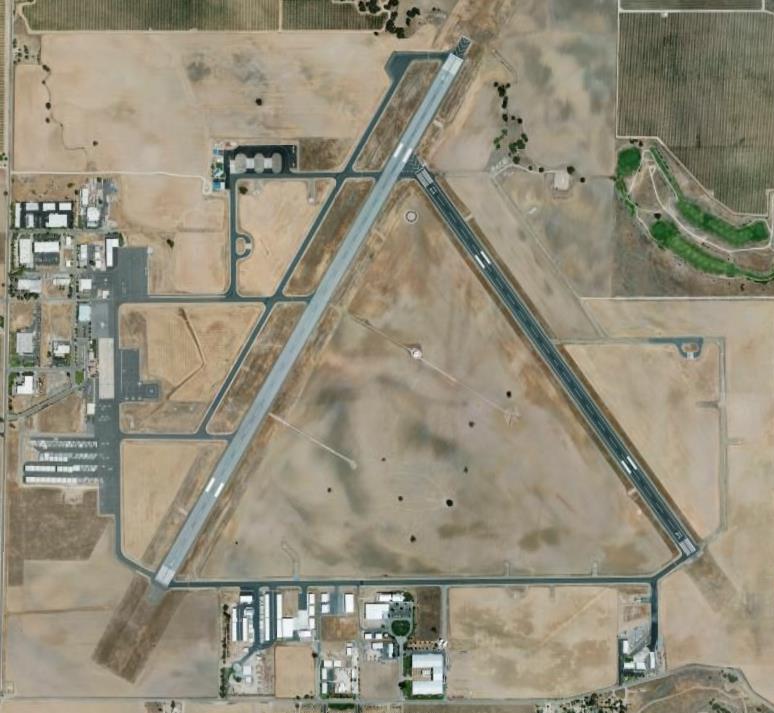
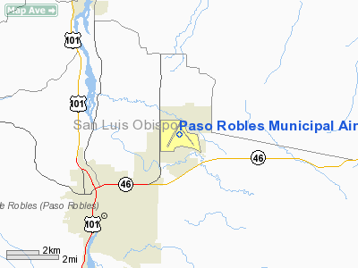
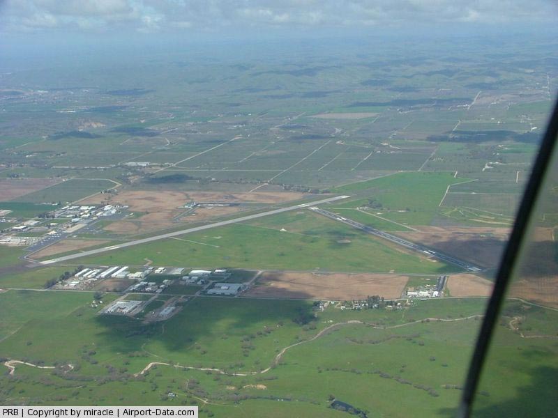
Paso Robles Municipal Airport (IATA: PRB, ICAO: KPRB, FAA LID: PRB) is a public airport located four miles (6 km) northeast of the central business district of Paso Robles, a city in San Luis Obispo County, California, United States. This general aviation airport is publicly owned by City of Paso Robles. FacilitiesPaso Robles Municipal Airport covers an area of 1,300 acres (5.3 km²) and contains two runways:
HistoryThe Paso Robles Municipal Airport is a 1,300-acre (530 ha) site approximately 4 miles (6.4 km) northeast of downtown Paso Robles. Originally constructed in 1943 as the Estrella Army Air Field, the airport plays its own part in the history of aviation in the local area. It saw little military activity during the War, but its advent paved the way for the future of aviation in the area. Sherwood Field, located a few miles to the south, generally played a more colorful role in the beginnings of aviation in Northern San Luis Obispo County. On September 3, 1942 construction began on the Airfield, which was to be used as a Marine Corps Bomber Base. On April 8, 1943, the field was dedicated as Estrella Army Airfield to be used by the Army Air Corps. Estrella Army Airfield consisted of 1259 acres of land, two 4,700-foot-long (1,400 m) runways, an operations building and a small, three-bay fire station. The Marine Corps Units occupied buildings to the west, across Airport Road in what is now the California Youth Authority. On August 29, 1947 the Federal Government transferred 1,057 acres (4.28 km) to the County of San Luis Obispo to be used as a commercial airport, and 202 acres (0.82 km) and buildings to the State of California to be used as a correctional facility After the county's acquisition of the airfield, the County of San Luis Obispo extended runway 01/19 from 4,700 feet (1,400 m) to 6,009 feet (1,832 m); installed high intensity lights; and built a large hangar, ten T-Hangars and a terminal building between 1949 and 1952. In 1952 commercial air service for San Luis Obispo County began, with Southwest Airways serving the area, which became Pacific Airlines, and later yet merged into Hughes Air West. This service continued until 1974, when the commercial air service at San Luis Obispo County Airport grew heavier and the county determined it wasn't necessary to have commercial air service at two airports that were located just 25 miles (40 km) from one another. Immediately following the termination of commercial service at Estrella Airfield in 1973, the county, in an effort to rid its rolls of excess property, sold the air base to the City of Paso Robles for $1.00. At that time the County was unable to derive enough income to support the cost of running the airport, and the Estrella Army Air Force Base then officially became the town's municipal airport. After Estrella Field was transferred to the City of Paso Robles in 1973, industrial and General aviation development has seen an astonishing amount of continued growth. After the airfield was turned over for civilian use, it was initially named Archie Dean Field, but soon after acquired its current name of Paso Robles Municipal. The City of Paso Robles subdivided unused land into 81 parcels for commercial development. The City formed an all-volunteer Fire, Crash and Rescue Department to serve the airport and the surrounding area. The City took over the water wells and the sewer treatment plant from the State to serve both the Airport and the Youth Authority. Current operationsCurrently, there is no scheduled passenger airline service at the airport. The last carrier terminated its local operations in the early 1970s in the wake of federal deregulation. Although Paso Robles Airport does not currently offer scheduled passenger service, they do however have a large amount of daily business aviation operations, in addition to serving as a large general aviation base. The California Department of Forestry (CDF) operates an Air Attack Base at the airport, which provides major fire protection for three counties (San Luis Obispo, Kern and Monterey) and the 5,800,000 acres (23,500 km) of wildland area in this part of Central California that encompass them. At the base, aircraft are loaded and reloaded with fire fighting retardant chemicals, such as Phos chek, which are dropped on brush and forest fires in the surrounding regions. Also, the California Highway Patrol (CHP) Air Operations Division house a fixed wing aircraft, used for speed enforcement, as well as a helicopter, used for search and rescue missions in the area. This local Air Operations Division also provides a variety of search, patrol and enforcement services for the local communities. The airport also serves as a support facility for three local military installations; Camp Roberts, Fort Hunter-Liggett, and Camp San Luis Obispo. In addition to these fixed operators, many military, air charter, corporate, air ambulance, and other flying services operate from the airport on a regular basis. The area immediately surrounding the Paso Robles Airport, known as Airport Road Industrial Park, is also home to many aviation maintenance providers and facilities, as well as many aviation parts manufacturers and other related businesses. Under the City’s direction, sections of the industrial park have been developed with utilities and infrastructure improvements. Aircraft hangar and aviation service facilities have been constructed. In 1973, there were just four businesses employing 22 people on the airport. Today, there is just over 500,000 square feet (46,000 m) of industrial building space in operation on the airport, now housing nearly 50 individual businesses, and providing over 700 jobs in the community. The number of aircraft based at the airport has grown from 55 at the time of City acquisition in 1973 to around 220, today. Located approximately halfway between Los Angeles and San Francisco, the airport has a service area of over 2,000 square miles in northern San Luis Obispo and southern Monterey counties. Future expansion plansPhase 2 (2008-2012)
Phase 3 (2013-2020)
Fixed base operators
Other airport businesses
Image galleryThe above content comes from Wikipedia and is published under free licenses – click here to read more.
Runway InformationRunway 01/19
Runway 13/31
Helipad H1
Radio Navigation Aids
Paso Robles Municipal Airport Address: San Luis Obispo County, CA Tel: 805-237-3861, 805-237-3877 Images
and information placed above are from We thank them for the data!
We don't guarantee the information is fresh and accurate. The data may
be wrong or outdated. |
|||||||||||||||||||||||||||||||||||||||||||||||||||||||||||||||||||||||||||||||||||||||||||||||||||||||||||||||||||||||||||||||||||||||||||||||||||||||||||||||||||||||||||||||||||||||||||||||||||||||||||||||||||||||||||||||||||||||||||||||||||||||||||||||||||||||||||||||||||||||||||||||||||||||||||||||||||||||||||||||||||||||||||||||||||||||||||||||||||||||||

 |
|
Copyright 2004-2026 © by Airports-Worldwide.com, Vyshenskoho st. 36, Lviv 79010, Ukraine Legal Disclaimer |