 |
|
|
|
|
|
Location
& QuickFacts
|
FAA
Information Effective: |
2006-09-28 |
|
Airport
Identifier: |
L24 |
|
Longitude/Latitude: |
121-36-59.4000W/39-42-38.0000N
-121.616500/39.710556 (Estimated) |
|
Elevation: |
1300 ft / 396.24 m (Estimated) |
|
Land: |
35 acres |
|
From
nearest city: |
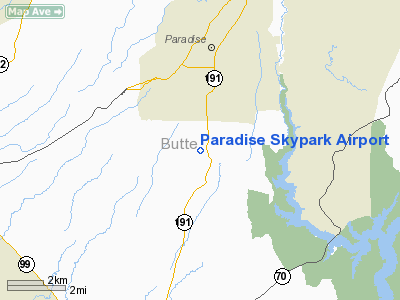
3 nautical miles S of Paradise, CA |
|
Location: |
Butte County, CA |
|
Magnetic Variation: |
17E (1985) |
Owner
& Manager
|
Ownership: |
Privately owned |
|
Owner: |
John H Franklin |
|
Address: |
217 Flume St, Suite 200
Chico, CA 95928 |
|
Phone
number: |
530-343-9600 |
|
Manager: |
Jaime Hutsell |
|
Address: |
217 Flume St., Suite 200
Chico, CA 95928 |
|
Phone number: |
530-343-9600 |
Airport
Operations and Facilities
|
Airport
Use: |
Open to public |
|
Wind
indicator: |
Yes |
|
Segmented
Circle: |
Yes |
|
Control
Tower: |
No |
|
Attendance
Schedule: |
UNATTND |
|
Lighting
Schedule: |
RDO-CTL
ACTVT LIRL RY 17/35 - CTAF. TRIL RY 35 DUSK-DAWN. |
|
Sectional
chart: |
San Francisco |
|
Region: |
AWP - Western-Pacific |
|
Traffic
Pattern Alt: |
800 ft |
|
Boundary
ARTCC: |
ZOA - Oakland |
|
Tie-in
FSS: |
RIU - Rancho Murieta |
|
FSS
on Airport: |
No |
|
FSS
Phone: |
916-354-0161 |
|
FSS
Toll Free: |
1-800-WX-BRIEF |
|
NOTAMs
Facility: |
RIU (NOTAM-d service avaliable) |
|
Federal Agreements: |
N |
Airport
Communications
|
CTAF: |
122.800 |
|
Unicom: |
122.800 |
Airport
Services
|
Fuel
available: |
100LL
FOR FUEL CALL (530) 343-9600 IN ADVANCE. |
|
Airframe
Repair: |
MAJOR |
|
Power
Plant Repair: |
MAJOR |
|
Bottled
Oxygen: |
NONE |
|
Bulk
Oxygen: |
NONE |
|
Runway Information
Runway 17/35
|
Dimension: |
3017 x 60 ft / 919.6 x 18.3 m |
|
Surface: |
ASPH, Good Condition |
|
Edge
Lights: |
Low |
|
|
Runway 17 |
Runway 35 |
|
Longitude: |
121-36-58.9636W |
121-36-59.9246W |
|
Latitude: |
39-42-52.9377N |
39-42-23.1354N |
|
Elevation: |
1347.00 ft |
1283.00 ft |
|
Alignment: |
127 |
1 |
|
Traffic
Pattern: |
Right |
Left |
|
Markings: |
Nonstandard, Good Condition
RWY 17 DSPLCD MARKINGS MISSING SMALL WHITE ARROWS AT THRESHOLD |
Basic, Good Condition |
|
Displaced
threshold: |
427.00 ft |
0.00
ft |
|
VASI: |
|
tri-color on left side |
|
Runway
End Identifier: |
No |
No |
|
Centerline
Lights: |
No |
No |
|
Touchdown
Lights: |
No |
No |
|
Obstruction: |
115 ft tree, 1200.0 ft from runway, 25 ft left
of centerline, 25:1 slope to clear
APCH RATIO 32:1 BASED ON DSPLCD THLD.
/35 TREES 150 FT WEST OF RY CNTRLN AND TREES 150 FT EAST OF
RY CNTRLN. |
, 50:1 slope to clear |
|
Radio Navigation
Aids
|
ID |
Type |
Name |
Ch |
Freq |
Var |
Dist |
|
OVE |
NDB |
Oroville |
|
212.00 |
16E |
13.0 nm |
|
MY |
NDB |
Halow |
|
222.00 |
16E |
32.5 nm |
|
PBT |
NDB |
Proberta |
|
338.00 |
16E |
37.5 nm |
|
BAB |
TACAN |
Beale |
023X |
|
16E |
35.6 nm |
|
CIC |
VOR/DME |
Chico |
035X |
109.80 |
16E |
11.7 nm |
|
MYV |
VOR/DME |
Marysville |
045X |
110.80 |
16E |
36.8 nm |
|
MXW |
VORTAC |
Maxwell |
037X |
110.00 |
18E |
36.7 nm |
|
RBL |
VORTAC |
Red Bluff |
104X |
115.70 |
18E |
36.9 nm |
|
ILA |
VORTAC |
Williams |
091X |
114.40 |
18E |
42.9 nm |
Remarks
- STEEP
DOWNGRADE EAST; WEST; & SOUTH OF RWY.
- LAND
RY 35; TKOF RY17. NIGHT LDG RY 35 3017 FT LGTD. RY 17 NIGHT LDGS NOT
AUTH. DUE TO MOUNTAINOUS TERRAIN WITH TREES APROX. 450-700 YDS FROM
RY END.
- FOR
INFORMATION OR UNOFFICIAL WEATHER REPORTS CALL (530) 343-9600.
- ARPT
SURROUNDED BY +40 FT TREES EAST AND WEST SIDES.
- ARPT
CLOSED TO NIGHT OPNS INDEFLY.
Based Aircraft
|
Aircraft
based on field: |
45 |
|
Single
Engine Airplanes: |
44 |
|
Multi
Engine Airplanes: |
1 |
Operational Statistics
|
Aircraft
Operations: |
287/Week |
|
Air Taxi: |
3.4% |
|
General
Aviation Local: |
64.4% |
|
General
Aviation Itinerant: |
32.2% |
Paradise Skypark Airport
Address:
Butte County, CA
Tel:
530-343-9600
Images
and information placed above are from
http://www.airport-data.com/airport/L24/
We
thank them for the data!
| General
Info |
| Country |
United
States |
| State |
CALIFORNIA
|
| FAA ID |
L24
|
| Latitude |
39.710556
39� 42' 38.00" N |
| Longitude |
-121.616500
121� 36' 59.40" W |
| Elevation |
1300 feet
396 meters |
| Magnetic
Variation |
015� E
(01/06) |
| Operating
Agency |
U.S.CIVIL
AIRPORT WHEREIN PERMIT COVERS USE BY TRANSIT MILITARY AIRCRAFT
|
We don't guarantee the information is fresh and accurate. The data may
be wrong or outdated.
For more up-to-date information please refer to other sources.
|
|


