 |
|
Palo Alto Airport Of Santa Clara Co Airport |
Palo Alto Airport
of Santa Clara County |
 |
| Outdated diagram |
| IATA: PAO – ICAO: KPAO – FAA LID: PAO |
| Summary |
| Airport type |
Public |
| Operator |
County of Santa Clara |
| Location |
Palo Alto, California |
| Elevation AMSL |
4 ft / 1.2 m |
| Coordinates |
37°27′40″N 122°06′54″W / 37.46111°N 122.115°W / 37.46111; -122.115Coordinates: 37°27′40″N 122°06′54″W / 37.46111°N 122.115°W / 37.46111; -122.115 |
| Runways |
| Direction |
Length |
Surface |
| ft |
m |
| 13/31 |
2,443 |
745 |
Asphalt |
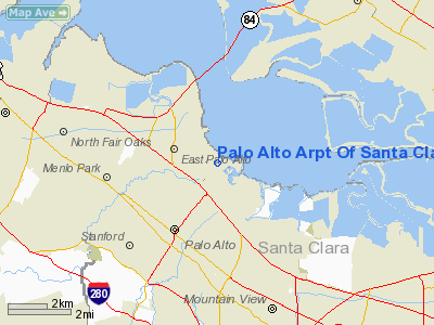
Palo Alto Airport of Santa Clara County (IATA: PAO, ICAO: KPAO, FAA LID: PAO) is a general aviation airport in the city of Palo Alto in Santa Clara County, California, USA, near the south end of San Francisco Bay on the western shore. Facilities
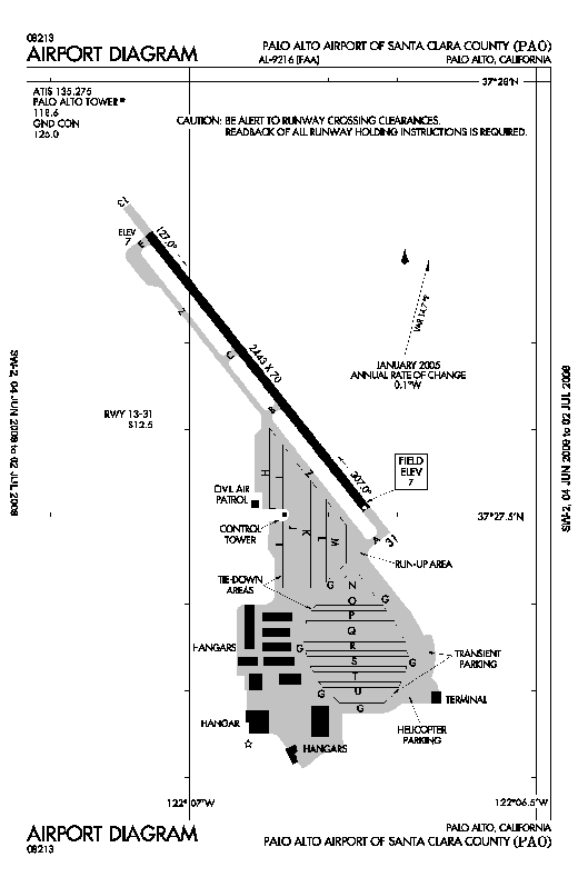
Palo Alto Airport of Santa Clara County covers 102 acres (41 ha) and has one asphalt paved runway (13/31) measuring 2,443 x 70 ft. (745 x 21 m).
First time pilots should familiarize themselves with the complex SF Bay Area airspace, especially the overlying SFO Class B and the abutting SJC Class C airspace. Landing pilots should also watch out for bird and jackrabbit activity.
Facilities at this busy towered airport include multiple aircraft repair shops and a staffed terminal, including a car rental counter. The airport is located within one-half mile of U.S. Route 101.
Fifteen miles of hiking and biking trails, affording multiple opportunities for birdwatching, form part of the adjacent 1,940-acre (785 ha) Palo Alto Baylands Nature Preserve. The airport is also adjacent to a public golf course. Dining options within a short walk include the Abundant Air Cafe, the Bay Cafe at the Golf Course and the popular Ming's Restaurant.
Instrument Approaches
Palo Alto airport has two approaches, both to runway 31 with 460' MDA/ 1-mi visibility minimums:
- GPS Runway 31
- VOR/DME Runway 31 from San Jose VOR
The VOR approach is almost impossible to get from ATC if you are GPS-equipped, because of the conflict with airline traffic in San Jose International.
Area history
In 1989 a comprehensive area history analysis was conducted by Earth Metrics, based upon review of extant aerial photographs.(Earth Metrics, 1989) The photo reconnaissance flights were flown in 1956, 1960, 1973, 1974 and 1980 by the U.S. Department of the Interior, and are archived by the U.S. Geological Survey in Menlo Park, California.
Comparison of the aerial photographs indicate that no development had begun in the vicinity prior to 1956 other than the Palo Alto Airport and the Regional Water Quality Control Board Plant (terminus of Embarcadero Way). Between 1956 and 1960, no new development had taken place in the area; however, by 1973, the Harvey Gum Factory was on the subject site and structures were either completed or under construction at 1890 Embarcadero Road and 2440-2450 Embarcadero Way. Conditions were identical in the 1974 aerial photograph. In the 1980 aerial photograph, the Harvey Gum Factory is standing, and additional infill construction can be seen in the area such as the Baylands Business Park adjacent and to south of the site and the structure now located at 1860 Embarcadero Road. The Harvey Gum Factory was demolished in 1982, based upon Palo Alto Planning Department records.
World War II
The airport was opened to the public in April 1940. Taken over by the United States Army Air Force on 22 March 1941 as a basic (level 1) pilot training airfield. Assigned to USAAF West Coast Training Center (later Western Flying Training Command). Conducted contract basic flying training. Fairchild PT-19s were the primary trainer used. Also had several PT-17 Stearmans and a few P-40 Warhawks assigned. There may have been as many as six auxiliary airfields in the area used for emergency and overflow landings during its USAAF use.
Transferred to the United States Navy as King City NAAS in April 1945. Returned to civil control in December 1945.
The above content comes from Wikipedia and is published under free licenses – click here to read more.
Location
& QuickFacts
|
FAA
Information Effective: |
2006-09-28 |
|
Airport
Identifier: |
PAO |
|
Longitude/Latitude: |
122-06-54.2000W/37-27-40.0000N
-122.115056/37.461111 (Estimated) |
|
Elevation: |
4 ft / 1.22 m (Estimated) |
|
Land: |
102 acres |
|
From
nearest city: |
0 nautical miles E of Palo Alto, CA |
|
Location: |
Santa Clara County, CA |
|
Magnetic Variation: |
15E (1995) |
Owner
& Manager
|
Ownership: |
Publicly owned |
|
Owner: |
Co Of Santa Clara |
|
Address: |
2500 Cunningham Ave
San Jose, CA 95148 |
|
Phone
number: |
408-929-1060
CARL HONAKER, DIRECTOR OF AIRPORTS. |
|
Manager: |
Lawrence J. Feldman |
|
Address: |
1925 Embarcadero Road
Palo Alto, CA 94303 |
|
Phone number: |
650-856-7833 |
Airport
Operations and Facilities
|
Airport
Use: |
Open to public |
|
Wind
indicator: |
Yes |
|
Segmented
Circle: |
Yes |
|
Control
Tower: |
Yes |
|
Attendance
Schedule: |
ALL/ALL/0700-2300 |
|
Lighting
Schedule: |
DUSK-DAWN |
|
Beacon
Color: |
Clear-Green (lighted land airport) |
|
Landing
fee charge: |
No |
|
Sectional
chart: |
San Francisco |
|
Region: |
AWP - Western-Pacific |
|
Boundary
ARTCC: |
ZOA - Oakland |
|
Tie-in
FSS: |
OAK - Oakland |
|
FSS
on Airport: |
No |
|
FSS
Phone: |
510-273-6111 |
|
FSS
Toll Free: |
1-800-WX-BRIEF |
|
NOTAMs
Facility: |
PAO (NOTAM-d service avaliable) |
|
Federal Agreements: |
NGY |
Airport
Communications
|
CTAF: |
118.600 |
|
Unicom: |
122.950 |
Airport
Services
|
Fuel
available: |
100LLA
SELF-FUELING AVAILBLE 24/7. |
|
Airframe
Repair: |
MAJOR |
|
Power
Plant Repair: |
MAJOR |
|
Bottled
Oxygen: |
LOW |
|
Runway Information
Runway 13/31
|
Dimension: |
2443 x 70 ft / 744.6 x 21.3 m |
|
Surface: |
ASPH, Good Condition |
|
Weight
Limit: |
Single wheel: 12500 lbs. |
|
Edge
Lights: |
Medium |
|
|
Runway 13 |
Runway 31 |
|
Longitude: |
122-07-03.5484W |
122-06-44.7693W |
|
Latitude: |
37-27-49.5066N |
37-27-30.5562N |
|
Elevation: |
7.00
ft |
7.00
ft |
|
Alignment: |
127 |
127 |
|
Traffic
Pattern: |
Left |
Right |
|
Markings: |
Basic, Good Condition |
Basic, Good Condition |
|
Crossing
Height: |
29.00 ft |
29.00 ft |
|
VASI: |
4-light PAPI on left side |
4-light PAPI on left side |
|
Visual
Glide Angle: |
4.00� |
4.00� |
|
Runway
End Identifier: |
Yes |
Yes |
|
Centerline
Lights: |
No |
No |
|
Touchdown
Lights: |
No |
No |
|
Obstruction: |
8 ft dike, 280.0 ft from runway, 10:1 slope
to clear |
6 ft berm, 345.0 ft from runway, 80 ft left
of centerline, 24:1 slope to clear
RY 31 +3' DIKE 200' FROM END OF RWY, OBSTN LGTD. |
|
Radio Navigation
Aids
|
ID |
Type |
Name |
Ch |
Freq |
Var |
Dist |
|
LV |
NDB |
Reiga |
|
374.00 |
16E |
24.8 nm |
|
TCY |
NDB |
Tracy |
|
203.00 |
15E |
34.8 nm |
|
PDG |
NDB |
Pajar |
|
327.00 |
17E |
36.0 nm |
|
NUQ |
TACAN |
Moffett |
123X |
|
17E |
3.2 nm |
|
SUU |
TACAN |
Travis |
113X |
|
17E |
47.8 nm |
|
SJC |
VOR/DME |
San Jose |
088X |
114.10 |
16E |
9.7 nm |
|
SFO |
VOR/DME |
San Francisco |
105X |
115.80 |
17E |
15.6 nm |
|
CCR |
VOR/DME |
Concord |
117X |
117.00 |
17E |
35.2 nm |
|
OSI |
VORTAC |
Woodside |
086X |
113.90 |
17E |
8.9 nm |
|
OAK |
VORTAC |
Oakland |
115X |
116.80 |
17E |
16.7 nm |
|
SAU |
VORTAC |
Sausalito |
109X |
116.20 |
17E |
30.6 nm |
|
SGD |
VORTAC |
Scaggs Island |
058X |
112.10 |
17E |
44.9 nm |
|
SFO |
VOT |
San Francisco Intl |
|
111.00 |
|
15.6 nm |
Remarks
- +200'
TRANS TWRS SE OF ARPT.
- LANDING
NOT AUTHORIZED FOR PURE JET AND SURPLUS MILITARY AIRCRAFT EXCEPT THOSE
ACFT MEETING FAR 36 STAGE 3 NOISE CRITERIA.
- BIRDS
ON AND IN VICINITY OF AIRPORT.
- TPA
1000 FT WEST & 800 FT EAST.
- NOISE
SENSITIVE AREA SE THRU W OF ARPT. RCMD ACFT LNDG AT PALO ALTO ARPT FLY
AT OR ABOVE 1500 FT UNTIL CROSSING THE BAYSHORE FREEWAY. RCMD ACFT DEP
RY 31 TURN 10 DEG RIGHT AFTER TKOF UNTIL REACHING DUMBARTON BRIDGE.
- BE
ALERT FOR PEDESTRAINS CROSSING A DIKE ROAD 8 FT HIGH AND 80 FT FROM
APCH END RY 13.
- CONTINUOUS
PEDESTRIAN/VEHICLE ACTIVITY ON ACFT TAXI LANES NOT DESIGNATED AS TWY
MOVEMENT AREAS.
- AIRPORT
SECURITY PROCEDURES IN EFFECT.
- ON
APCH TO RY 31 BE ALERT TO POSSIBLE STRONG UPDRAFT FM WIND TUNNEL LCTD
ON WEST SIDE OF MOFFETT FEDERAL AIRFIELD.
Based Aircraft
|
Aircraft
based on field: |
527 |
|
Single
Engine Airplanes: |
480 |
|
Multi
Engine Airplanes: |
44 |
|
Helicopters: |
2 |
|
Gliders: |
1 |
Operational Statistics
|
Aircraft
Operations: |
584/Day |
|
Air Taxi: |
0.0% |
|
General
Aviation Local: |
59.5% |
|
General
Aviation Itinerant: |
40.5% |
Palo Alto Arpt Of Santa Clara Co Airport
Address:
Santa Clara County, CA
Tel:
408-929-1060, 650-856-7833
Images
and information placed above are from
http://www.airport-data.com/airport/PAO/
We
thank them for the data!
| General
Info |
| Country |
United
States |
| State |
CALIFORNIA
|
| FAA ID |
PAO
|
| Latitude |
37-27-40.000N
|
| Longitude |
122-06-54.200W
|
| Elevation |
4 feet
|
| Near City |
PALO ALTO
|
We don't guarantee the information is fresh and accurate. The data may
be wrong or outdated.
For more up-to-date information please refer to other sources.
|
|


