 |
|
| O'Sullivan Army Heliport |
| IATA: CSL – ICAO: KCSL – FAA LID: CSL |
| Summary |
| Airport type |
Military |
| Owner |
United States Army |
| Location |
Camp San Luis Obispo, California |
| Elevation AMSL |
250 ft / 76 m |
| Coordinates |
35°19′34″N 120°44′35″W / 35.32611°N 120.74306°W / 35.32611; -120.74306 |
| Helipads |
| Number |
Length |
Surface |
| ft |
m |
| H1 |
2,430 |
741 |
Asphalt |
| Source: Federal Aviation Administration |
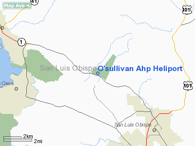
O'Sullivan Army Heliport (IATA: CSL, ICAO: KCSL, FAA LID: CSL) is a U.S. Army heliport at Camp San Luis Obispo in San Luis Obispo County, California, United States. It is located just off California State Route 1, northwest of the city of San Luis Obispo, about halfway between it and Morro Bay. O'Sullivan AHP has one helipad designated H1 with a 2,430 by 75 ft (741 x 23 m) asphalt surface.
The above content comes from Wikipedia and is published under free licenses – click here to read more.
Location
& QuickFacts
|
FAA
Information Effective: |
2006-09-28 |
|
Airport
Identifier: |
CSL |
|
Longitude/Latitude: |
120-44-03.6250W/35-19-59.9070N
-120.734340/35.333308 (Estimated) |
|
Elevation: |
250 ft / 76.20 m (Estimated) |
|
Land: |
0 acres |
|
From
nearest city: |
3 nautical miles N of Camp San Luis Obispo,
CA |
|
Location: |
San Luis Obispo County, CA |
|
Magnetic Variation: |
15E (1985) |
Owner
& Manager
|
Ownership: |
Army owned |
|
Owner: |
Us Army Atca-aso |
|
Address: |
Cameron Station
Alexandria, VA 22314 |
|
Address: |
|
Airport
Operations and Facilities
|
Airport
Use: |
Private |
|
Segmented
Circle: |
No |
|
Control
Tower: |
No |
|
Sectional
chart: |
Los Angeles |
|
Region: |
AWP - Western-Pacific |
|
Boundary
ARTCC: |
ZLA - Los Angeles |
|
Tie-in
FSS: |
HHR - Hawthorne |
|
FSS
on Airport: |
No |
|
FSS
Phone: |
310-970-0102 |
|
FSS
Toll Free: |
1-800-WX-BRIEF |
|
Runway Information
Helipad H1
|
Dimension: |
2430 x 75 ft / 740.7 x 22.9 m |
|
Surface: |
ASPH, |
|
|
Runway H1 |
Runway |
|
Traffic
Pattern: |
Left |
Left |
|
Radio Navigation
Aids
|
ID |
Type |
Name |
Ch |
Freq |
Var |
Dist |
|
HGT |
NDB |
Hunter Liggett |
|
209.00 |
15E |
43.8 nm |
|
VBG |
TACAN |
Vandenberg |
059Y |
|
15E |
36.9 nm |
|
GLJ |
VOR |
Guadalupe |
|
111.00 |
16E |
25.2 nm |
|
ROM |
VOR |
Priest |
|
110.00 |
16E |
48.6 nm |
|
MQO |
VORTAC |
Morro Bay |
071X |
112.40 |
16E |
5.0 nm |
|
PRB |
VORTAC |
Paso Robles |
090X |
114.30 |
16E |
21.1 nm |
|
AVE |
VORTAC |
Avenal |
118X |
117.10 |
16E |
41.5 nm |
|
FLW |
VORTAC |
Fellows |
122X |
117.50 |
16E |
45.0 nm |
Remarks
- WHITE
X'S ON RY H1; RY CLSD TO F/W ACFT.
O'sullivan Ahp Heliport
Address:
San Luis Obispo County, CA
Tel:
Images
and information placed above are from
http://www.airport-data.com/airport/CSL/
We
thank them for the data!
| General
Info |
| Country |
United
States |
| State |
CALIFORNIA
|
| FAA ID |
CSL
|
| Latitude |
35-19-59.907N
|
| Longitude |
120-44-03.625W
|
| Elevation |
250 feet
|
| Near City |
CAMP SAN
LUIS OBISPO |
We don't guarantee the information is fresh and accurate. The data may
be wrong or outdated.
For more up-to-date information please refer to other sources.
|
|


