|
|
Oroville Municipal Airport |
| Oroville Municipal Airport |
 |
| IATA: OVE – ICAO: KOVE |
| Summary |
| Airport type |
Public |
| Operator |
City of Oroville |
| Location |
Oroville, California |
| Elevation AMSL |
192 ft / 58.5 m |
| Coordinates |
39°29′16.20″N 121°37′19.20″W / 39.487833°N 121.622°W / 39.487833; -121.622Coordinates: 39°29′16.20″N 121°37′19.20″W / 39.487833°N 121.622°W / 39.487833; -121.622 |
| Runways |
| Direction |
Length |
Surface |
| ft |
m |
| 1/19 |
6,020 |
1,835 |
Asphalt |
| 12/30 |
3,540 |
1,079 |
Asphalt |
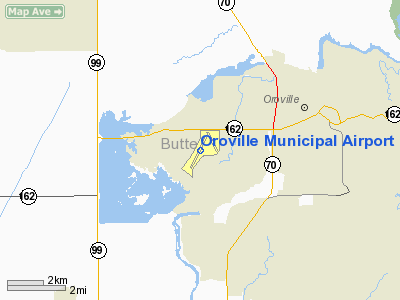
Oroville Municipal Airport (IATA: OVE, ICAO: KOVE) is a public airport located 3 miles (5 km) southwest of the city of Oroville in Butte County, California, USA. Facilities
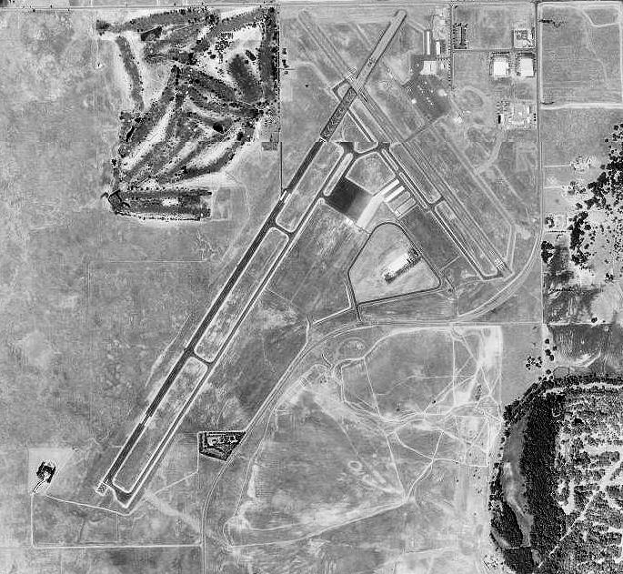
Oroville Municipal Airport covers 920 acres (3.7 km) and has two runways:
- Runway 1/19: 6,020 x 100 ft (1,835 x 30 m), Surface: Asphalt
- Runway 12/30: 3,540 x 100 ft (1,079 x 30 m), Surface: Asphalt
Table Mountain Aviation is part of the Oroville Municipal Airport, which lies approximately 3 miles (4.8 km) southwest of downtown.
The airport has two runways: Runway 1-19 (6,020 feet long and 100 feet wide) and Runway 12-30 (3,540 feet long and 100 feet wide). The runway system is anchored by three major parallel taxiways:
- Taxiway A is a full-length 60-foot-wide taxiway (18 m) located on the east side of Runway 1-19
- Taxiway J is a full-length 40-foot-wide taxiway (12 m) located on the west side of Runway 12-30
- Taxiway R is a full-length 70-foot-wide taxiway (21 m) located on the east side of Runway 12-30
Three main apron areas exist on the airfield. The largest apron area is located around the Table Mountain Aviation FBO buildings. The FBO apron area is home to 38 tie-downs as well as the fuel tanks and provides access to Taxiway R to the west of the apron and Taxiway S to the north of the apron. The second largest apron area is located in the midfield area of the airfield, south of Runway 19. This apron area is home to 76 tie downs. The third apron area is located east of the Table Mountain Golf Course and provides space for 5 tie downs, and is ideal for golfers that fly to the Airport. For more information, visit the website: http://www.tablemountainaviation.com/
History
In 1936, the City of Oroville acquired 188 acres (0.76 km) of grazing land for use as a municipal airport. During 1941, the city and the Works Project Administration (WPA) extended the runways and increased the total airport land area to 428 acres (1.73 km).
In 1942, the War Department leased the Oroville Municipal Airport and renamed it Oroville Army Air Field (AAF). That same year the Army purchased an additional 381.98 acres (1.5458 km) of land for expansion of the field and construction of a cantonement area. Once operational, it served as a fighter group training installation from spring of 1943 through early summer 1944. Two fighter groups rotated through Oroville AAF: the 357th Fighter Group (fighter group of famed pilots Chuck Yeager and Bud Anderson) and the 369th Fighter Group. Aircraft present at the field were identified as the Bell P-39Q Airacobra, North American P-51B/C/D Mustangs, and possibly the North American A-36 Apache, the ground attack version of the P-51.
Layout plans of the former Oroville AAF dated 1944 indicate a Bomb Storage Area west of the two runways and a skeet range between the southern extents of the runways. Fueling pit boxes were located along former Taxiways A (running parallel to runway 12/30) and C (connecting the southernmost ends of runways 1/19 and 12/30). A 1947 Inventory Report of Buildings and Structures states that bombs were stored in earth revetments.
In 1945 Oroville AAF was listed as “temporarily inactive” under assignment to Air Technical Service Command and was later classified as surplus. In 1946 the War Assets Administration (WAA) assumed custody of the site and on 21 May 1947, the WAA terminated the U.S. Army’s lease with the City of Oroville and returned ownership to civil authorities.
The above content comes from Wikipedia and is published under free licenses – click here to read more.
Location
& QuickFacts
|
FAA
Information Effective: |
2006-09-28 |
|
Airport
Identifier: |
OVE |
|
Longitude/Latitude: |
121-37-19.2000W/39-29-16.2000N
-121.622000/39.487833 (Estimated) |
|
Elevation: |
192 ft / 58.52 m (Surveyed) |
|
Land: |
920 acres |
|
From
nearest city: |
3 nautical miles SW of Oroville, CA |
|
Location: |
Butte County, CA |
|
Magnetic Variation: |
16E (1990) |
Owner
& Manager
|
Ownership: |
Publicly owned |
|
Owner: |
City Of Oroville |
|
Address: |
1735 Montgomery St
Oroville, CA 95965 |
|
Phone number: |
530-538-2420 |
|
Manager: |
Ruben Duran |
|
Address: |
1735 Montgomery St.
Oroville, CA 95965 |
|
Phone number: |
530-538-2420 |
Airport
Operations and Facilities
|
Airport
Use: |
Open to public |
|
Wind
indicator: |
Yes |
|
Segmented
Circle: |
Yes |
|
Control
Tower: |
No |
|
Attendance
Schedule: |
UNATNDD |
|
Lighting
Schedule: |
DUSK-DAWN
ACTVT HIRL RY 01/19 & RY 12/30 - CTAF, PAPI RY 19, VASI
RY 12 & RY 30 OPER CONT. |
|
Beacon
Color: |
Clear-Green (lighted land airport) |
|
Landing
fee charge: |
No |
|
Sectional
chart: |
San Francisco |
|
Region: |
AWP - Western-Pacific |
|
Traffic
Pattern Alt: |
800 ft |
|
Boundary
ARTCC: |
ZOA - Oakland |
|
Tie-in
FSS: |
RIU - Rancho Murieta |
|
FSS
on Airport: |
No |
|
FSS
Phone: |
916-354-0161 |
|
FSS
Toll Free: |
1-800-WX-BRIEF |
|
NOTAMs
Facility: |
OVE (NOTAM-d service avaliable) |
|
Federal Agreements: |
NGPRY |
Airport
Communications
|
CTAF: |
122.800 |
|
Unicom: |
122.800 |
Airport
Services
|
Fuel
available: |
100LLA |
|
Airframe
Repair: |
NONE |
|
Power
Plant Repair: |
NONE |
|
Bottled
Oxygen: |
NONE |
|
Bulk
Oxygen: |
NONE |
|
Runway Information
Runway 01/19
|
Dimension: |
6020 x 100 ft / 1834.9 x 30.5 m |
|
Surface: |
ASPH, Good Condition |
|
Weight
Limit: |
Single wheel: 60000 lbs.
Dual wheel: 80000 lbs. |
|
Edge
Lights: |
High |
|
|
Runway 01 |
Runway 19 |
|
Longitude: |
121-37-54.5048W |
121-37-12.7149W |
|
Latitude: |
39-28-43.8522N |
39-29-33.7637N |
|
Elevation: |
181.00 ft |
185.00 ft |
|
Alignment: |
33 |
127 |
|
Traffic
Pattern: |
Left |
Left |
|
Markings: |
Basic, Fair Condition |
Basic, Fair Condition |
|
Crossing
Height: |
0.00
ft |
41.00 ft |
|
VASI: |
|
2-light PAPI on left side |
|
Visual
Glide Angle: |
0.00� |
3.00� |
|
Runway
End Identifier: |
No |
No |
|
Centerline
Lights: |
No |
No |
|
Touchdown
Lights: |
No |
No |
|
Runway 12/30
|
Dimension: |
3540 x 100 ft / 1079.0 x 30.5 m |
|
Surface: |
ASPH, Good Condition |
|
Weight
Limit: |
Single wheel: 25000 lbs. |
|
Edge
Lights: |
High |
|
|
Runway 12 |
Runway 30 |
|
Longitude: |
121-37-07.8997W |
121-36-41.2117W |
|
Latitude: |
39-29-42.7344N |
39-29-14.5126N |
|
Elevation: |
193.00 ft |
177.00 ft |
|
Alignment: |
127 |
127 |
|
Traffic
Pattern: |
Left |
Left |
|
Markings: |
Basic, Good Condition |
Basic, Good Condition |
|
Crossing
Height: |
32.00 ft |
32.00 ft |
|
VASI: |
2-box on left side |
2-box on left side |
|
Visual
Glide Angle: |
3.00� |
3.00� |
|
Runway
End Identifier: |
No |
No |
|
Centerline
Lights: |
No |
No |
|
Touchdown
Lights: |
No |
No |
|
Obstruction: |
, 50:1 slope to clear |
20 ft trees, 600.0 ft from runway, 200 ft left
of centerline, 20:1 slope to clear |
|
Helipad H1
|
Dimension: |
25
x 25 ft / 7.6 x 7.6 m |
|
Surface: |
ASPH, Good Condition |
|
|
Runway H1 |
Runway |
|
Traffic
Pattern: |
Left |
Left |
|
Helipad H2
|
Dimension: |
25
x 25 ft / 7.6 x 7.6 m |
|
Surface: |
ASPH, Good Condition |
|
|
Runway H2 |
Runway |
|
Traffic
Pattern: |
Left |
Left |
|
Radio Navigation
Aids
|
ID |
Type |
Name |
Ch |
Freq |
Var |
Dist |
|
OVE |
NDB |
Oroville |
|
212.00 |
16E |
0.4 nm |
|
MY |
NDB |
Halow |
|
222.00 |
16E |
19.1 nm |
|
PBT |
NDB |
Proberta |
|
338.00 |
16E |
47.2 nm |
|
BAB |
TACAN |
Beale |
023X |
|
16E |
22.8 nm |
|
CIC |
VOR/DME |
Chico |
035X |
109.80 |
16E |
20.9 nm |
|
MYV |
VOR/DME |
Marysville |
045X |
110.80 |
16E |
23.5 nm |
|
MXW |
VORTAC |
Maxwell |
037X |
110.00 |
18E |
29.7 nm |
|
ILA |
VORTAC |
Williams |
091X |
114.40 |
18E |
31.3 nm |
|
RBL |
VORTAC |
Red Bluff |
104X |
115.70 |
18E |
46.4 nm |
|
SMF |
VOT |
Sacramento Metropolitan |
|
111.40 |
|
47.9 nm |
Remarks
- TWY
FM RY 1/19 TO GOLF COURSE/RESTAURANT TIEDOWNS 20 FT WIDE WITH NO SHOULDERS.
- FIREFIGHTING
ACFT INVOF ARPT MAY-OCT.
- FOR
ARPT INFO MON-FRI CTC (530)538-2490.
Based Aircraft
|
Aircraft
based on field: |
32 |
|
Single
Engine Airplanes: |
25 |
|
Multi
Engine Airplanes: |
2 |
|
Helicopters: |
1 |
|
Ultralights: |
4 |
Operational Statistics
|
Aircraft
Operations: |
99/Day |
|
Air Taxi: |
4.2% |
|
General
Aviation Local: |
40.3% |
|
General
Aviation Itinerant: |
55.6% |
Oroville Municipal Airport
Address:
Butte County, CA
Tel:
530-538-2420
Images
and information placed above are from
http://www.airport-data.com/airport/OVE/
We
thank them for the data!
| General
Info |
| Country |
United
States |
| State |
CALIFORNIA
|
| FAA ID |
OVE
|
| Latitude |
39-29-15.900N
|
| Longitude |
121-37-19.200W
|
| Elevation |
192 feet
|
| Near City |
OROVILLE
|
We don't guarantee the information is fresh and accurate. The data may
be wrong or outdated.
For more up-to-date information please refer to other sources.
|
|