|
|
Nevada County Air Park Airport |
Nevada County Air Park
Nevada County Airport |
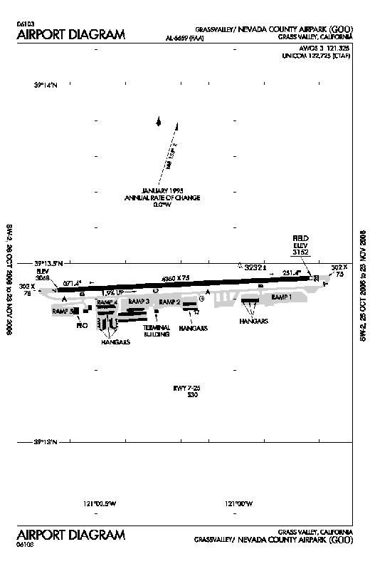 |
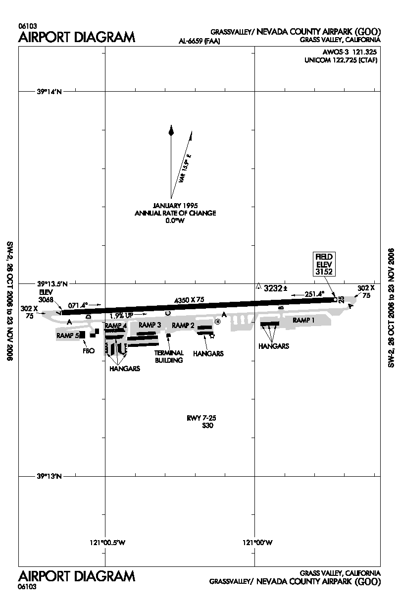
| FAA airport diagram |
| IATA: none – ICAO: KGOO – FAA LID: GOO |
| Summary |
| Airport type |
Public |
| Owner |
Nevada County |
| Location |
Grass Valley, California |
| Elevation AMSL |
3,152 ft / 961 m |
| Coordinates |
39°13′26″N 121°00′11″W / 39.22389°N 121.00306°W / 39.22389; -121.00306 |
| Website |
mynevadacounty.com/... |
| Runways |
| Direction |
Length |
Surface |
| ft |
m |
| 7/25 |
4,350 |
1,326 |
Asphalt |
| Statistics (2001) |
| Aircraft operations |
27,750 |
| Based aircraft |
142 |
| Source: FAA and airport website |
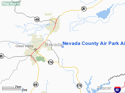
Nevada County Air Park (ICAO: KGOO, FAA LID: GOO, formerly O17) is a county-owned public use airport in Nevada County, California, United States. The airport is located three nautical miles (6 km) east of the central business district of Grass Valley, California. It is also known as Nevada County Airport.
Although most U.S. airports use the same three-letter location identifier for the FAA and IATA, this airport is assigned GOO by the FAA but has no designation from the IATA (which assigned GOO to an airport in Goondiwindi, Queensland, Australia).
Facilities and aircraft
Nevada County Air Park covers an area of 117 acres (47 ha) at an elevation of 3,152 feet (961 m) above mean sea level. It has one asphalt paved runway designated 7/25 which measures 4,350 by 75 feet (1,326 x 23 m).
For the 12-month period ending December 31, 2001, the airport had 27,750 aircraft operations, an average of 76 per day: 96% general aviation and 4% air taxi. At that time there were 142 aircraft based at this airport: 95% single-engine, 4% multi-engine and 1% helicopter.
The above content comes from Wikipedia and is published under free licenses – click here to read more.
Location
& QuickFacts
|
FAA
Information Effective: |
2006-09-28 |
|
Airport
Identifier: |
GOO |
|
Longitude/Latitude: |
121-00-11.1000W/39-13-26.5000N
-121.003083/39.224028 (Estimated) |
|
Elevation: |
3152 ft / 960.73 m (Surveyed) |
|
Land: |
117 acres |
|
From
nearest city: |
3 nautical miles E of Grass Valley, CA |
|
Location: |
Nevada County, CA |
|
Magnetic Variation: |
16E (2000) |
Owner
& Manager
|
Ownership: |
Publicly owned |
|
Owner: |
Nevada County |
|
Address: |
P.o. Box 6100
Nevada City, CA 95959-6100 |
|
Phone
number: |
530-477-0103 |
|
Manager: |
Greg Marshall
GREGORY.MARSHALL@CO.NEVADA.CA.US |
|
Address: |
950 Maidu Avenue
Nevada City, CA 95959-8617 |
|
Phone number: |
530-273-3374 |
Airport
Operations and Facilities
|
Airport
Use: |
Open to public |
|
Wind
indicator: |
Yes |
|
Segmented
Circle: |
Yes |
|
Control
Tower: |
No |
|
Attendance
Schedule: |
ALL/ALL/0800-1700 |
|
Lighting
Schedule: |
DUSK-DAWN
ACTVT MIRL RY 07/25 - CTAF. |
|
Beacon
Color: |
Clear-Green (lighted land airport) |
|
Landing
fee charge: |
No |
|
Sectional
chart: |
San Francisco |
|
Region: |
AWP - Western-Pacific |
|
Traffic
Pattern Alt: |
1000 ft |
|
Boundary
ARTCC: |
ZOA - Oakland |
|
Tie-in
FSS: |
RIU - Rancho Murieta |
|
FSS
on Airport: |
No |
|
FSS
Phone: |
916-354-0161 |
|
FSS
Toll Free: |
1-800-WX-BRIEF |
|
NOTAMs
Facility: |
RIU (NOTAM-d service avaliable) |
|
Federal Agreements: |
NGY |
Airport
Communications
|
CTAF: |
122.725 |
|
Unicom: |
122.725 |
Airport
Services
|
Fuel
available: |
100LLA |
|
Airframe
Repair: |
MAJOR |
|
Power
Plant Repair: |
MAJOR |
|
Bottled
Oxygen: |
NONE |
|
Runway Information
Runway 07/25
|
Dimension: |
4350
x 75 ft / 1325.9 x 22.9 m
RY 07 STOPWAY 302 FT X 75 FT ASPHALT. RY
25 STOPWAY 302 FT X 75 FT ASPHALT. |
|
Surface: |
ASPH, Good Condition |
|
Weight
Limit: |
Single wheel: 30000 lbs. |
|
Edge
Lights: |
Medium
MIRL RY 07/25, VASI RYS 07 AND 25 OTS INDEFLY. |
|
|
Runway 07 |
Runway 25 |
|
Longitude: |
121-00-38.7200W |
120-59-43.5100W |
|
Latitude: |
39-13-25.5100N |
39-13-27.5500N |
|
Elevation: |
3068.00 ft |
3152.00 ft |
|
Alignment: |
87 |
127 |
|
Traffic
Pattern: |
Left |
Left |
|
Markings: |
Basic, Good Condition |
Basic, Good Condition |
|
Crossing
Height: |
40.00 ft |
37.00 ft |
|
VASI: |
4-box on left side
VASI OTS INDEFLY. |
2-box on left side |
|
Visual
Glide Angle: |
3.00� |
3.50� |
|
Runway
End Identifier: |
Yes |
Yes |
|
Centerline
Lights: |
No |
No |
|
Touchdown
Lights: |
No |
No |
|
Obstruction: |
20 ft trees, 612.0 ft from runway, 190 ft left
of centerline, 20:1 slope to clear |
100 ft pole, 2600.0 ft from runway, 235 ft
right of centerline, 24:1 slope to clear |
|
Radio Navigation
Aids
|
ID |
Type |
Name |
Ch |
Freq |
Var |
Dist |
|
MY |
NDB |
Halow |
|
222.00 |
16E |
28.5 nm |
|
OVE |
NDB |
Oroville |
|
212.00 |
16E |
33.1 nm |
|
BAB |
TACAN |
Beale |
023X |
|
16E |
21.1 nm |
|
MYV |
VOR/DME |
Marysville |
045X |
110.80 |
16E |
27.6 nm |
|
HNW |
VOR/DME |
Hangtown |
102X |
115.50 |
17E |
32.3 nm |
|
SWR |
VOR/DME |
Squaw Valley |
079X |
113.20 |
16E |
34.3 nm |
|
MCC |
VOR/DME |
Mc Clellan |
029X |
109.20 |
17E |
38.4 nm |
|
ILA |
VORTAC |
Williams |
091X |
114.40 |
18E |
48.6 nm |
|
SMF |
VOT |
Sacramento Metropolitan |
|
111.40 |
|
42.2 nm |
|
SAC |
VOT |
Sacramento Executive |
|
111.40 |
|
48.6 nm |
Remarks
- EAST
ACFT TIEDOWN APRON 12500 LBS MAXIMUM.
- <
TANKERS AIR FOR>
- RWY
07/25 SLOPES DOWNHILL TO WEST; RECOMMEND TKOF RWY 25.
- RY
07 CLSD TKOF AT NIGHT AND RY 25 CLSD LNDG AT NIGHT.
- DUE
TO RY GRADIENT WIDTH & CROSSWINDS USE OF RY 07/25 NOT RECOMMENDED
FOR STUDENT SOLO CROSS-COUNTRY FLIGHTS.
- EXISTED
PRIOR TO 1959.
Based Aircraft
|
Aircraft
based on field: |
128 |
|
Single
Engine Airplanes: |
116 |
|
Multi
Engine Airplanes: |
12 |
Operational Statistics
|
Aircraft
Operations: |
77/Day |
|
Air Taxi: |
3.6% |
|
General
Aviation Local: |
53.2% |
|
General
Aviation Itinerant: |
43.2% |
Nevada County Air Park Airport
Address:
Nevada County, CA
Tel:
530-477-0103,
530-273-3374
Images
and information placed above are from
http://www.airport-data.com/airport/GOO/
We
thank them for the data!
| General
Info |
| Country |
United
States |
| State |
CALIFORNIA
|
| FAA ID |
GOO
|
| Time |
UTC-8(-7DT)
|
| Latitude |
39.224028
39� 13' 26.50" N |
| Longitude |
-121.003083
121� 00' 11.10" W |
| Elevation |
3152 feet
961 meters |
| Type |
Civil
|
| Magnetic
Variation |
015� E
(01/06) |
| Beacon |
Yes
|
| Operating
Agency |
U.S.CIVIL
AIRPORT WHEREIN PERMIT COVERS USE BY TRANSIT MILITARY AIRCRAFT
|
| Near City |
Grass
Valley |
| Operating
Hours |
SEE REMARKS
FOR OPERATING HOURS OR COMMUNICATIONS FOR POSSIBLE HOURS |
| Daylight
Savings Time |
First
Sunday in April at 0200 to last Sunday in October at 0200 local time
(Exception Arizona and that portion of Indiana in the Eastern Time
Zone) |
We don't guarantee the information is fresh and accurate. The data may
be wrong or outdated.
For more up-to-date information please refer to other sources.
|
|