|
|
| Needles Airport |
 |
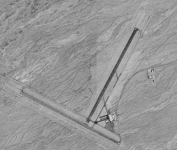
| USGS aerial image, 21 May 1994 |
| IATA: EED – ICAO: KEED – FAA LID: EED |
| Summary |
| Airport type |
Public |
| Owner |
County of San Bernardino |
| Serves |
Needles, California |
| Elevation AMSL |
983 ft / 300 m |
| Coordinates |
34°45′59″N 114°37′24″W / 34.76639°N 114.62333°W / 34.76639; -114.62333 |
| Website |
www.sbcounty.gov/... |
| Runways |
| Direction |
Length |
Surface |
| ft |
m |
| 2/20 |
4,235 |
1,291 |
Asphalt |
| 11/29 |
5,005 |
1,526 |
Asphalt |
| Statistics (2006) |
| Aircraft operations |
10,500 |
| Based aircraft |
8 |
| Source: Federal Aviation Administration |
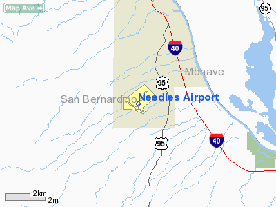
Needles Airport (IATA: EED, ICAO: KEED, FAA LID: EED) is a county-owned, public-use airport in San Bernardino County, California, United States. It is located five nautical miles (9 km) south of the central business district of Needles. According to the FAA's National Plan of Integrated Airport Systems for 2009–2013, it is categorized as a general aviation airport.
The airfield was opened in May 1941. During World War II the airfield was known as Needles Army Airfield and was used by the United States Army Air Forces Fourth Air Force. With the end of the war, the base was declared excess to requirements and returned to civil control. Facilities and aircraft
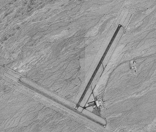
Needles Airport covers an area of 796 acres (322 ha) at an elevation of 983 feet (300 m) above mean sea level. It has two asphalt paved runways: 2/20 is 4,235 by 100 feet (1,291 x 30 m) and 11/29 is 5,005 by 100 feet.
For the 12-month period ending February 17, 2006, the airport had 10,500 general aviation aircraft operations, an average of 28 per day. At that time there were 8 aircraft based at this airport: 62.5% single-engine and 37.5% ultralight.
The above content comes from Wikipedia and is published under free licenses – click here to read more.
Location
& QuickFacts
|
FAA
Information Effective: |
2006-09-28 |
|
Airport
Identifier: |
EED |
|
Longitude/Latitude: |
114-37-23.8076W/34-45-58.8486N
-114.623280/34.766347 (Estimated) |
|
Elevation: |
983 ft / 299.62 m (Surveyed) |
|
Land: |
796 acres |
|
From
nearest city: |
5 nautical miles S of Needles, CA |
|
Location: |
San Bernardino County, CA |
|
Magnetic Variation: |
13E (1985) |
Owner
& Manager
|
Ownership: |
Publicly owned |
|
Owner: |
Co Of San Bernardino |
|
Address: |
825 E 3rd St, Room 203
San Bernardino, CA 92415 |
|
Phone
number: |
909-387-7801 |
|
Manager: |
Terry Stover
AIRPORTS DIRECTOR, BILL INGRAHAM - (909) 387-7806 OR 7801.
GLENN
SIMS - LEASE THE AIRPORT FROM COUNTY (760) 326-5263. |
|
Address: |
21600 Corwin Road
Apple Valley, CA 92307 |
|
Phone number: |
760-247-2371 |
Airport
Operations and Facilities
|
Airport
Use: |
Open to public |
|
Wind
indicator: |
Yes |
|
Segmented
Circle: |
Yes |
|
Control
Tower: |
No |
|
Attendance
Schedule: |
ALL/ALL/0800-1700
ARPT ATTENDED BY PARADICE AVIATION 760-326-5263. |
|
Lighting
Schedule: |
DUSK-DAWN
ACTVT MIRL RY 11/29 & RY 02/20, REIL RY 11& RY 29
- CTAF. PAPI
RY 11 & RY 29 OPER CONTINUOUSLY. |
|
Beacon
Color: |
Clear-Green (lighted land airport) |
|
Landing
fee charge: |
No |
|
Sectional
chart: |
Phoenix |
|
Region: |
AWP - Western-Pacific |
|
Traffic
Pattern Alt: |
1000 ft |
|
Boundary
ARTCC: |
ZLA - Los Angeles |
|
Tie-in
FSS: |
RAL - Riverside |
|
FSS
on Airport: |
No |
|
FSS
Phone: |
951-351-3020 |
|
FSS
Toll Free: |
1-800-WX-BRIEF |
|
NOTAMs
Facility: |
EED (NOTAM-d service avaliable) |
|
Federal Agreements: |
NGSY3 |
Airport
Communications
|
CTAF: |
123.000 |
|
Unicom: |
123.000 |
Airport
Services
|
Fuel
available: |
100LLA |
|
Airframe
Repair: |
MINOR |
|
Power
Plant Repair: |
MINOR |
|
Bottled
Oxygen: |
NONE |
|
Bulk
Oxygen: |
NONE |
|
Runway Information
Runway 02/20
|
Dimension: |
4235 x 100 ft / 1290.8 x 30.5 m |
|
Surface: |
ASPH, Fair Condition |
|
Weight
Limit: |
Single wheel: 16000 lbs.
Dual wheel: 32000 lbs. |
|
Edge
Lights: |
Medium |
|
|
Runway 02 |
Runway 20 |
|
Longitude: |
114-37-23.0500W |
114-36-58.3250W |
|
Latitude: |
34-45-51.7500N |
34-46-28.3440N |
|
Elevation: |
929.00 ft |
844.00 ft |
|
Alignment: |
29 |
127 |
|
Traffic
Pattern: |
Left |
Left |
|
Markings: |
Basic, Good Condition |
Basic, Good Condition |
|
Runway 11/29
|
Dimension: |
5005 x 100 ft / 1525.5 x 30.5 m |
|
Surface: |
ASPH, Good Condition |
|
Weight
Limit: |
Single wheel: 16000 lbs.
Dual wheel: 32000 lbs. |
|
Edge
Lights: |
Medium |
|
|
Runway 11 |
Runway 29 |
|
Longitude: |
114-38-01.1140W |
114-37-08.7050W |
|
Latitude: |
34-46-01.4100N |
34-45-37.3360N |
|
Elevation: |
983.00 ft |
918.00 ft |
|
Alignment: |
119 |
127 |
|
Traffic
Pattern: |
Left |
Left |
|
Markings: |
Basic, Good Condition |
Basic, Good Condition |
|
Crossing
Height: |
40.00 ft |
40.00 ft |
|
VASI: |
2-light PAPI on left side |
2-light PAPI on left side |
|
Visual
Glide Angle: |
3.00� |
3.00� |
|
Runway
End Identifier: |
Yes |
Yes |
|
Radio Navigation
Aids
|
ID |
Type |
Name |
Ch |
Freq |
Var |
Dist |
|
IGM |
VOR/DME |
Kingman |
025X |
108.80 |
15E |
45.1 nm |
|
EED |
VORTAC |
Needles |
099X |
115.20 |
15E |
7.4 nm |
|
GFS |
VORTAC |
Goffs |
091X |
114.40 |
15E |
35.0 nm |
|
PKE |
VORTAC |
Parker |
126X |
117.90 |
15E |
40.0 nm |
Remarks
-
< 3200?
APRX ARPT OF SOUTH & WEST MTN>
- ESTABD
PRIOR TO 5/15/59.
Based Aircraft
|
Aircraft
based on field: |
24 |
|
Single
Engine Airplanes: |
21 |
|
Ultralights: |
3 |
Operational Statistics
|
Aircraft
Operations: |
202/Week |
|
General
Aviation Local: |
23.8% |
|
General
Aviation Itinerant: |
76.2% |
Needles Airport
Address:
San Bernardino County, CA
Tel:
909-387-7801,
760-247-2371
Images
and information placed above are from
http://www.airport-data.com/airport/EED/
We
thank them for the data!
| General
Info |
| Country |
United
States |
| State |
CALIFORNIA
|
| FAA ID |
EED
|
| Latitude |
34-45-58.300N
|
| Longitude |
114-37-23.855W
|
| Elevation |
983 feet
|
| Near City |
NEEDLES
|
We don't guarantee the information is fresh and accurate. The data may
be wrong or outdated.
For more up-to-date information please refer to other sources.
|
|