|
|
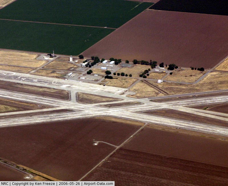
Nasa Crows Landing Airport |
|
 |
(Click on the photo to enlarge) |
|
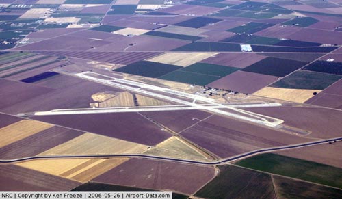 |
(Click on the photo to enlarge) |
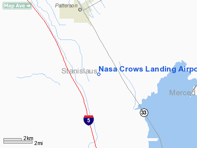
Location
& QuickFacts
|
FAA
Information Effective: |
2006-09-28 |
|
Airport
Identifier: |
NRC |
|
Longitude/Latitude: |
121-06-33.7540W/37-24-28.7660N
-121.109376/37.407991 (Estimated) |
|
Elevation: |
166 ft / 50.60 m (Estimated) |
|
Land: |
0 acres |
|
From
nearest city: |
1 nautical miles NE of Crows Landing, CA |
|
Location: |
Stanislaus County, CA |
|
Magnetic Variation: |
16E (1985) |
Owner
& Manager
|
Ownership: |
Publicly owned |
|
Owner: |
Nasa Ames Research Ctr |
|
Address: |
Airfield Mgt Ofs M/s 158-01
Moffett Field, CA 94035-1000 |
|
Phone
number: |
415-604-0685 |
|
Manager: |
Gary Tiffany
ASST MGR JOHN GORDON (415) 604-0931. |
|
Address: |
Airfield Mgt Ofs M/s 158-01
Moffett Field, CA 94035-1000 |
|
Phone number: |
415-604-0685 |
Airport
Operations and Facilities
|
Airport
Use: |
Private |
|
Segmented
Circle: |
No |
|
Control
Tower: |
No |
|
Attendance
Schedule: |
UNATNDD |
|
Lighting
Schedule: |
DUSK-DAWN
HIRL RYS 12/30 & 17/35 & BCN INOP WHEN ARPT UNATNDD. |
|
Beacon
Color: |
Clear-Green (lighted land airport) |
|
Sectional
chart: |
San Francisco |
|
Region: |
AWP - Western-Pacific |
|
Boundary
ARTCC: |
ZOA - Oakland |
|
Tie-in
FSS: |
RIU - Rancho Murieta |
|
FSS
on Airport: |
No |
|
FSS
Phone: |
916-354-0161 |
|
FSS
Toll Free: |
1-800-WX-BRIEF |
|
NOTAMs
Facility: |
RIU (NOTAM-d service avaliable) |
|
Runway Information
Runway 12/30
|
Dimension: |
6975 x 200 ft / 2126.0 x 61.0 m |
|
Surface: |
CONC, |
|
Edge
Lights: |
High |
|
|
Runway 12 |
Runway 30 |
|
Traffic
Pattern: |
Left |
Left |
|
Arresting: |
E5 E28 |
|
|
Runway 17/35
|
Dimension: |
7950 x 200 ft / 2423.2 x 61.0 m |
|
Surface: |
CONC, |
|
Weight
Limit: |
Single wheel: 59000 lbs.
Dual wheel: 99000 lbs.
Dual
tandem wheel: 215000 lbs. |
|
Edge
Lights: |
High |
|
|
Runway 17 |
Runway 35 |
|
Traffic
Pattern: |
Left |
Left |
|
Arresting: |
E5 E28 |
E5 E28 |
|
Radio Navigation
Aids
|
ID |
Type |
Name |
Ch |
Freq |
Var |
Dist |
|
TCY |
NDB |
Tracy |
|
203.00 |
15E |
23.4 nm |
|
LV |
NDB |
Reiga |
|
374.00 |
16E |
32.3 nm |
|
PDG |
NDB |
Pajar |
|
327.00 |
17E |
44.8 nm |
|
NUQ |
TACAN |
Moffett |
123X |
|
17E |
45.3 nm |
|
MOD |
VOR/DME |
Modesto |
093X |
114.60 |
17E |
15.0 nm |
|
HYP |
VOR/DME |
El Nido |
089X |
114.20 |
15E |
35.7 nm |
|
SJC |
VOR/DME |
San Jose |
088X |
114.10 |
16E |
39.9 nm |
|
ECA |
VORTAC |
Manteca |
107X |
116.00 |
17E |
25.8 nm |
|
LIN |
VORTAC |
Linden |
095X |
114.80 |
17E |
40.4 nm |
|
PXN |
VORTAC |
Panoche |
073X |
112.60 |
16E |
44.5 nm |
Remarks
- CAUTION:
MANY LGT ACFT TRANSITING AREA. FQT CROP DUSTER ACFT IN VCNTY OF ARPT
BELOW 500' AGL. LIGHT TO HEAVY BIRD ACTVTY ON AND IN VCNTY OF ARPT.
- (ARPT
STATUS) ARPT CLSD PERMLY.
Nasa Crows Landing Airport
Address:
Stanislaus County, CA
Tel:
415-604-0685
Images
and information placed above are from
http://www.airport-data.com/airport/NRC/
We
thank them for the data!
| General
Info |
| Country |
United
States |
| State |
CALIFORNIA
|
| FAA ID |
NRC
|
| Latitude |
37-24-28.766N
|
| Longitude |
121-06-33.754W
|
| Elevation |
166 feet
|
| Near City |
CROWS
LANDING |
We don't guarantee the information is fresh and accurate. The data may
be wrong or outdated.
For more up-to-date information please refer to other sources.
|
|