|
|
| Mojave Air and Space Port |
 |
| in 2009 |
| IATA: MHV – ICAO: KMHV |
| Summary |
| Airport type |
Public |
| Operator |
Kern County |
| Serves |
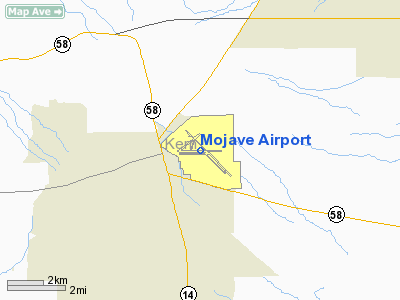
Mojave, California |
| Elevation AMSL |
2,791 ft / 851 m |
| Coordinates |
35°03′34″N 118°09′06″W / 35.05944°N 118.15167°W / 35.05944; -118.15167 |
| Runways |
| Direction |
Length |
Surface |
| ft |
m |
| 12/30 |
12,503 |
3,811 |
Asphalt/Concrete |
| 08/26 |
7,050 |
2,149 |
Asphalt |
| 04/22 |
4,743 |
1,446 |
Asphalt |
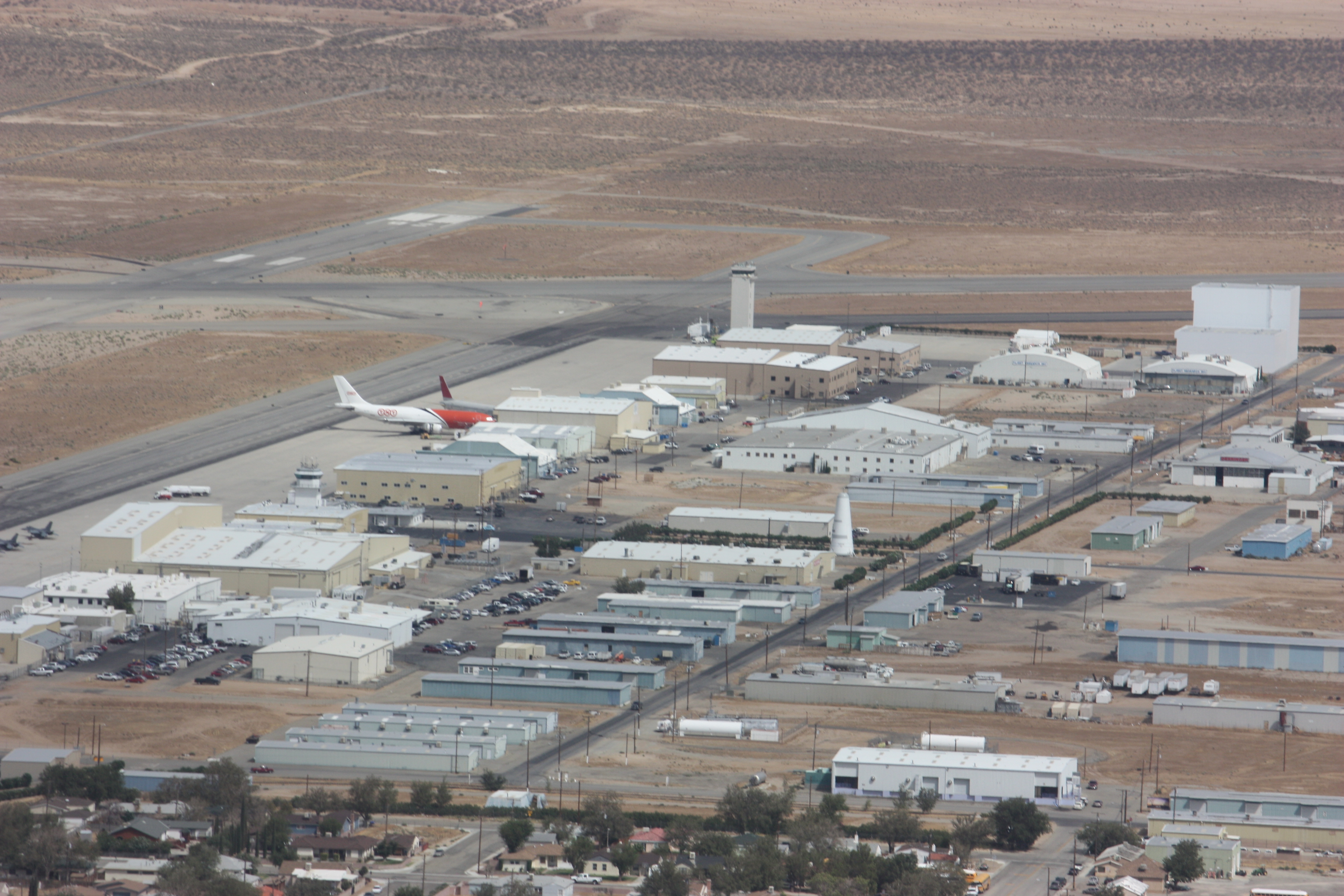
Mojave spaceport 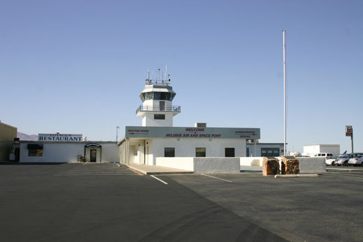 | |
Administration offices, restaurant and old tower |
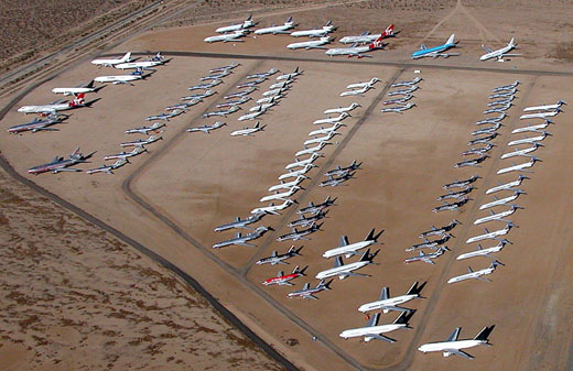 | |
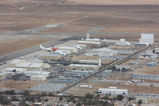
Mojave Airport, storage location for commercial airliners. |
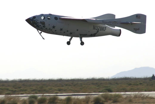 | |
SpaceShipOne landing at Mojave after June 21, 2004 space flight |
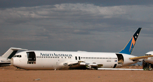 | |
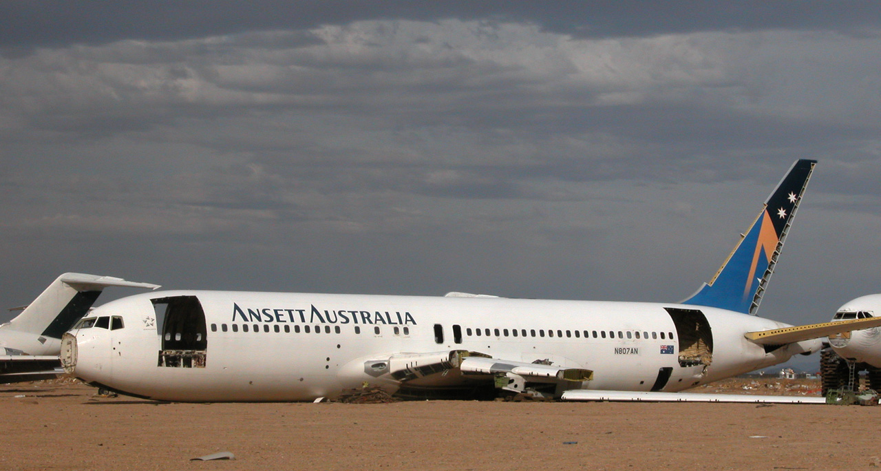
A retired Boeing 767-200 that flew for Ansett Australia being cut open for scrap at Mojave Airport |
The Mojave Air and Space Port (IATA: MHV, ICAO: KMHV), also known as the Civilian Aerospace Test Center, is located in Mojave, California, at an elevation of 2,791 feet (851 m). It is the first facility to be licensed in the United States for horizontal launches of reusable spacecraft, being certified as a spaceport by the Federal Aviation Administration on June 17, 2004. Activities
Besides being a general-use public airport, Mojave has three main areas of activity: flight testing, space industry development, and aircraft heavy maintenance and storage.
Air Racing
The airport has a rich history in Air Racing. In 1970, a 1000-mile Unlimited race was held--the first closed-course pylon race to include pit stops. The race was notable in that it featured a DC-7 airliner, which flew non-stop and finished sixth out of twenty aircraft. The race was won by Sherm Cooper in a highly modified Hawker Sea Fury which also flew non-stop. The following year the race was shortened to 1000-km, and was again won by a Hawker Sea Fury, this time flown by Frank Sanders. From 1973-1979, Air Race Management (run by famed race pilots Clay Lacy and Lyle Shelton) organized a series of Reno-syle races at Mojave featuring Unlimiteds, T-6's, Formula-1's, and Bipanes. In 1973 and '74, the program also included jet races. Unlimited winners at Mojave included Lyle Shelton in 1973, Mac McClain in 1974 and 1976, Dr. Cliff Cummins in 1975, and Steve Hinton in 1978 and '79. The races at Mojave were hampered by constant winds, and extreme temperatures. In the 2000's, California HWY 58 was extended to bypass the town of Mojave, which cut directly across the race course--thus precluding any future racing events on the site. In 1983, Frank Taylor set the 15km closed-course speed record at 517 mph at Mojave in the P-51 Dago Red. Over the years, several notable teams have been based out of Mojave. The two active race teams currently based at Mojave are Nemesis Air Racing (Sharp Nemesis NXT), and Wasabi Air Racing. In 1990 Scaled Composites rolled out the radical Pond Racer--built and tested on-site. During the mid-90's, the Museum of Flying based its two racers Dago Red and Stiletto out of Mojave as well. And since the early '80's, the oft-talked about, but rarely seen Wildfire (a custom built Unlimited based around a T-6 airframe) has slowly been developed in a Mojave hanger. The GT 400 Quicksilver ultralight program is also based out of Mojave airport.
Flight testing
Flight testing activities have been centered at Mojave since the early 1970s, due to the lack of populated areas surrounding the airport. It is also favored for this purpose due to its proximity to the Edwards Air Force Base, where the airspace is restricted from ground level to an unlimited height, and where there is a supersonic corridor. Mojave is also the home of the National Test Pilot School and Scaled Composites
Space industry development
Beginning with the Rotary Rocket program, Mojave became a focus for small companies seeking a place to develop space access technologies. Mojave Spaceport has been a test site for several teams in the Ansari X Prize, most notably SpaceShipOne, which conducted the first privately funded human sub-orbital flight on June 21, 2004. Other groups based at the Mojave Spaceport include XCOR Aerospace, Masten Space Systems, Orbital Sciences Corporation, and Interorbital Systems.
The East Kern Airport District has been given spaceport status by the Federal Aviation Administration for the Mojave Air and Spaceport through June 16, 2014.
Aircraft heavy maintenance and storage
The Mojave airport is also known as a storage location for commercial airliners, due to the vast area and dry desert conditions. Numerous large Boeing, McDonnell Douglas, Lockheed, and Airbus aircraft owned by major airlines are stored at Mojave. Some aircraft reach the end of their useful lifetime and are scrapped at the Mojave aircraft boneyard, while others are refurbished and returned to active service.
History
The Mojave Airport was first opened in 1935 as a small, rural airfield serving the local gold and silver mining industry.
In July 1942, the U.S. Marine Corps took over the field and vastly expanded it as the Marine Corps Auxiliary Air Station (MCAAS) Mojave. Many of the Corps' World War II aces received their gunnery training at Mojave. With the end of World War II, MCAAS was disestablished in 1946, and became instead a U.S. Navy airfield. At the end of 1953, the USMC reopened MCAAS Mojave as an auxiliary field to MCAS El Toro.
In 1961, after the USMC transferred operations to MCAS El Centro, Kern County obtained title to the airport. In February 1972, the East Kern Airport District was formed to administer the airport; EKAD maintains the airport to this day. To a great extent EKAD was the brainchild of Dan Sabovich who heavily lobbied the state for the airport district's creation and ran EKAD until 2002.
First flights and significant events
- July 1, 1942 – Construction begins on Marine Corps Auxiliary Air Station at Mojave.
- July 31, 1944 – USMC Capt. Edward Shaw, a decorated World War II ace, was killed while test-flying an F4U Corsair
- February 7, 1946 – MCAAS disestablished.
- December 31, 1953 – MCAAS Mojave re-established.
- May 21, 1975 – First flight of the Rutan VariEze
- June 30, 1978 – First flight of the Rutan Defiant
- June 12, 1979 – First flight of the prototype of the Rutan Long-EZ
- April 3, 1980 – First prototype Bombardier Challenger 600 crashed in the Mojave desert, killing one of the pilots; flight test program was operating from Mojave at the time.
- September 25, 1981 – National Test Pilot School opens
- August 23, 1983 – First flight of the Boeing Skyfox
- August 29, 1983 - First flight of Beech/Scaled Composites Model 115 Starship
- January 7, 1986 – Voyager homecoming, after round-the-world record flight.
- July 12, 1988 – First flight of the Scaled Composites Triumph
- February 19, 1990 – First flight of the Scaled Composites ARES
- July 26, 1998 – First flight of the Scaled Composites Proteus
- March 1, 1999 – Rollout of the Rotary Rocket Roton ATV.
- July 28, 1999 - First flight of the Roton ATV.
- October 12, 1999 - third, final and longest flight of Roton ATV.
- October 8, 2000 – First firing of an XCOR Aerospace LOX-powered rocket engine.
- July 21, 2001 – First flight of the XCOR EZ-Rocket, flown by Dick Rutan (single-engine configuration).
- October 6, 2001 - First flight of a twin engine rocket plane, again the XCOR EZ-rocket.
- May 31, 2002 – First flight of the Toyota TAA-1, built by Scaled Composites.
- July 24, 2002 - First touch-and-go of a rocket powered aircraft, the XCOR EZ-Rocket (world record).
- August 1, 2002 - First flight of Scaled Composites White Knight
- September 18, 2002 - First flight of world's largest jet engine, GE90-115B on GE's Boeing 747 testbed aircraft.
- May 20, 2003 – First captive flight, unmanned, of SpaceShipOne
- July 29, 2003 - First manned captive flight of SpaceShipOne
- August 7, 2003 - First free-flight of SpaceShipOne
- December 17, 2003 - First powered flight of SpaceShipOne, on 100th anniversary of powered flight by the Wright Brothers.
- March 5, 2004 – First flight of the Virgin Atlantic GlobalFlyer
- June 17, 2004 - Mojave designated a Spaceport by the FAA.
- June 21, 2004 - SpaceShipOne flight 15P, the first spaceflight of SpaceShipOne.
- September 29, 2004 - First Ansari X Prize flight of SpaceShipOne.
- October 4, 2004 - X-Prize-winning flight of SpaceShipOne.
- June 21, 2005 – First captive flight of Boeing X-37 under Scaled Composites White Knight
- December 3, 2005 - First departure of a rocket-powered aircraft on a point-to-point flight (XCOR EZ-Rocket, departed MHV for California City, flown by Dick Rutan).
- December 15, 2005 - First arrival of a rocket-powered aircraft on a flight originating at another airport (XCOR EZ-Rocket return flight from California City, piloted by Rick Searfoss).
- April 7, 2006 – First free flight of Boeing X-37 (take-off from Mojave, landing at Edwards)
- January 23, 2007 – First flight of the Lockheed CATBird
- July 26, 2007 – Explosion with at least three fatalities at Scaled Composites facility.
- January, 2008 - Arrival of Gimli Glider for retirement.
- December 21, 2008 - First flight of Scaled Composites WhiteKnightTwo
- October 7, 2009 - Lunar Lander Challenge flight by Masten Space Systems wins second place for Level 1 of the NASA competition
- October 30, 2009 - Lunar Lander Challenge flight by Masten Space Systems wins first place for Level 2 of the NASA competition
- January 16, 2010 AOPA president Craig Fuller came to speak at MHV.
- May 26, 2010 Masten Space Systems completes the first ever flight of vertical take-off vertical landing (VTVL) vehicle with successfully re-light the rocket engine.
Civilian Aerospace Test Center test programs
- Boeing X-37
- Eclipse 500 (crosswind landing data)
- General Electric CF34
- General Electric GE90
- Lockheed CATBird (post modification and systems flight test)
- Lockheed Martin F-22 Raptor (crosswind landing data)
- Lockheed Martin VH-71 Kestrel
- McDonnell Douglas MD-90-30
- Air Tractor 401 modified with an Orenda Aerospace OE600 engine (certification flight test program}
- Rotary Rocket
- Scaled Composites White Knight and SpaceShipOne
- Sino Swearingen SJ30-2 (envelope expansion, flutter, stability and control, crosswind takeoffs and landings)
- Virgin Atlantic GlobalFlyer
- Adaptive Compliant Wing developed by FlexSys Inc flight tested on White Knight.
World records set
- FAI Class C-1, unlimited weight
- Group 1, internal combustion engine
- Speed over a straight 15/25 km course: P-51 Mustang N5410V piloted by Frank Taylor, 832.12 km/h, July 30, 1983.
- Group 3, turbojet
- Speed over Recognised Course: Mojave to Gander, Newfoundland, Canadair Challenger CL601 N601TG piloted by Aziz Ojjeh, 816.48 km/h July 24, 1984.
- Group 4, rocket engine
- Altitude Gain, Airplane Launched from a Carrier Aircraft: 85,743 meters, SpaceShipOne piloted by Mike Melvill, June 21, 2004.
- Distance: 16 km, XCOR EZRocket piloted by Dick Rutan, December 3, 2005
- FAI Class C-1a, Landplanes: take off weight 300 to 500 kg
- Group 1, internal combustion engine
- Distance, Rutan VariEze piloted by Frank Hertzler, Mojave to Martinsburg, West Virginia, 3,563.02 km, July 15, 1984.
- Speed over 3 km course with restricted altitude: DR90 Nemesis piloted by Jon Sharp, 466.83 km/h, November 15, 1998 (aircraft now on display at the National Air & Space Museum)
- Speed over straight 15/25 km course: DR90 Nemesis piloted by Jon Sharp, 454.77 km/h, October 31, 1998.
- FAI Class C-1b, Landplanes: take off weight 500 to 1000 kg
- Group 1, internal combustion engine
- Distance over a closed course: Rutan Long-EZ N79RA piloted by Dick Rutan, 7,725.3 km, December 15, 1979.
- Speed over a closed circuit of 2,000 km without payload. Rutan Catbird N187RA piloted by Dick Rutan, 401.46 km/h, January 29, 1994.
- Group 4, Rocket engine
- Distance: 16 km, XCOR EZRocket piloted by Dick Rutan, December 3, 2005
- FAI Class C-1c, Landplanes: take off weight 1000 to 1750 kg
- Group 1, internal combustion engine
- Speed over a closed circuit of 2,000 km without payload. Rutan Catbird N187RA piloted by Mike Melvill, 413.78 km/h, March 2, 1994.
- FAI Class C-1d, Landplanes: take off weight 1750 to 3000 kg
- Group 1, internal combustion engine
- Distance over a closed course, Voyager N269VA, piloted by Dick Rutan and Jeana Yeager, Vandenburg, California to Mojave, 18,658.16 km, July 15, 1986.
- Group 4, rocket engine
- Altitude Gain, Airplane Launched from a Carrier Aircraft: 85,743 meters, SpaceShipOne piloted by Mike Melvill, June 21, 2004.
- FAI Class C-1e, Landplanes: take off weight 3,000 to 6,000 kg
- Group 2, turbojet
- Altitude: Scaled Composites Proteus N281PR, piloted by Mike Melvill and Robert Waldmiller, 19,277 m, October 25, 2000.
- Altitude in horizontal flight: Scaled Composites Proteus N281PR, piloted by Mike Melvill and Robert Waldmiller, 19,015 m, October 25, 2000.
- Altitude with 1,000 kg payload: Scaled Composites Proteus N281PR, piloted by Mike Melvill and Robert Waldmiller, 17,067 m, October 27, 2000.
Notable pilots and engineersAccidents and incidents
On February 4, 2010, Douglas DC-3-65/AR N834TP of the National Test Pilot School was substantially damaged in a take-off accident. Both sets of undercarriage and the port engine were ripped off. The aircraft was on a local training flight. The accident was caused by an incorrectly-set rudder trim.
Movie/television location credits
Due to the Mojave Spaceport's unique location and facilities, a number of movies, TV shows and commercials have been filmed on location here. The Airport Administration actively promotes the facility as a set. The airport has facilities dedicated for filming, a large supply of aircraft to use as props and two large film pads that can be flooded for water scenes. Action movies and car commercials make up the bulk of the filming at the airport.
Movie credits include: TV credits include: Other credits:
- The Automatic - Steve McQueen music video.
- Berlin - "Take My Breath Away" music video from the soundtrack of Top Gun.
- Dr. Dre - "Keep Their Heads Ringin'" music video from the soundtrack of Friday.
- Robbie Williams- "Bodies" music video
- Verdant Meadows airfield, one of the key locations in video-game Grand Theft Auto: San Andreas is loosely based on Mojave Air and Space Port
The above content comes from Wikipedia and is published under free licenses – click here to read more.
Location
& QuickFacts
|
FAA
Information Effective: |
2006-09-28 |
|
Airport
Identifier: |
MHV |
|
Longitude/Latitude: |
118-09-06.6820W/35-03-33.7130N
-118.151856/35.059365 (Estimated) |
|
Elevation: |
2791 ft / 850.70 m (Surveyed) |
|
Land: |
2998 acres |
|
From
nearest city: |
1 nautical miles E of Mojave, CA |
|
Location: |
Kern County, CA |
|
Magnetic Variation: |
14E (2000) |
Owner
& Manager
|
Ownership: |
Publicly owned |
|
Owner: |
East Kern Airport District |
|
Address: |
1434 Flightline
Mojave, CA 93501 |
|
Phone number: |
661-824-2433 |
|
Manager: |
Stu Witt |
|
Address: |
1434 Flightline
Mojave, CA 93501 |
|
Phone number: |
661-824-2433 |
Airport
Operations and Facilities
|
Airport
Use: |
Open to public |
|
Wind
indicator: |
Yes |
|
Segmented
Circle: |
Yes |
|
Control
Tower: |
Yes |
|
Attendance
Schedule: |
ALL/ALL/ALL |
|
Lighting
Schedule: |
DUSK-DAWN
ACTVT MIRL RY 08/26 & HIRL RY 12/30 - CTAF. |
|
Beacon
Color: |
Clear-Green (lighted land airport) |
|
Landing
fee charge: |
No |
|
Sectional
chart: |
Los Angeles |
|
Region: |
AWP - Western-Pacific |
|
Traffic
Pattern Alt: |
1000 ft |
|
Boundary
ARTCC: |
ZLA - Los Angeles |
|
Tie-in
FSS: |
RAL - Riverside |
|
FSS
on Airport: |
No |
|
FSS
Phone: |
951-351-3020 |
|
FSS
Toll Free: |
1-800-WX-BRIEF |
|
NOTAMs
Facility: |
MHV (NOTAM-d service avaliable) |
|
Federal Agreements: |
NGPY3 |
Airport
Communications
Airport
Services
|
Fuel
available: |
100LLA
FUEL AVBL 0730-DUSK; OTHER TIMES CTC SECURITY ON CTAF.
FEE
CHARGED. |
|
Airframe
Repair: |
MAJOR |
|
Power
Plant Repair: |
MAJOR |
|
Bottled
Oxygen: |
NONE |
|
Bulk
Oxygen: |
NONE |
|
Runway Information
Runway 04/22
|
Dimension: |
4743
x 50 ft / 1445.7 x 15.2 m
300 FT PAVED OVERRUN EAST END OF RY; 300 FT PAVED OVERRUN WEST END
OF RY. |
|
Surface: |
ASPH, Poor Condition
CRACKING, LOOSE GRAVEL AND UNEVEN SECTIONS
FIRST 800' RWY 12 & FIRST 1000' RWY 30 ARE CONC. |
|
Weight
Limit: |
Single wheel: 40000 lbs.
Dual wheel: 60000 lbs.
Dual
tandem wheel: 60000 lbs. |
|
|
Runway 04 |
Runway 22 |
|
Longitude: |
118-09-52.0700W |
118-09-07.2400W |
|
Latitude: |
35-03-34.6500N |
35-04-03.6600N |
|
Elevation: |
2776.00 ft |
2779.00 ft |
|
Alignment: |
52 |
127 |
|
Traffic
Pattern: |
Left |
Right |
|
Markings: |
Basic, Fair Condition |
Basic, Poor Condition
RY NUMBERS EXTEND BEYOND THE EDGES OF THE RY. |
|
Displaced
threshold: |
0.00
ft |
800.00 ft |
|
Runway
End Identifier: |
No |
No |
|
Centerline
Lights: |
No |
No |
|
Touchdown
Lights: |
No |
No |
|
Obstruction: |
44 ft pole, 2200.0 ft from runway, 45:1 slope
to clear |
, 50:1 slope to clear |
|
Runway 08/26
|
Dimension: |
7050
x 100 ft / 2148.8 x 30.5 m
300 FT PAVED OVERRUN EAST END OF RY; 300 FT PAVED OVERRUN WEST END
OF RY. |
|
Surface: |
ASPH, Good Condition
CRACKING, LOOSE GRAVEL AND UNEVEN SECTIONS
FIRST 800' RWY 12 & FIRST 1000' RWY 30 ARE CONC. |
|
Weight
Limit: |
Single wheel: 40000 lbs.
Dual wheel: 60000 lbs.
Dual
tandem wheel: 88000 lbs. |
|
Edge
Lights: |
Medium |
|
|
Runway 08 |
Runway 26 |
|
Longitude: |
118-09-57.9900W |
118-08-33.1900W |
|
Latitude: |
35-03-33.1600N |
35-03-33.0100N |
|
Elevation: |
2777.00 ft |
2732.00 ft |
|
Alignment: |
90 |
127 |
|
Traffic
Pattern: |
Left |
Right |
|
Markings: |
Non-precision instrument, Good Condition |
Non-precision instrument, Good Condition |
|
Crossing
Height: |
0.00
ft |
50.00 ft |
|
VASI: |
|
2-light PAPI on left side |
|
Visual
Glide Angle: |
0.00� |
3.00� |
|
Runway
End Identifier: |
No |
No |
|
Centerline
Lights: |
No |
No |
|
Touchdown
Lights: |
No |
No |
|
Runway 12/30
|
Dimension: |
9502
x 200 ft / 2896.2 x 61.0 m
300 FT PAVED OVERRUN EAST END OF RY; 300 FT PAVED OVERRUN WEST END
OF RY. |
|
Surface: |
ASPH-CONC, Fair Condition
CRACKING, LOOSE GRAVEL AND UNEVEN SECTIONS
FIRST 800' RWY 12 & FIRST 1000' RWY 30 ARE CONC. |
|
Weight
Limit: |
Single wheel: 120000 lbs.
Dual wheel: 150000 lbs.
Dual
tandem wheel: 450000 lbs. |
|
Edge
Lights: |
High |
|
|
Runway 12 |
Runway 30 |
|
Longitude: |
118-09-29.2800W |
118-08-08.6600W |
|
Latitude: |
35-04-02.1000N |
35-02-55.4700N |
|
Elevation: |
2791.00 ft |
2693.00 ft |
|
Alignment: |
127 |
127 |
|
Traffic
Pattern: |
Left |
Right |
|
Markings: |
Basic, Fair Condition |
Basic, Fair Condition |
|
Runway
End Identifier: |
No |
No |
|
Centerline
Lights: |
No |
No |
|
Touchdown
Lights: |
No |
No |
|
Radio Navigation
Aids
|
ID |
Type |
Name |
Ch |
Freq |
Var |
Dist |
|
GWF |
NDB |
Gen William J Fox |
|
282.00 |
15E |
19.5 nm |
|
PAI |
NDB |
Pacoima |
|
370.00 |
15E |
49.8 nm |
|
NID |
TACAN |
China Lake |
053X |
|
16E |
44.0 nm |
|
VCV |
VOR/DME |
Victorville |
031X |
109.40 |
14E |
46.9 nm |
|
EDW |
VORTAC |
Edwards |
111X |
116.40 |
15E |
21.2 nm |
|
PMD |
VORTAC |
Palmdale |
092X |
114.50 |
15E |
26.1 nm |
|
LHS |
VORTAC |
Lake Hughes |
021X |
108.40 |
15E |
30.8 nm |
|
GMN |
VORTAC |
Gorman |
108X |
116.10 |
16E |
38.2 nm |
|
BFL |
VOT |
Bakersfield |
|
111.20 |
|
49.1 nm |
Remarks
- UNLGTD
DIST MARKERS RY 08/26 & 12/30.
- BE
ALERT TO HIGH SPEED ACTIVITY INVOF ARPT.
- TWY
B CLSD INDEFLY.
- TWY
A SOUTH OF TWY B CLSD INDEFLY.
Based Aircraft
|
Aircraft
based on field: |
290 |
|
Single
Engine Airplanes: |
80 |
|
Multi
Engine Airplanes: |
130 |
|
Jet Engine
Airplanes: |
70 |
|
Helicopters: |
3 |
|
Military: |
6 |
|
Ultralights: |
1 |
Operational Statistics
|
Aircraft
Operations: |
49/Day |
|
Air Carrier: |
1.0% |
|
Air Taxi: |
1.0% |
|
General
Aviation Local: |
37.8% |
|
General
Aviation Itinerant: |
58.4% |
|
Military: |
0.8% |
Mojave Airport
Address:
Kern County, CA
Tel:
661-824-2433
Images
and information placed above are from
http://www.airport-data.com/airport/MHV/
We
thank them for the data!
| General
Info |
| Country |
United
States |
| State |
CALIFORNIA
|
| FAA ID |
MHV
|
| Latitude |
35-03-33.713N
|
| Longitude |
118-09-06.682W
|
| Elevation |
2791 feet
|
| Near City |
MOJAVE
|
We don't guarantee the information is fresh and accurate. The data may
be wrong or outdated.
For more up-to-date information please refer to other sources.
|
|