|
|
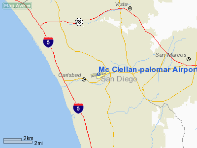
Mc Clellan-palomar Airport |
| McClellan-Palomar Airport |
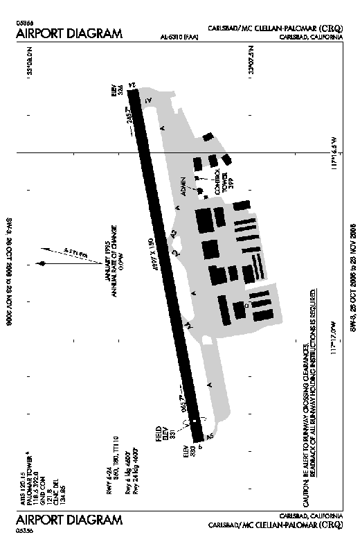 |
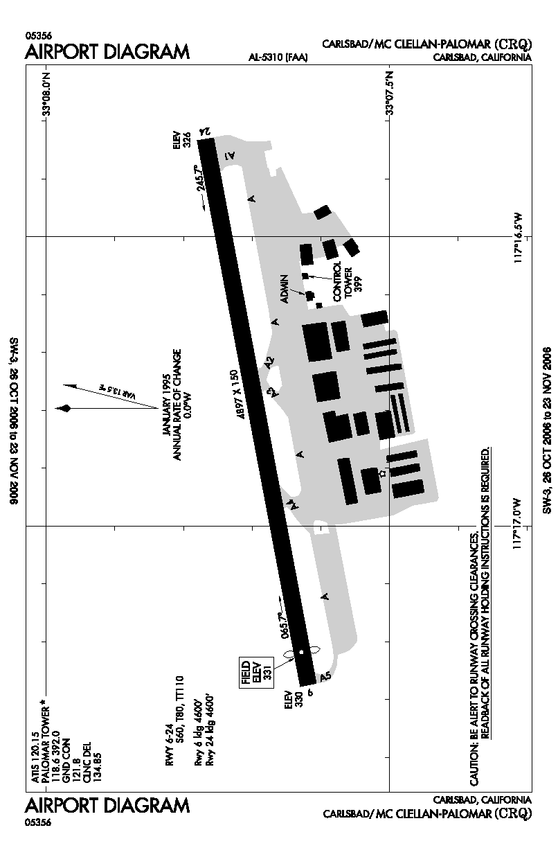
| FAA airport diagram |
| IATA: CLD – ICAO: KCRQ – FAA LID: CRQ |
| Summary |
| Airport type |
Public |
| Owner |
County of San Diego |
| Serves |
Oceanside/Carlsbad, California |
| Elevation AMSL |
331 ft / 101 m |
| Coordinates |
33°07′42″N 117°16′48″W / 33.12833°N 117.28°W / 33.12833; -117.28 (McClellan-Palomar Airport)Coordinates: 33°07′42″N 117°16′48″W / 33.12833°N 117.28°W / 33.12833; -117.28 (McClellan-Palomar Airport) |
| Website |
www.sdcounty.ca.gov/.../palomar.html |
| Runways |
| Direction |
Length |
Surface |
| ft |
m |
| 6/24 |
4,897 |
1,493 |
Asphalt |
| Statistics (2006) |
| Aircraft operations |
202,236 |
| Based aircraft |
354 |
| Sources: FAA, airport website |
McClellan-Palomar Airport (IATA: CLD, ICAO: KCRQ, FAA LID: CRQ) is a public airport located three miles (5 km) southeast of the central business district of Carlsbad, a city in San Diego County, California, United States. It is owned by the County of San Diego and serves the northern part of the county. The airport is mostly used for general aviation, and as of September 2009 United Express is the only commercial airline with regularly scheduled service to Los Angeles International Airport (LAX) from Carlsbad McClellan-Palomar Airport. Previously American Eagle served McClellan-Palomar Airport to LAX, and US Airways Express had service to Phoenix Sky Harbor International Airport (PHX), but those routes have been discontinued. It has basic amenities, including internet access, and has received major upgrades to the terminal over the past several years.
Although most U.S. airports use the same three-letter location identifier for the FAA and IATA, McClellan-Palomar Airport is assigned CRQ by the FAA and CLD by the IATA (which assigned CRQ to Caravelas, Brazil). The airport's ICAO identifier is KCRQ.
The airport is named for Gerald McClellan, an aviator and civic leader in San Diego's North County area. Facilities and aircraft
McClellan-Palomar Airport covers an area of 466 acres (189 ha) which contains one asphalt paved runway (6/24) measuring 4,897 × 150 ft (1,493 × 46 m).
For the 12-month period ending December 31, 2008, the airport had 192,960 aircraft operations, an average of 529 per day: 89% general aviation, 7% air taxi, 3% scheduled commercial and 1% military. There are 325 aircraft based at this airport: 61% single-engine, 24% jet, 11% multi-engine and 4% helicopter.
It opened a new $24 million airline terminal on January 29, 2009. As of November 2009, parking costs $3 per day, with a maximum stay of 30 days.
Airlines and destinations
| Airlines |
Destinations |
| United Express operated by SkyWest Airlines |
Los Angeles |
The airport is planned to be the main hub for California Pacific Airlines, which intends to begin flights on six routes from the airport in late 2010 or early 2011. The planned destinations are Sacramento, California, San Jose, California, Oakland, California, Las Vegas, Nevada, Phoenix, Arizona, and Cabo San Lucas.
Accidents and incidents
- On January 24, 2006, a Cessna Citation V departed runway 24 on landing upon completion of its flight from Friedman Memorial Airport in Hailey, Idaho and burst into flames after crashing into a self-storage facility adjacent to the airport. All four people on board (two passengers and two crew) were killed; no one on the ground was hurt.
- On April 29, 2007, a Cessna 182 Skylane carrying three people crashed approximately 1-mile (1.6 km) off the shore shortly after takeoff at 9:30 am.
- On July 3, 2007, a Beechcraft 90 King Air carrying two people crashed after taking off shortly after 6 am in dense fog. The aircraft hit power lines, which caused power outages for local residents and businesses. The two people onboard the aircraft were confirmed dead.
- On April 19, 2008, a Cessna Citation Mustang skidded off the end of runway 24 and collapsed the main landing gear. The aircraft had four passengers on board, who were uninjured. The Mustang had flown from Lincoln Regional Airport, northeast of Sacramento, California.
- On September 22, 2008, a Cessna 152 crashed just west of College Boulevard on the extended centerline after departing runway 24. The aircraft had two passengers on board, who were both injured and subsequently evacuated by air.
- On September 28, 2008, a Beechcraft Bonanza crashed southeast of the airport after the pilot aborted a landing attempt under foggy conditions. The pilot was the only person on board and was killed.
The above content comes from Wikipedia and is published under free licenses – click here to read more.
|
 |
(Click on the photo to enlarge) |
Location
& QuickFacts
|
FAA
Information Effective: |
2006-09-28 |
|
Airport
Identifier: |
CRQ |
|
Longitude/Latitude: |
117-16-48.3000W/33-07-41.7000N
-117.280083/33.128250 (Estimated) |
|
Elevation: |
331 ft / 100.89 m (Surveyed) |
|
Land: |
466 acres |
|
From
nearest city: |
3 nautical miles SE of Carlsbad, CA |
|
Location: |
San Diego County, CA |
|
Magnetic Variation: |
14E (1980) |
Owner
& Manager
|
Ownership: |
Publicly owned |
|
Owner: |
County Of San Diego |
|
Address: |
1960 Joe Crosson Drive
El Cajon, CA 92020-1235 |
|
Phone
number: |
619-956-4800 |
|
Manager: |
Willie Vasquez |
|
Address: |
2198 Palomar Airport Road
Carlsbad, CA 92011 |
|
Phone number: |
760-431-4646 |
Airport
Operations and Facilities
|
Airport
Use: |
Open to public |
|
Wind
indicator: |
No |
|
Segmented
Circle: |
Yes |
|
Control
Tower: |
Yes |
|
Attendance
Schedule: |
ALL/ALL/0700-2200 |
|
Lighting
Schedule: |
DUSK-DAWN
WHEN ATCT CLSD ACTVT MALSR RY 24 - CTAF. |
|
Beacon
Color: |
Clear-Green (lighted land airport) |
|
Landing
fee charge: |
No |
|
Sectional
chart: |
Los Angeles |
|
Region: |
AWP - Western-Pacific |
|
Boundary
ARTCC: |
ZLA - Los Angeles |
|
Tie-in
FSS: |
SAN - San Diego |
|
FSS
on Airport: |
No |
|
FSS
Phone: |
858-277-7043 |
|
FSS
Toll Free: |
1-800-WX-BRIEF |
|
NOTAMs
Facility: |
CRQ (NOTAM-d service avaliable) |
|
Certification
type/date: |
I AS 12/1996
CLOSED TO AIR CARRIER OPNS WITH MORE THAN 9 PASSENGER SEATS
FM 2230 TO 0600 EXCEPT BY PPR CALL AMGR 760-431-4646. |
|
Federal Agreements: |
NGY |
Airport
Communications
Airport
Services
|
Fuel
available: |
100LLA |
|
Airframe
Repair: |
MAJOR |
|
Power
Plant Repair: |
MAJOR |
|
Bottled
Oxygen: |
HIGH/LOW |
|
Bulk
Oxygen: |
NONE |
|
Runway Information
Runway 06/24
|
Dimension: |
4897 x 150 ft / 1492.6 x 45.7 m |
|
Surface: |
ASPH, Good Condition |
|
Surface
Treatment: |
Porous Friction Course |
|
Weight
Limit: |
Single wheel: 60000 lbs.
Dual wheel: 80000 lbs.
Dual
tandem wheel: 110000 lbs. |
|
Edge
Lights: |
High |
|
|
Runway 06 |
Runway 24 |
|
Longitude: |
117-17-16.5228W |
117-16-19.9718W |
|
Latitude: |
33-07-37.1530N |
33-07-46.2785N |
|
Elevation: |
330.00 ft |
326.00 ft |
|
Alignment: |
79 |
127 |
|
ILS
Type: |
|
ILS |
|
Traffic
Pattern: |
Left |
Right |
|
Markings: |
Basic, Good Condition |
Precision instrument, Good Condition |
|
Crossing
Height: |
35.00 ft |
54.00 ft |
|
Displaced
threshold: |
297.00 ft |
0.00
ft |
|
VASI: |
4-light PAPI on left side |
4-light PAPI on left side |
|
Visual
Glide Angle: |
3.00� |
3.20� |
|
RVR
Equipment: |
|
touchdown |
|
Approach
lights: |
|
MALSR |
|
Runway
End Identifier: |
No |
Yes |
|
Centerline
Lights: |
No |
No |
|
Touchdown
Lights: |
No |
No |
|
Decleard
distances: |
Take off run available 4900.00 ft
Take off distance available 4900.00 ft
Actual stop distance available 4900.00 ft
Landing distance available 4600.00 ft |
Take off run available 4600.00 ft
Take off distance available 4600.00 ft
Actual stop distance available 4600.00 ft
Landing distance available 4600.00 ft |
|
Radio Navigation
Aids
|
ID |
Type |
Name |
Ch |
Freq |
Var |
Dist |
|
SAN |
FAN MARKER |
Encat |
|
|
15E |
26.9 nm |
|
UN |
NDB |
Tijuana |
|
381.00 |
14E |
37.9 nm |
|
SJY |
NDB |
San Jacinto |
|
227.00 |
14E |
42.5 nm |
|
NFG |
TACAN |
Camp Pendleton |
055X |
|
13E |
10.3 nm |
|
NKX |
TACAN |
Miramar |
033X |
|
15E |
16.8 nm |
|
NZY |
TACAN |
North Island |
117X |
|
14E |
25.8 nm |
|
NRS |
TACAN |
Imperial Beach |
029X |
|
14E |
35.0 nm |
|
RIV |
TACAN |
March |
077X |
|
14E |
46.8 nm |
|
NKX |
UHF/NDB |
Miramar |
|
352.00 |
15E |
16.8 nm |
|
HDF |
VOR |
Homeland |
|
113.40 |
14E |
39.2 nm |
|
TIJ |
VOR/DME |
Tijuana |
112X |
116.50 |
14E |
39.0 nm |
|
ELB |
VOR/DME |
El Toro |
119X |
117.20 |
14E |
40.0 nm |
|
OCN |
VORTAC |
Oceanside |
100X |
115.30 |
15E |
9.7 nm |
|
MZB |
VORTAC |
Mission Bay |
125X |
117.80 |
15E |
21.0 nm |
|
PGY |
VORTAC |
Poggi |
035X |
109.80 |
14E |
34.6 nm |
|
JLI |
VORTAC |
Julian |
087X |
114.00 |
15E |
34.9 nm |
|
PDZ |
VORTAC |
Paradise |
059X |
112.20 |
15E |
49.1 nm |
|
SAN |
VOT |
Mount Soledad |
|
109.00 |
|
17.4 nm |
|
SEE |
VOT |
Gillespie Field |
|
110.00 |
|
23.9 nm |
|
SNA |
VOT |
Santa Ana |
|
110.00 |
|
44.3 nm |
Remarks
- ARPT
HAS NOISE ABATEMENT PROCEDURES CONTACT AMGR 760-431-4646.
- VOLUNTARY
JET CURFEW 2200-0700.
- REQUEST
JETS FLY THE ILS APPROACH.
- LTD
TRANSIENT TIE DOWN SPACE ON PUBLIC RAMP.
- PPR
FOR ALL MILITARY ACFT CALL AMGR (760) 431-4646.
- RY
06 SAFETY AREA 600 FT.
- RY
24 HARD TO SEE 2 HRS PRIOR TO SUNSET. DO NOT MISTAKE SOUTH TWY AS RY.
- NORTH
SIDE RAMP LIMITED TO 12,500 LBS .
- (CONTACT
TITLE) AIRPORTS DIRECTOR FOR (8) COUNTY AIRPORTS (619) 956-4837 AND
PRINCIPAL AMGR FOR SAME, SHERRY MILLER (619) 956-4837.
- MULTIPLE
APCHS BY LARGE ACFT (INCLUDING LARGE HEL) NOT AUTHORIZED.
- NO
JET ACFT TRNG DUE TO NOISE ABATEMENT AND TFC CONGESTION.
- EXTENSIVE
BIRD ACTIVITY IN VICINITY ESPECIALLY IN SPRING.
- RWY
24 IS CALM WIND RWY.
- POWER
LINES 2 MILES W & SW.
Based Aircraft
|
Aircraft
based on field: |
382 |
|
Single
Engine Airplanes: |
278 |
|
Multi
Engine Airplanes: |
40 |
|
Jet Engine
Airplanes: |
52 |
|
Helicopters: |
12 |
Operational Statistics
|
Aircraft
Operations: |
352/Day |
|
Air Taxi: |
9.5% |
|
General
Aviation Local: |
49.7% |
|
General
Aviation Itinerant: |
39.8% |
|
Military: |
1.1% |
Mc Clellan-palomar Airport
Address:
San Diego County, CA
Tel:
619-956-4800,
760-431-464
Images
and information placed above are from
http://www.airport-data.com/airport/CRQ/
We
thank them for the data!
| General
Info |
| Country |
United
States |
| State |
CALIFORNIA
|
| FAA ID |
CRQ
|
| Latitude |
33-07-41.700N
|
| Longitude |
117-16-48.300W
|
| Elevation |
331 feet
|
| Near City |
CARLSBAD
|
We don't guarantee the information is fresh and accurate. The data may
be wrong or outdated.
For more up-to-date information please refer to other sources.
|
|