 |
|
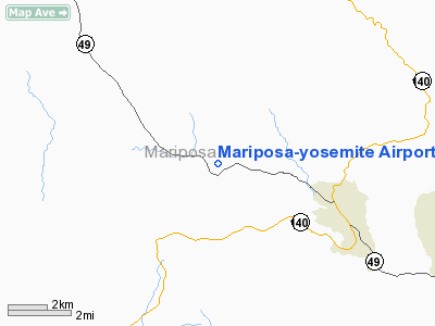
Mariposa-yosemite Airport |
| Mariposa-Yosemite Airport |
| IATA: none – ICAO: KMPI – FAA LID: MPI |
| Summary |
| Airport type |
Public |
| Owner |
County of Mariposa |
| Location |
Mariposa, California |
| Elevation AMSL |
2,254 ft / 687 m |
| Coordinates |
37°30′39″N 120°02′22″W / 37.51083°N 120.03944°W / 37.51083; -120.03944 |
| Runways |
| Direction |
Length |
Surface |
| ft |
m |
| 8/26 |
3,306 |
1,008 |
Asphalt |
| Statistics (2007) |
| Aircraft operations |
32,000 |
| Based aircraft |
52 |
| Source: Federal Aviation Administration |
Mariposa-Yosemite Airport (ICAO: KMPI, FAA LID: MPI, formerly O68) is a public airport located four miles (6 km) west of the central business district of Mariposa, in Mariposa County, California, United States. It is owned by the County of Mariposa.
Although most U.S. airports use the same three-letter location identifier for the FAA and IATA, Mariposa-Yosemite Airport is assigned MPI by the FAA but has no designation from the IATA (which assigned MPI to Mamitupo, Panama).
Facilities and aircraft
Mariposa-Yosemite Airport covers an area of 100 acres (40 ha) which contains one asphalt paved runway (8/26) measuring 3,306 x 60 ft (1,008 x 18 m).
For the 12-month period ending March 2, 2007, the airport had 32,000 aircraft operations, an average of 87 per day: 94% general aviation and 6% air taxi. There are 52 aircraft based at this airport: 96% single engine, 2% multi-engine and 2% ultralight.
The above content comes from Wikipedia and is published under free licenses – click here to read more.
Location
& QuickFacts
|
FAA
Information Effective: |
2006-09-28 |
|
Airport
Identifier: |
MPI |
|
Longitude/Latitude: |
120-02-22.3000W/37-30-39.1000N
-120.039528/37.510861 (Estimated) |
|
Elevation: |
2254 ft / 687.02 m (Surveyed) |
|
Land: |
100 acres |
|
From
nearest city: |
4 nautical miles W of Mariposa, CA |
|
Location: |
Mariposa County, CA |
|
Magnetic Variation: |
15E (1985) |
Owner
& Manager
|
Ownership: |
Publicly owned |
|
Owner: |
County Of Mariposa |
|
Address: |
4639 Ben Hur Road
Mariposa, CA 95338 |
|
Phone
number: |
209-966-5356 |
|
Manager: |
Maria Liddle |
|
Address: |
P.o. Box 786
Mariposa, CA 95338 |
|
Phone number: |
209-966-2143 |
Airport
Operations and Facilities
|
Airport
Use: |
Open to public |
|
Wind
indicator: |
Yes |
|
Segmented
Circle: |
Yes |
|
Control
Tower: |
No |
|
Attendance
Schedule: |
APR-NOV/ALL/0800-1700,DEC-MAR/ALL/0900-1600 |
|
Lighting
Schedule: |
DUSK-DAWN
ACTVT MIRL RY 08/26 - CTAF. |
|
Beacon
Color: |
Clear-Green (lighted land airport) |
|
Landing
fee charge: |
No |
|
Sectional
chart: |
San Francisco |
|
Region: |
AWP - Western-Pacific |
|
Traffic
Pattern Alt: |
1000 ft |
|
Boundary
ARTCC: |
ZOA - Oakland |
|
Tie-in
FSS: |
RIU - Rancho Murieta |
|
FSS
on Airport: |
No |
|
FSS
Phone: |
916-354-0161 |
|
FSS
Toll Free: |
1-800-WX-BRIEF |
|
NOTAMs
Facility: |
RIU (NOTAM-d service avaliable) |
|
Federal Agreements: |
NGY |
Airport
Communications
|
CTAF: |
122.700 |
|
Unicom: |
122.700 |
Airport
Services
|
Fuel
available: |
100LL80 |
|
Power
Plant Repair: |
MAJOR |
|
Bottled
Oxygen: |
NONE |
|
Bulk
Oxygen: |
NONE |
|
Runway Information
Runway 08/26
|
Dimension: |
3306 x 60 ft / 1007.7 x 18.3 m |
|
Surface: |
ASPH, Good Condition |
|
Weight
Limit: |
Single wheel: 12000 lbs. |
|
Edge
Lights: |
Medium |
|
|
Runway 08 |
Runway 26 |
|
Longitude: |
120-02-42.5598W |
120-02-02.1206W |
|
Latitude: |
37-30-41.8802N |
37-30-36.3816N |
|
Elevation: |
2254.00 ft |
2223.00 ft |
|
Alignment: |
100 |
127 |
|
Traffic
Pattern: |
Right |
Left |
|
Markings: |
Basic, Fair Condition |
Basic, Fair Condition |
|
Crossing
Height: |
20.00
ft |
21.00
ft |
|
VASI: |
2-box on left side |
2-box on left side |
|
Visual
Glide Angle: |
3.00� |
3.50� |
|
Runway
End Identifier: |
No |
No |
|
Centerline
Lights: |
No |
No |
|
Touchdown
Lights: |
No |
No |
|
Obstruction: |
45 ft tree, 1340.0 ft from runway, 130 ft right
of centerline, 25:1 slope to clear |
50 ft tree, 1100.0 ft from runway, 170 ft right
of centerline, 18:1 slope to clear |
|
Radio Navigation
Aids
|
ID |
Type |
Name |
Ch |
Freq |
Var |
Dist |
|
FCH |
NDB |
Chandler |
|
344.00 |
15E |
48.3 nm |
|
HYP |
VOR/DME |
El Nido |
089X |
114.20 |
15E |
24.6 nm |
|
MOD |
VOR/DME |
Modesto |
093X |
114.60 |
17E |
44.3 nm |
|
FRA |
VORTAC |
Friant |
103X |
115.60 |
17E |
32.4 nm |
|
CZQ |
VORTAC |
Clovis |
076X |
112.90 |
15E |
39.2 nm |
Remarks
- TRANSITIONAL
SURFACE OBSTRUCTION: MOUNTAINS TO NORTH OF RWY 08/26.
- ULTRALIGHT
OPNS ON INVOF ARPT.
- RY
08 TERRAIN DROPS ALONG BOTH SIDES OF TWY 45 FT FM RY EDGE.
Based Aircraft
|
Aircraft
based on field: |
52 |
|
Single
Engine Airplanes: |
50 |
|
Multi
Engine Airplanes: |
1 |
|
Ultralights: |
1 |
Operational Statistics
|
Aircraft
Operations: |
88/Day |
|
Air Taxi: |
6.3% |
|
General
Aviation Local: |
46.9% |
|
General
Aviation Itinerant: |
46.9% |
Mariposa-yosemite Airport
Address:
Mariposa County, CA
Tel:
209-966-5356,
209-966-2143
Images
and information placed above are from
http://www.airport-data.com/airport/MPI/
We
thank them for the data!
| General
Info |
| Country |
United
States |
| State |
CALIFORNIA
|
| FAA ID |
MPI
|
| Latitude |
37.510861
37� 30' 39.10" N |
| Longitude |
-120.039528
120� 02' 22.30" W |
| Elevation |
2254 feet
687 meters |
| Magnetic
Variation |
014� E
(01/06) |
| Beacon |
Yes
|
| Operating
Agency |
U.S.CIVIL
AIRPORT WHEREIN PERMIT COVERS USE BY TRANSIT MILITARY AIRCRAFT
|
| Alternate
Name |
MARIPOSA
COUNTY |
| Daylight
Savings Time |
First
Sunday in April at 0200 to last Sunday in October at 0200 local time
(Exception Arizona and that portion of Indiana in the Eastern Time
Zone) |
We don't guarantee the information is fresh and accurate. The data may
be wrong or outdated.
For more up-to-date information please refer to other sources.
|
|


