 |
|
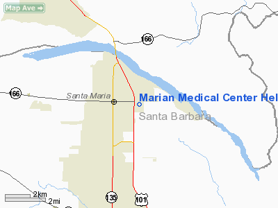
Marian Medical Center Heliport |
|
|
Location
& QuickFacts
|
FAA
Information Effective: |
2006-09-28 |
|
Airport
Identifier: |
1CL8 |
|
Longitude/Latitude: |
120-24-45.5860W/34-57-02.9210N
-120.412663/34.950811 (Estimated) |
|
Elevation: |
240 ft / 73.15 m (Estimated) |
|
Land: |
0 acres |
|
From
nearest city: |
0 nautical miles E of Santa Maria, CA |
|
Location: |
Santa Barbara County, CA |
|
Magnetic Variation: |
15E (1985) |
Owner
& Manager
|
Ownership: |
Privately owned |
|
Owner: |
Marian Medical Center |
|
Address: |
1400 East Church St
Santa Maria, CA 93454 |
|
Phone
number: |
805-922-5811 |
|
Manager: |
Wayne David Fastow |
|
Address: |
1400 East Church St
Santa Maria, CA 93454 |
|
Phone number: |
805-922-5821
EXT 683. |
Airport
Operations and Facilities
|
Airport
Use: |
Private
MEDICAL |
|
Wind
indicator: |
Yes |
|
Segmented
Circle: |
No |
|
Control
Tower: |
No |
|
Attendance
Schedule: |
UNATNDD |
|
Lighting
Schedule: |
PHONE REQ
FOR PERIMETER LGTS CALL 805-922-5821 EXT 687 |
|
Sectional
chart: |
Los Angeles |
|
Region: |
AWP - Western-Pacific |
|
Boundary
ARTCC: |
ZLA - Los Angeles |
|
Tie-in
FSS: |
HHR - Hawthorne |
|
FSS
Phone: |
310-970-0102 |
|
FSS
Toll Free: |
1-800-WX-BRIEF |
|
Runway Information
Helipad H1
|
Dimension: |
56 x 56 ft / 17.1 x 17.1 m |
|
Surface: |
CONC, |
|
|
Runway H1 |
Runway |
|
Traffic
Pattern: |
Left |
Left |
|
Radio Navigation
Aids
|
ID |
Type |
Name |
Ch |
Freq |
Var |
Dist |
|
VBG |
TACAN |
Vandenberg |
059Y |
|
15E |
15.6 nm |
|
GLJ |
VOR |
Guadalupe |
|
111.00 |
16E |
5.4 nm |
|
MQO |
VORTAC |
Morro Bay |
071X |
112.40 |
16E |
24.9 nm |
|
FLW |
VORTAC |
Fellows |
122X |
117.50 |
16E |
28.3 nm |
|
GVO |
VORTAC |
Gaviota |
085X |
113.80 |
16E |
29.8 nm |
|
RZS |
VORTAC |
San Marcus |
096X |
114.90 |
14E |
41.3 nm |
|
PRB |
VORTAC |
Paso Robles |
090X |
114.30 |
16E |
44.6 nm |
|
AVE |
VORTAC |
Avenal |
118X |
117.10 |
16E |
47.0 nm |
Remarks
- PRVD
VFR/PVT USE; & LOA IS ENTERED INTO WITH SANTA MARIA ATCT WHICH ADDRESSES
INGRESS/EGRESS ROUTES COMM REQUIREMENTS & THE SANTA MARIA ARPT HELICOPTER
PROCEDURES
Marian Medical Center Heliport
Address:
Santa Barbara County, CA
Tel:
805-922-5811
Images
and information placed above are from
http://www.airport-data.com/airport/1CL8/
We
thank them for the data!
| General
Info |
| Country |
United
States |
| State |
CALIFORNIA
|
| FAA ID |
1CL8
|
| Latitude |
34-57-02.921N
|
| Longitude |
120-24-45.586W
|
| Elevation |
240 feet
|
| Near City |
SANTA
MARIA |
We don't guarantee the information is fresh and accurate. The data may
be wrong or outdated.
For more up-to-date information please refer to other sources.
|
|


