 |
|
Lost Hills Kern County Airport |
Lost Hills Airport
Lost Hills-Kern County Airport |
| IATA: none – ICAO: none – FAA LID: L84 |
| Summary |
| Airport type |
Public |
| Operator |
Kern County |
| Location |
Lost Hills, California |
| Elevation AMSL |
274 ft / 83.5 m |
| Coordinates |
35°37′25″N 119°41′10″W / 35.62361°N 119.68611°W / 35.62361; -119.68611Coordinates: 35°37′25″N 119°41′10″W / 35.62361°N 119.68611°W / 35.62361; -119.68611 |
| Runways |
| Direction |
Length |
Surface |
| ft |
m |
| 15/33 |
3,020 |
920 |
Asphalt |
Lost Hills Airport (FAA LID: L84), also known as Lost Hills-Kern County Airport, is a public airport located one mile (2 km) northeast of the central business district (CBD) of Lost Hills, in Kern County, California, USA. The airport is mostly used for general aviation.
Facilities
Lost Hills Airport covers 390 acres (158 ha) and has one runway:
- Runway 15/33: 3,020 x 60 ft. (920 x 18 m), Surface: Asphalt
The above content comes from Wikipedia and is published under free licenses – click here to read more.
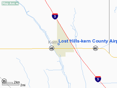
Location
& QuickFacts
|
FAA
Information Effective: |
2006-09-28 |
|
Airport
Identifier: |
L84 |
|
Longitude/Latitude: |
119-41-10.4580W/35-37-24.8550N
-119.686238/35.623571 (Estimated) |
|
Elevation: |
274 ft / 83.52 m (Estimated) |
|
Land: |
390 acres |
|
From
nearest city: |
1 nautical miles NE of Lost Hills, CA |
|
Location: |
Kern County, CA |
|
Magnetic Variation: |
15E (1985) |
Owner
& Manager
|
Ownership: |
Publicly owned |
|
Owner: |
County Of Kern Dept Of Airports |
|
Address: |
3701 Wings Way, Suite 300
Bakersfield, CA 93308-7026 |
|
Phone
number: |
661-391-1800 |
|
Manager: |
Jack Gotcher |
|
Address: |
3701 Wings Way, Suite 300
Bakersfield, CA 93308-7026 |
|
Phone
number: |
661-391-1800
CELL PHONE: (661) 747-4055 24 HRS: (661) 393-3868 FAX: (661)
391-1801 EMAIL: BFLSECURITY@CO.KERN.CA.US |
Airport
Operations and Facilities
|
Airport
Use: |
Open to public |
|
Wind
indicator: |
Yes |
|
Segmented
Circle: |
Yes |
|
Control
Tower: |
No |
|
Attendance
Schedule: |
UNATNDD |
|
Landing
fee charge: |
No |
|
Sectional
chart: |
Los Angeles |
|
Region: |
AWP - Western-Pacific |
|
Traffic
Pattern Alt: |
1000 ft |
|
Boundary
ARTCC: |
ZLA - Los Angeles |
|
Tie-in
FSS: |
RIU - Rancho Murieta |
|
FSS
on Airport: |
No |
|
FSS
Phone: |
916-354-0161 |
|
FSS
Toll Free: |
1-800-WX-BRIEF |
|
NOTAMs
Facility: |
RIU (NOTAM-d service avaliable) |
|
Federal Agreements: |
NP |
Airport
Communications
Airport
Services
|
Airframe
Repair: |
NONE |
|
Power
Plant Repair: |
NONE |
|
Bottled
Oxygen: |
NONE |
|
Bulk
Oxygen: |
NONE |
|
Runway Information
Runway 15/33
|
Dimension: |
3020 x 60 ft / 920.5 x 18.3 m |
|
Surface: |
ASPH, Poor Condition
CRACKING AND LOOSE GRAVEL ON RUNWAY |
|
Weight
Limit: |
Single wheel: 12000 lbs. |
|
|
Runway 15 |
Runway 33 |
|
Traffic
Pattern: |
Left |
Right |
|
Markings: |
Basic, Poor Condition
RUNWAY MARKINGS FADED |
Basic, Poor Condition
RUNWAY NUMBERS FADED |
|
Runway
End Identifier: |
No |
No |
|
Centerline
Lights: |
No |
No |
|
Touchdown
Lights: |
No |
No |
|
Obstruction: |
, 50:1 slope to clear
PVT AG RD 0' TO 125' FM END OF RY 60' L TO 0' L. |
40 ft poles, 1300.0 ft from runway, 200 ft
right of centerline, 27:1 slope to clear |
|
Radio Navigation
Aids
|
ID |
Type |
Name |
Ch |
Freq |
Var |
Dist |
|
COR |
NDB |
Salyer Farms |
|
205.00 |
16E |
27.6 nm |
|
NLC |
TACAN |
Lemoore |
080X |
|
16E |
45.4 nm |
|
TTE |
VOR/DME |
Tule |
029X |
109.20 |
16E |
36.8 nm |
|
VIS |
VOR/DME |
Visalia |
031X |
109.40 |
16E |
45.8 nm |
|
AVE |
VORTAC |
Avenal |
118X |
117.10 |
16E |
14.4 nm |
|
EHF |
VORTAC |
Shafter |
101X |
115.40 |
14E |
30.0 nm |
|
FLW |
VORTAC |
Fellows |
122X |
117.50 |
16E |
33.1 nm |
|
PRB |
VORTAC |
Paso Robles |
090X |
114.30 |
16E |
46.1 nm |
|
BFL |
VOT |
Bakersfield |
|
111.20 |
|
33.5 nm |
Remarks
- NO
AGRI FLTS EXCP BY PPR ARPT AMGR 661-393-7990.
Operational Statistics
|
Aircraft
Operations: |
20/Week |
|
General
Aviation Itinerant: |
100.0% |
Lost Hills-kern County Airport
Address:
Kern County, CA
Tel:
661-391-1800
Images
and information placed above are from
http://www.airport-data.com/airport/L84/
We
thank them for the data!
| General
Info |
| Country |
United
States |
| State |
CALIFORNIA
|
| FAA ID |
L84
|
| Latitude |
35-37-24.855N
|
| Longitude |
119-41-10.458W
|
| Elevation |
274 feet
|
| Near City |
LOST HILLS
|
We don't guarantee the information is fresh and accurate. The data may
be wrong or outdated.
For more up-to-date information please refer to other sources.
|
|


