 |
|
|
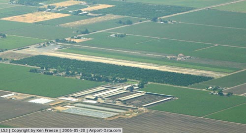 |
(Click on the photo to enlarge) |
|
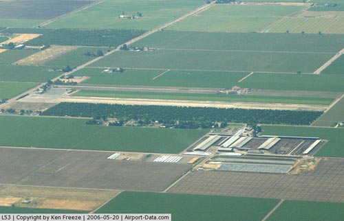 |
(Click on the photo to enlarge) |
Location
& QuickFacts
|
FAA
Information Effective: |
2006-09-28 |
|
Airport
Identifier: |
L53 |
|
Longitude/Latitude: |
121-18-58.8130W/38-05-02.7130N
-121.316337/38.084087 (Estimated) |
|
Elevation: |
25 ft / 7.62 m (Estimated) |
|
Land: |
51 acres |
|
From
nearest city: |
3 nautical miles SW of Lodi, CA |
|
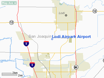
Location: |
San Joaquin County, CA |
|
Magnetic Variation: |
16E (1985) |
Owner
& Manager
|
Ownership: |
Privately owned |
|
Owner: |
Fredonyer Land Co Inc |
|
Address: |
11919 N Lower Sacramento Rd
Lodi, CA 95242 |
|
Phone
number: |
209-369-4408 |
|
Manager: |
Peter Precissi |
|
Address: |
11919 N Lower Sacramento Rd
Lodi, CA 95242 |
|
Phone number: |
209-369-4408 |
Airport
Operations and Facilities
|
Airport
Use: |
Open to public |
|
Wind
indicator: |
Yes |
|
Segmented
Circle: |
No |
|
Control
Tower: |
No |
|
Attendance
Schedule: |
JAN-SEP/ALL/0400-1500,OCT-DEC/MON-FRI/0600-1500 |
|
Landing
fee charge: |
No |
|
Sectional
chart: |
San Francisco |
|
Region: |
AWP - Western-Pacific |
|
Traffic
Pattern Alt: |
800 ft |
|
Boundary
ARTCC: |
ZOA - Oakland |
|
Tie-in
FSS: |
RIU - Rancho Murieta |
|
FSS
on Airport: |
No |
|
FSS
Phone: |
916-354-0161 |
|
FSS
Toll Free: |
1-800-WX-BRIEF |
|
NOTAMs
Facility: |
RIU (NOTAM-d service avaliable) |
Airport
Communications
Airport
Services
|
Fuel
available: |
100LL |
|
Airframe
Repair: |
MINOR |
|
Power
Plant Repair: |
MINOR |
|
Bottled
Oxygen: |
NONE |
|
Bulk
Oxygen: |
NONE |
|
Runway Information
Runway 07/25
|
Dimension: |
1875 x 22 ft / 571.5 x 6.7 m |
|
Surface: |
ASPH, Good Condition |
|
|
Runway 07 |
Runway 25 |
|
Traffic
Pattern: |
Left |
Left |
|
Markings: |
Basic, Good Condition |
Basic, Good Condition |
|
Runway
End Identifier: |
No |
No |
|
Centerline
Lights: |
No |
No |
|
Touchdown
Lights: |
No |
No |
|
Obstruction: |
12 ft road, 100.0 ft from runway |
6 ft , 260.0 ft from runway, 90 ft left of
centerline, 10:1 slope to clear |
|
Radio Navigation
Aids
|
ID |
Type |
Name |
Ch |
Freq |
Var |
Dist |
|
TCY |
NDB |
Tracy |
|
203.00 |
15E |
24.3 nm |
|
LV |
NDB |
Reiga |
|
374.00 |
16E |
29.3 nm |
|
SUU |
TACAN |
Travis |
113X |
|
17E |
31.3 nm |
|
TZZ |
VOR |
Travis |
|
116.40 |
17E |
28.1 nm |
|
MOD |
VOR/DME |
Modesto |
093X |
114.60 |
17E |
32.3 nm |
|
CCR |
VOR/DME |
Concord |
117X |
117.00 |
17E |
34.6 nm |
|
MCC |
VOR/DME |
Mc Clellan |
029X |
109.20 |
17E |
35.3 nm |
|
HNW |
VOR/DME |
Hangtown |
102X |
115.50 |
17E |
46.9 nm |
|
LIN |
VORTAC |
Linden |
095X |
114.80 |
17E |
14.8 nm |
|
ECA |
VORTAC |
Manteca |
107X |
116.00 |
17E |
16.5 nm |
|
SAC |
VORTAC |
Sacramento |
099X |
115.20 |
17E |
24.3 nm |
|
OAK |
VORTAC |
Oakland |
115X |
116.80 |
17E |
48.1 nm |
|
SAC |
VOT |
Sacramento Executive |
|
111.40 |
|
27.2 nm |
|
SMF |
VOT |
Sacramento Metropolitan |
|
111.40 |
|
38.7 nm |
Remarks
- 370'
APRON EXTENDS EAST FROM ENDS OF RWYS.
- ULTRALIGHTS
PROHIBITED.
- ESTABD
PRIOR TO 15 MAY 1959.
Based Aircraft
|
Aircraft
based on field: |
7 |
|
Single
Engine Airplanes: |
7 |
Operational Statistics
|
Aircraft
Operations: |
139/Week |
|
General
Aviation Local: |
97.2% |
|
General
Aviation Itinerant: |
2.8% |
Lodi Airpark Airport
Address:
San Joaquin County, CA
Tel:
209-369-4408
Images
and information placed above are from
http://www.airport-data.com/airport/L53/
We
thank them for the data!
We don't guarantee the information is fresh and accurate. The data may
be wrong or outdated.
For more up-to-date information please refer to other sources.
|
|


