|
|
Livermore Municipal Airport |
| Livermore Municipal Airport |
 |
| IATA: LVK – ICAO: KLVK |
| Summary |
| Airport type |
Public |
| Operator |
City of Livermore |
| Location |
Livermore, California |
| Elevation AMSL |
400 ft / 121.9 m |
| Coordinates |
37°41′36.2″N 121°49′13.3″W / 37.693389°N 121.820361°W / 37.693389; -121.820361Coordinates: 37°41′36.2″N 121°49′13.3″W / 37.693389°N 121.820361°W / 37.693389; -121.820361 |
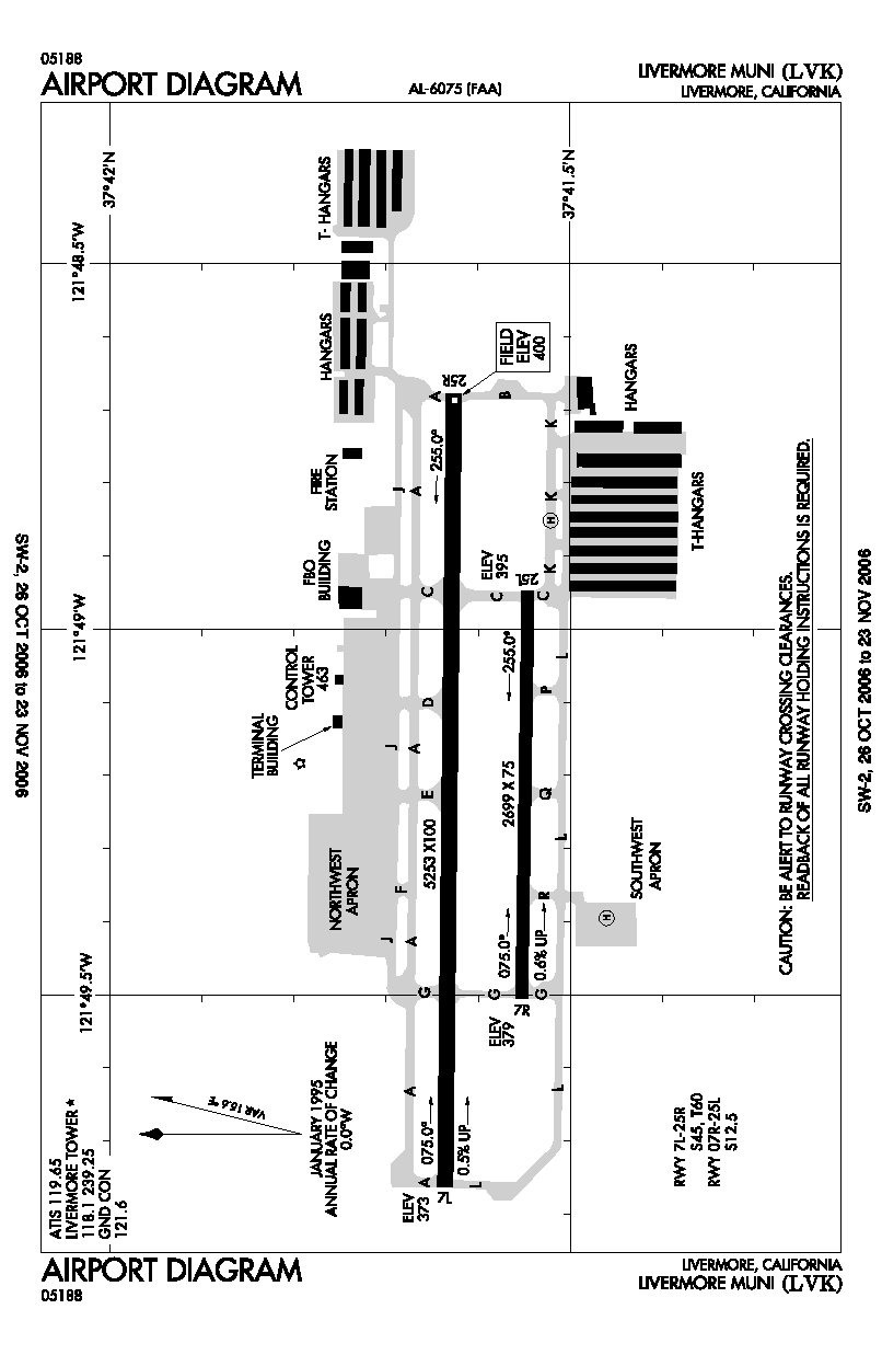
| Runways |
| Direction |
Length |
Surface |
| ft |
m |
| 7L/25R |
5,253 |
1,601 |
Asphalt |
| 7R/25L |
2,699 |
823 |
Asphalt |
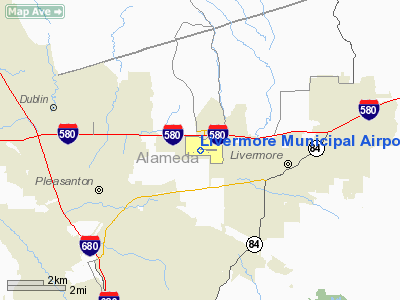
Livermore Municipal Airport (IATA: LVK, ICAO: KLVK) is located in Livermore, California, USA, east of the San Francisco Bay between San Jose and Oakland.
Sierra Academy of Aeronautics operated one of its training centers on the north ramp until December 2007. Other flight schools at Livermore Municipal Airport are Ahart Aviation Inc., Attitude Aviation and Red Sky Aviation. History
The current terminal building was built in 1969.
The above content comes from Wikipedia and is published under free licenses – click here to read more.
Location
& QuickFacts
|
FAA
Information Effective: |
2006-09-28 |
|
Airport
Identifier: |
LVK |
|
Longitude/Latitude: |
121-49-13.3000W/37-41-36.2000N
-121.820361/37.693389 (Estimated) |
|
Elevation: |
400 ft / 121.92 m (Surveyed) |
|
Land: |
643 acres |
|
From
nearest city: |
3 nautical miles W of Livermore, CA |
|
Location: |
Alameda County, CA |
|
Magnetic Variation: |
16E (1985) |
Owner
& Manager
|
Ownership: |
Publicly owned |
|
Owner: |
City Of Livermore |
|
Address: |
1052 South Livermore Ave
Livermore, CA 94550 |
|
Phone number: |
925-960-4200 |
|
Manager: |
Leander Hauri |
|
Address: |
636 Terminal Circle
Livermore, CA 94551 |
|
Phone number: |
925-373-5280 |
Airport
Operations and Facilities
|
Airport
Use: |
Open to public |
|
Wind
indicator: |
Yes |
|
Segmented
Circle: |
Yes |
|
Control
Tower: |
Yes |
|
Attendance
Schedule: |
ALL/ALL/0800-DUSK |
|
Lighting
Schedule: |
DUSK-DAWN
ACTVT MALSR RY 25R AND TWY LGTS WHEN ATCT CLSD - 118.1 |
|
Beacon
Color: |
Clear-Green (lighted land airport) |
|
Landing
fee charge: |
No |
|
Sectional
chart: |
San Francisco |
|
Region: |
AWP - Western-Pacific |
|
Traffic
Pattern Alt: |
1000 ft |
|
Boundary
ARTCC: |
ZOA - Oakland |
|
Tie-in
FSS: |
OAK - Oakland |
|
FSS
on Airport: |
No |
|
FSS
Phone: |
510-273-6111 |
|
FSS
Toll Free: |
1-800-WX-BRIEF |
|
NOTAMs
Facility: |
LVK (NOTAM-d service avaliable) |
|
Federal Agreements: |
NGY |
Airport
Communications
|
CTAF: |
118.100 |
|
Unicom: |
122.950 |
Airport
Services
|
Fuel
available: |
100LLA |
|
Airframe
Repair: |
MAJOR |
|
Power
Plant Repair: |
MAJOR |
|
Bottled
Oxygen: |
HIGH |
|
Bulk
Oxygen: |
HIGH |
|
Runway
Information
Runway 07L/25R
|
Dimension: |
5253 x 100 ft / 1601.1 x 30.5 m |
|
Surface: |
ASPH, Good Condition |
|
Weight
Limit: |
Single wheel: 45000 lbs.
Dual wheel: 60000 lbs. |
|
Edge
Lights: |
Medium |
|
|
Runway 07L |
Runway 25R |
|
Longitude: |
121-49-45.8414W |
121-48-40.4963W |
|
Latitude: |
37-41-38.1690N |
37-41-37.6538N |
|
Elevation: |
373.00 ft |
400.00 ft |
|
Alignment: |
90 |
127 |
|
ILS
Type: |
|
ILS |
|
Traffic
Pattern: |
Left |
Right |
|
Markings: |
Non-precision instrument, Good Condition |
Precision instrument, Good Condition |
|
Crossing
Height: |
32.00 ft |
48.00 ft |
|
VASI: |
4-light PAPI on right side |
4-box on left side |
|
Visual
Glide Angle: |
4.00� |
3.00� |
|
Obstruction: |
27 ft pole, 650.0 ft from runway, 420 ft right
of centerline, 16:1 slope to clear
+6 FT FENCE 180 FT FM RY END 400 FT LEFT OF EXTDD CNTRLN. |
20 ft trees, 700.0 ft from runway, 250 ft left
of centerline, 25:1 slope to clear |
|
Runway 07R/25L
|
Dimension: |
2699 x 75 ft / 822.7 x 22.9 m |
|
Surface: |
ASPH, Good Condition |
|
Weight
Limit: |
Single wheel: 12500 lbs. |
|
|
Runway 07R |
Runway 25L |
|
Longitude: |
121-49-30.3151W |
121-48-56.7363W |
|
Latitude: |
37-41-33.1092N |
37-41-32.8364N |
|
Elevation: |
379.00 ft |
395.00 ft |
|
Alignment: |
90 |
127 |
|
Traffic
Pattern: |
Right |
Left |
|
Markings: |
Basic, Fair Condition |
Basic, Fair Condition |
|
Radio Navigation
Aids
|
ID |
Type |
Name |
Ch |
Freq |
Var |
Dist |
|
LV |
NDB |
Reiga |
|
374.00 |
16E |
6.5 nm |
|
TCY |
NDB |
Tracy |
|
203.00 |
15E |
17.9 nm |
|
PDG |
NDB |
Pajar |
|
327.00 |
17E |
46.9 nm |
|
NUQ |
TACAN |
Moffett |
123X |
|
17E |
19.3 nm |
|
SUU |
TACAN |
Travis |
113X |
|
17E |
33.7 nm |
|
TZZ |
VOR |
Travis |
|
116.40 |
17E |
39.1 nm |
|
SJC |
VOR/DME |
San Jose |
088X |
114.10 |
16E |
20.1 nm |
|
CCR |
VOR/DME |
Concord |
117X |
117.00 |
17E |
23.7 nm |
|
SFO |
VOR/DME |
San Francisco |
105X |
115.80 |
17E |
26.7 nm |
|
MOD |
VOR/DME |
Modesto |
093X |
114.60 |
17E |
41.2 nm |
|
OAK |
VORTAC |
Oakland |
115X |
116.80 |
17E |
19.3 nm |
|
OSI |
VORTAC |
Woodside |
086X |
113.90 |
17E |
28.5 nm |
|
ECA |
VORTAC |
Manteca |
107X |
116.00 |
17E |
32.0 nm |
|
SAU |
VORTAC |
Sausalito |
109X |
116.20 |
17E |
34.8 nm |
|
SGD |
VORTAC |
Scaggs Island |
058X |
112.10 |
17E |
39.2 nm |
|
LIN |
VORTAC |
Linden |
095X |
114.80 |
17E |
45.0 nm |
|
SAC |
VORTAC |
Sacramento |
099X |
115.20 |
17E |
46.9 nm |
|
SFO |
VOT |
San Francisco Intl |
|
111.00 |
|
26.8 nm |
Remarks
- CAUTION
CONSIDERABLE BIRD ACTIVITY ON & IN VICINITY OF ARPT.
- DO
NOT MISTAKE PARALLEL TAXIWAY N OF RWY 25R/7L AS RWY. NOISE SENSITIVE
AREAS 3/4 MILE EAST & 2 MILES W OF ARPT.
- EFFECTIVE
RY GRADIENT RY 07L 0.52% UP; RY 07R 0.59% UP.
Based Aircraft
|
Aircraft
based on field: |
604 |
|
Single
Engine Airplanes: |
534 |
|
Multi
Engine Airplanes: |
65 |
|
Jet Engine
Airplanes: |
2 |
|
Helicopters: |
3 |
Operational Statistics
|
Aircraft
Operations: |
645/Day |
|
Air Taxi: |
0.7% |
|
General
Aviation Local: |
62.4% |
|
General
Aviation Itinerant: |
36.8% |
|
Military: |
0.1% |
Livermore Municipal Airport
Address:
Alameda County, CA
Tel:
925-960-4200, 925-373-5280
Images
and information placed above are from
http://www.airport-data.com/airport/LVK/
We
thank them for the data!
| General
Info |
| Country |
United
States |
| State |
CALIFORNIA
|
| FAA ID |
LVK
|
| Latitude |
37-41-36.200N
|
| Longitude |
121-49-13.300W
|
| Elevation |
397 feet
|
| Near City |
LIVERMORE
|
We don't guarantee the information is fresh and accurate. The data may
be wrong or outdated.
For more up-to-date information please refer to other sources.
|
|