 |
|
| Lampson Field |
| IATA: none – ICAO: none – FAA LID: 1O2 |
| Summary |
| Airport type |
Public |
| Operator |
Lake County Public Works |
| Location |
Lake County, California |
| Elevation AMSL |
1,379 ft / 420 m |
| Coordinates |
38°59′26″N 122°54′02″W / 38.99056°N 122.90056°W / 38.99056; -122.90056Coordinates: 38°59′26″N 122°54′02″W / 38.99056°N 122.90056°W / 38.99056; -122.90056 |
| Runways |
| Direction |
Length |
Surface |
| ft |
m |
| 10/28 |
3,597 |
1,096 |
Asphalt |
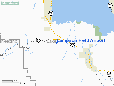
Lampson Field (FAA LID: 1O2) is a public airport located three miles (4.8 km) south of the town of Lakeport, in Lake County, California, USA. Features of the airport include 4.0 degree Precision Approach Path Indicator (PAPI) lights on runway 28, Pilot Controlled Lighting and an Automated Weather Observing System (AWOS). The airport covers 68 acres (280,000 m) and has one runway.
The above content comes from Wikipedia and is published under free licenses – click here to read more.
Location
& QuickFacts
|
FAA
Information Effective: |
2006-09-28 |
|
Airport
Identifier: |
1O2 |
|
Longitude/Latitude: |
122-54-02.6000W/38-59-26.2000N
-122.900722/38.990611 (Estimated) |
|
Elevation: |
1379 ft / 420.32 m (Estimated) |
|
Land: |
68 acres |
|
From
nearest city: |
3 nautical miles S of Lakeport, CA |
|
Location: |
Lake County, CA |
|
Magnetic Variation: |
16E (1990) |
Owner
& Manager
|
Ownership: |
Publicly owned |
|
Owner: |
Lake County |
|
Address: |
255 N Forbes St
Lakeport, CA 95453 |
|
Phone
number: |
707-263-2341 |
|
Manager: |
Kurt Ackermann |
|
Address: |
255 N Forbes St
Lakeport, CA 95453 |
|
Phone
number: |
707-263-2341
PRINCIPAL CIVIL ENGINEER; OFFICE IN LAKEPORT, CA. |
Airport
Operations and Facilities
|
Airport
Use: |
Open to public |
|
Wind
indicator: |
Yes |
|
Segmented
Circle: |
Yes |
|
Control
Tower: |
No |
|
Attendance
Schedule: |
ALL/ALL/0800-1700 |
|
Lighting
Schedule: |
DUSK-DAWN
ACTVT MIRL RY 10/28 - CTAF. |
|
Beacon
Color: |
Clear-Green (lighted land airport) |
|
Landing
fee charge: |
No |
|
Sectional
chart: |
San Francisco |
|
Region: |
AWP - Western-Pacific |
|
Traffic
Pattern Alt: |
800 ft |
|
Boundary
ARTCC: |
ZOA - Oakland |
|
Tie-in
FSS: |
OAK - Oakland |
|
FSS
on Airport: |
No |
|
FSS
Phone: |
510-273-6111 |
|
FSS
Toll Free: |
1-800-WX-BRIEF |
|
NOTAMs
Facility: |
OAK (NOTAM-d service avaliable) |
|
Federal Agreements: |
NGY |
Airport
Communications
|
CTAF: |
122.800 |
|
Unicom: |
122.800 |
Airport
Services
|
Fuel
available: |
100LL |
|
Airframe
Repair: |
MAJOR |
|
Power
Plant Repair: |
MAJOR |
|
Bottled
Oxygen: |
NONE |
|
Bulk
Oxygen: |
NONE |
|
Runway Information
Runway 10/28
|
Dimension: |
3597 x 60 ft / 1096.4 x 18.3 m |
|
Surface: |
ASPH, Good Condition |
|
Weight
Limit: |
Single wheel: 30000 lbs. |
|
Edge
Lights: |
Medium |
|
|
Runway 10 |
Runway 28 |
|
Longitude: |
122-54-22.5000W |
122-53-42.7000W |
|
Latitude: |
38-59-34.8000N |
38-59-17.5000N |
|
Elevation: |
1379.00 ft |
1368.00 ft |
|
Alignment: |
119 |
127 |
|
Traffic
Pattern: |
Left |
Right |
|
Markings: |
Basic, Good Condition |
Basic, Good Condition |
|
Crossing
Height: |
0.00
ft |
40.00 ft |
|
Displaced
threshold: |
0.00
ft |
85.00 ft |
|
VASI: |
|
2-light PAPI on left side |
|
Visual
Glide Angle: |
0.00� |
4.00� |
|
Runway
End Identifier: |
No |
No |
|
Centerline
Lights: |
No |
No |
|
Touchdown
Lights: |
No |
No |
|
Obstruction: |
30 ft trees, 700.0 ft from runway, 290 ft right
of centerline, 16:1 slope to clear |
15 ft road, 236.0 ft from runway, 133 ft right
of centerline, 2:1 slope to clear
APCH RATIO TO DSPLCD THR 21:1. |
|
Radio Navigation
Aids
|
ID |
Type |
Name |
Ch |
Freq |
Var |
Dist |
|
LOP |
NDB |
Lampson |
|
217.00 |
16E |
0.8 nm |
|
STS |
VOR/DME |
Santa Rosa |
077X |
113.00 |
16E |
29.3 nm |
|
ENI |
VORTAC |
Mendocino |
070X |
112.30 |
16E |
17.8 nm |
|
MXW |
VORTAC |
Maxwell |
037X |
110.00 |
18E |
37.3 nm |
|
ILA |
VORTAC |
Williams |
091X |
114.40 |
18E |
41.1 nm |
Remarks
- UNICOM
OPER AVBL MON-FRI 0700-1600.
Based Aircraft
|
Aircraft
based on field: |
111 |
|
Single
Engine Airplanes: |
100 |
|
Multi
Engine Airplanes: |
10 |
|
Helicopters: |
1 |
Operational Statistics
|
Aircraft
Operations: |
210/Day |
|
General
Aviation Local: |
48.4% |
|
General
Aviation Itinerant: |
48.4% |
|
Military: |
3.3% |
Lampson Field Airport
Address:
Lake County, CA
Tel:
707-263-2341
Images
and information placed above are from
http://www.airport-data.com/airport/1O2/
We
thank them for the data!
| General
Info |
| Country |
United
States |
| State |
CALIFORNIA
|
| FAA ID |
1O2
|
| Latitude |
38-59-24.629N
|
| Longitude |
122-53-58.983W
|
| Elevation |
1378 feet
|
| Near City |
LAKEPORT
|
We don't guarantee the information is fresh and accurate. The data may
be wrong or outdated.
For more up-to-date information please refer to other sources.
|
|


