 |
|
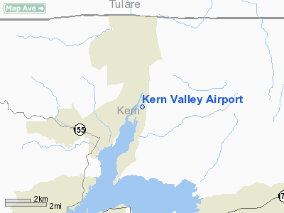
| Kern Valley Airport |
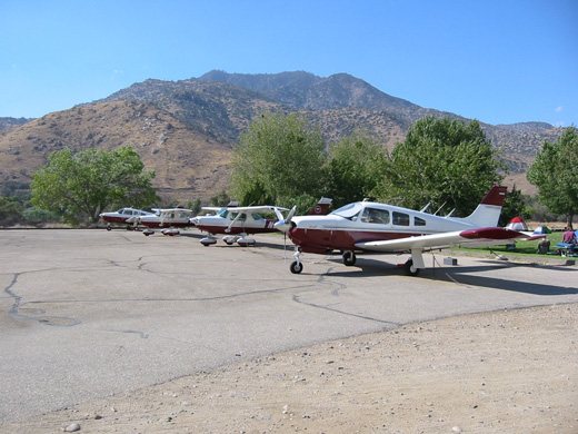 |
| Mt SAC Flying Team annual practice at L05 |
| IATA: none – ICAO: none – FAA LID: L05 |
| Summary |
| Airport type |
Public |
| Operator |
County of Kern |
| Location |
Kernville, California |
| Elevation AMSL |
2,614 ft / 796.7 m |
| Coordinates |
35°43′42″N 118°25′11″W / 35.72833°N 118.41972°W / 35.72833; -118.41972Coordinates: 35°43′42″N 118°25′11″W / 35.72833°N 118.41972°W / 35.72833; -118.41972 |
| Runways |
| Direction |
Length |
Surface |
| ft |
m |
| 17/35 |
3,500 |
1,067 |
Asphalt |
Kern Valley Airport (FAA LID: L05) is a public airport located three miles (4.8 km) south of Kernville, serving Kern County, California, USA. The airport is mostly used for general aviation. Facilities
Kern Valley Airport covers 270 acres (109 ha) and has one runway:
- Runway 17/35: 3,500 x 50 ft. (1,067 x 15 m), Surface: Asphalt
Use
Average of 28 operations per day.
| Commercial |
Air Taxi |
GA Local |
GA Transient |
Military |
| 0 |
0 |
14 |
14 |
0 |
20 aircraft based at airport
| Single Engine |
Multi Engine |
Jet |
Helicopter |
Glider/ Ultralight |
Military |
| 20 |
0 |
0 |
0 |
0 |
0 |
The above content comes from Wikipedia and is published under free licenses – click here to read more.
Location
& QuickFacts
|
FAA
Information Effective: |
2006-09-28 |
|
Airport
Identifier: |
L05 |
|
Longitude/Latitude: |
118-25-11.3050W/35-43-41.8250N
-118.419807/35.728285 (Estimated) |
|
Elevation: |
2614 ft / 796.75 m (Surveyed) |
|
Land: |
270 acres |
|
From
nearest city: |
3 nautical miles S of Kernville, CA |
|
Location: |
Kern County, CA |
|
Magnetic Variation: |
14E (1985) |
Owner
& Manager
|
Ownership: |
Publicly owned |
|
Owner: |
County Of Kern Dept Of Airports
OWNED BY US FOREST SVC ON LEASE TO KERN COUNTY. |
|
Address: |
3701 Wings Way, Suite 300
Bakersfield, CA 93308-7026 |
|
Phone
number: |
661-391-1800 |
|
Manager: |
Jack Gotcher
CONTACT: JACK GOTCHER, DEPUTY DIRECTOR 661-391-1800; ON
AIRPORT FOR OPERATOR, G. NELSON, OR CALL 619-376-2852. |
|
Address: |
3701 Wings Way, Suite 300
Bakersfield, CA 93308-7026 |
|
Phone number: |
661-391-1800
CELL PHONE 661-747-4053 |
Airport
Operations and Facilities
|
Airport
Use: |
Open to public |
|
Wind
indicator: |
Yes |
|
Segmented
Circle: |
Yes |
|
Control
Tower: |
No |
|
Attendance
Schedule: |
ALL/ALL/DALGT |
|
Landing
fee charge: |
No |
|
Sectional
chart: |
Los Angeles |
|
Region: |
AWP - Western-Pacific |
|
Traffic
Pattern Alt: |
1000 ft |
|
Boundary
ARTCC: |
ZLA - Los Angeles |
|
Tie-in
FSS: |
RIU - Rancho Murieta |
|
FSS
on Airport: |
No |
|
FSS
Phone: |
916-354-0161 |
|
FSS
Toll Free: |
1-800-WX-BRIEF |
|
NOTAMs
Facility: |
RIU (NOTAM-d service avaliable) |
|
Federal Agreements: |
N |
Airport
Communications
|
CTAF: |
122.800 |
|
Unicom: |
122.800 |
Airport
Services
|
Fuel
available: |
100LL |
|
Airframe
Repair: |
MINOR |
|
Power
Plant Repair: |
MINOR |
|
Bottled
Oxygen: |
NONE |
|
Bulk
Oxygen: |
NONE |
|
Runway Information
Runway 17/35
|
Dimension: |
3500 x 50 ft / 1066.8 x 15.2 m |
|
Surface: |
ASPH, Good Condition |
|
|
Runway 17 |
Runway 35 |
|
Traffic
Pattern: |
Right |
Left |
|
Markings: |
Basic, Good Condition |
Basic, Good Condition |
|
Runway
End Identifier: |
No |
No |
|
Centerline
Lights: |
No |
No |
|
Touchdown
Lights: |
No |
No |
|
Obstruction: |
10 ft trees, 375.0 ft from runway, 100 ft right
of centerline, 17:1 slope to clear |
, 50:1 slope to clear
RWY 35 +1 FT ROCKS O-90 FT FM EOR 50 FT L TO 80 FT R PRVDG
WASHOUT PROTECTION FM LAKE; +5 FT BRUSH 180-200 FT FM EOR
0 FT L. |
|
Radio Navigation
Aids
|
ID |
Type |
Name |
Ch |
Freq |
Var |
Dist |
|
NID |
TACAN |
China Lake |
053X |
|
16E |
35.7 nm |
|
TTE |
VOR/DME |
Tule |
029X |
109.20 |
16E |
31.3 nm |
|
EHF |
VORTAC |
Shafter |
101X |
115.40 |
14E |
36.2 nm |
|
BFL |
VOT |
Bakersfield |
|
111.20 |
|
35.7 nm |
Remarks
- <
NIGHT>
- KERN
VALLEY PAINTED ON CENTER OF RWY.
- FLY-IN
CAMPGROUND ON ARPT.
Based Aircraft
|
Aircraft
based on field: |
30 |
|
Single
Engine Airplanes: |
30 |
Operational Statistics
|
Aircraft
Operations: |
202/Week |
|
General
Aviation Local: |
48.8% |
|
General
Aviation Itinerant: |
48.8% |
|
Military: |
2.4% |
Kern Valley Airport
Address:
Kern County, CA
Tel:
661-391-1800,
661-747-4053
Images
and information placed above are from
http://www.airport-data.com/airport/L05/
We
thank them for the data!
| General
Info |
| Country |
United
States |
| State |
CALIFORNIA
|
| FAA ID |
L05
|
| Latitude |
35-43-41.825N
|
| Longitude |
118-25-11.305W
|
| Elevation |
2614 feet
|
| Near City |
KERNVILLE
|
We don't guarantee the information is fresh and accurate. The data may
be wrong or outdated.
For more up-to-date information please refer to other sources.
|
|


