|
 |
|
||||
|
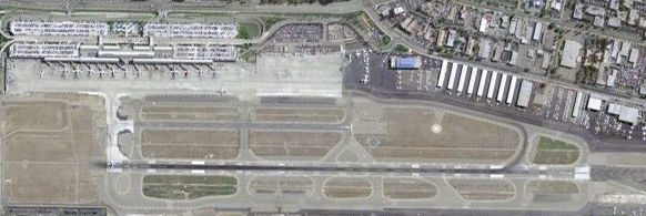
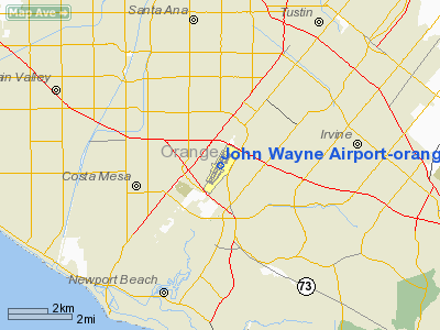
John Wayne Airport (IATA: SNA, ICAO: KSNA, FAA LID: SNA) is an airport in an unincorporated area in Orange County, California, with its mailing address in Santa Ana, hence the International Air Transport Association (IATA) airport code. The main entrance to the airport is off of MacArthur Blvd in Irvine, the city that surrounds the southern and eastern part of the airport. Newport Beach is to the west of the airport and Costa Mesa and Santa Ana are to the north of the airport. Originally named Orange County Airport, the county Board of Supervisors renamed it in 1979 to honor the actor John Wayne, who resided in nearby Newport Beach and died that year. It also became the first airport to be named after an entertainer. The main runway, at 5,701 feet (1,738 m), is one of the shortest of any major airport in the United States, resulting in most passenger aircraft operating from the airport to be no larger than the Boeing 757. However, some larger cargo aircraft, such as the FedEx A310/300, fly from SNA. Some gates are built to handle planes up to the size of a Boeing 767, which can operate with payload/fuel load restrictions. No wide body passenger aircraft are currently in scheduled service at the airport. John Wayne Airport is the sole commercial airport within Orange County. General aviation operations outnumber commercial operations and several facilities at the airport serve the general aviation and corporate aviation community. The other general aviation airport within the county is Fullerton Municipal Airport. Other commercial airports within close proximity are Long Beach Airport, followed by Los Angeles International Airport and LA/Ontario International Airport. In 2008, John Wayne Airport was the second busiest airport in the area (by passenger count) with almost 9 million total passengers. The most prominent airlines at John Wayne Airport are Southwest Airlines, American Airlines, United Airlines, and Alaska Airlines. John Wayne Airport is 14 miles (23 km) from Orange County's signature attraction - the Disneyland Resort. By contrast, Los Angeles International Airport is 35 miles (56 km) from Disneyland. A statue of the airport's namesake welcomes passengers passing through the arrivals area on the lower level. The airport is served by OCTA buses #76 and #212, as well as the Irvine Shuttle route A. History
The first airstrip on the grounds was constructed in 1923, when Eddie Martin founded a flying school on land owned by the Irvine Company. It was purchased through a land swap by the County of Orange in 1939 and remains under the County's ownership and management. After serving as a military base during World War II, it was returned by the federal government to the County with the stipulation that it remain open to all kinds of aviation uses. During the 1950s the only airline flights were Bonanza's few flights between Los Angeles and Phoenix, via San Diego. In 1963 Bonanza started nonstop F27s to Phoenix, and to Las Vegas in 1965; in 1967 Air California started Electras nonstop to San Francisco, 48 flights a week each way. The first scheduled jet flights were Bonanza DC-9s later in 1967. In 1967, the 22,000-square-foot (2,000 m) Eddie Martin Terminal was constructed to accommodate 400,000 annual passengers. Remodeling added two passenger holding areas in 1974, a new baggage claim area in 1980 and a terminal annex building in 1982, bringing the facility to 29,000 square feet (2,700 m). Nonstop flights reached Salt Lake City in 1976-77 (Hughes DC9s), Denver in 1982 (Frontier MD80s), Dallas-FtWorth in 1983 (American MD80s), Chicago in 1986 (AirCal 737-300s), and New York Kennedy in 1991 (America West 757s). After the Orange County Airport was renamed the John Wayne Airport in 1979, Arrival and Departure Monitors in airports throughout the country continued to identify the airport as Orange County, which is the nickname for the OMB Metropolitan Designation, Santa Ana-Anaheim-Irvine, California. To commemorate the Airport's namesake, the John Wayne Associates commissioned sculptor Robert Summers to create nine-foot bronze statue of "the Duke." The nine-foot statue, created at Hoka Hey Foundry in Dublin, Texas, was dedicated to the County on November 4, 1982. Today, the bronze statue is located in the Thomas F. Riley Terminal on the Arrival Level. In 1990, the Thomas F. Riley Terminal opened to the public. The aging 29,000-square-foot (2,700 m) Eddie Martin Terminal was replaced with a modern 337,900-square-foot (31,390 m) facility. The new facility included 14 loading bridges, four baggage carousels, wide open spaces and distinct roadside arrival and departure levels. In 1994, the then-unused Eddie Martin Terminal was demolished. In the late 1990s and early 2000s, a new airport was proposed on the nearby site of the former El Toro Marine Corps Air Station. After a prolonged battle, however, the proposal was defeated and no new airport was built. In 2004, Chris Norby, a member of the county Board of Supervisors, proposed changing the airport's name to The O.C. Airport, John Wayne Field, in light of the popularity of the TV series The O.C. He withdrew the idea after receiving negative publicity and angry responses from numerous local residents. On March 31, 2008, Aloha Airlines, which began air service to the Hawaiian Islands in 2001, ended all of its passenger operations at the airport. This has left a void in air service, nonstop from SNA, to Hawaii, a popular tourist destination for Southern California residents. In addition to the Hawaiian Islands, Aloha Airlines served Reno and Sacramento from SNA. As a result of Aloha Airline's pullout and fleet reductions within American Airlines, United Airlines, and Continental Airlines, the airport considered opening up two slots as of June 7, 2008. According to Orange County's local newspaper, The Orange County Register, the top two candidates for the slots were Air Canada and Hawaiian Airlines. An Air Canada spokesperson said that it was not in a position at the time to be making a big decision. A Hawaiian Airlines spokesperson said that, although it had an interest in operating from John Wayne Airport, it was most likely that it wouldn't take the slot since it was trying to concentrate on its routes from the nearby Los Angeles International Airport. Furthermore, Hawaiian Airlines primarily flies Boeing 767 aircraft, which the current airport facilities could only accommodate with payload/fuel load restrictions. On April 29, 2009, Virgin America began service between San Francisco and Orange County. The service directly competed with both Southwest Airlines and United Express. The airline ended service to San Francisco 13 months later, on May 26, 2010. On October 7, 2009, Continental Airlines announced it would begin daily service to Honolulu on March 7, 2010, and Maui using the Boeing 737-700. On April 9, 2010, Air Canada began operating flights to Toronto—currently the only international flights to and from Orange County. In July 2010, The airport began offering free Wi-Fi internet to passengers. Airfield information
John Wayne Airport covers 500.82 acres of land. The airport has multiple general aviation facilities, a main commercial airline building split into two terminal areas, and 2 paved runways.
Aircraft noise abatement and curfewA 1985 settlement agreement defined the scope of operation for John Wayne Airport in how it affects the local community. The area that lies directly South of John Wayne Airport is considered a noise sensitive area. The agreement in conjunction with a Phase 2 Commercial Airline Access Plan and Regulation controls the number of noisier operations (mainly commercial aircraft) allowed from the airport. Noise abatement enforcement is carried out with the aid of 10 permanent noise monitoring stations. These stations are placed in areas that exceed a Community Noise Equivalent Level (CNEL) of 65 dB. The short primary runway (19R/1L), coupled with the local noise restrictions, can require a takeoff at or near full power (95-97% power). Some aircraft departing from the airport may cycle to full power while holding at the runway then release the brakes when engines are fully spooled up. On operations from runway 19R a steep climb may also be required to allow for a power reduction at about 500–700 feet AGL for quieter overflight over the city of Newport Beach. For 19R departures a left turn after departure to 175 degrees allows for a passage over Newport Beach within the confines of the noise abatement profile. Departures from 1L (normally during Santa Ana wind conditions) are not affected by these noise abatement procedures. Landings almost always include the use of reverse thrust. The County prohibits commercial departures between 10:00PM and 7:00AM (8:00AM on Sundays) and commercial arrivals between 11:00PM and 7:00AM (8:00AM on Sundays). Exceptions can be made for an emergency, mechanical, air traffic control or weather delay, which is beyond the control of the airline. In 2003 the settlement agreement was amended to increase operations, but focused on increases only for aircraft meeting the lowest noise signatures. Access and noise reports are published by the airport and are available to the public. These reports are generated on a regular basis and outline curfew exceptions per carrier and overall noise impact. Terminals, airlines and destinations
The main passenger terminal, the Thomas F. Riley Terminal, is named for the late County Supervisor who lobbied for the airport's expansion in the 1980s. The Thomas F. Riley Terminal is divided into two terminal areas, A and B, with temporary satellite buildings serving commuter flights. The Southern side of terminal B will be expanded to allow for six more bridged aircraft gates. Once complete, the temporary satellite buildings will be removed and more permanent facilities for commuter flights will be in place. The improvements are allowed under amendments added in 2003 to the 1985 settlement agreement with the local community. Terminal A and B are both within the same Thomas F. Riley building and security screened passengers can move between both terminal areas. Security screening lanes exist in both terminal areas right next to check in. Both security screening areas also have a "Fast Track" lane for first class and elite frequent fliers. Both Terminal A and B contain restaurants, bars and shops, with a themed restaurant located in the air side connecting area of both terminals. In the upper rotunda above the themed restaurant is an American Airlines Admirals Club (operating out of Terminal A) and a United Airlines Red Carpet Club ( operating out of Terminal B). Four baggage claim belts are in the arrivals area, two on the Terminal A side and two on the Terminal B side. Immediately outside the baggage claim is the curbside arrivals pickup area. Rental car offices are in between both baggage claim areas with most rental agencies on site in the lower levels of the parking facility across the arrivals pickup area. Across the roadway from the arrivals pickup area is an island for public transportation including taxis, buses and the Disneyland Resort Express.
Cargo Carriers
Improvement program
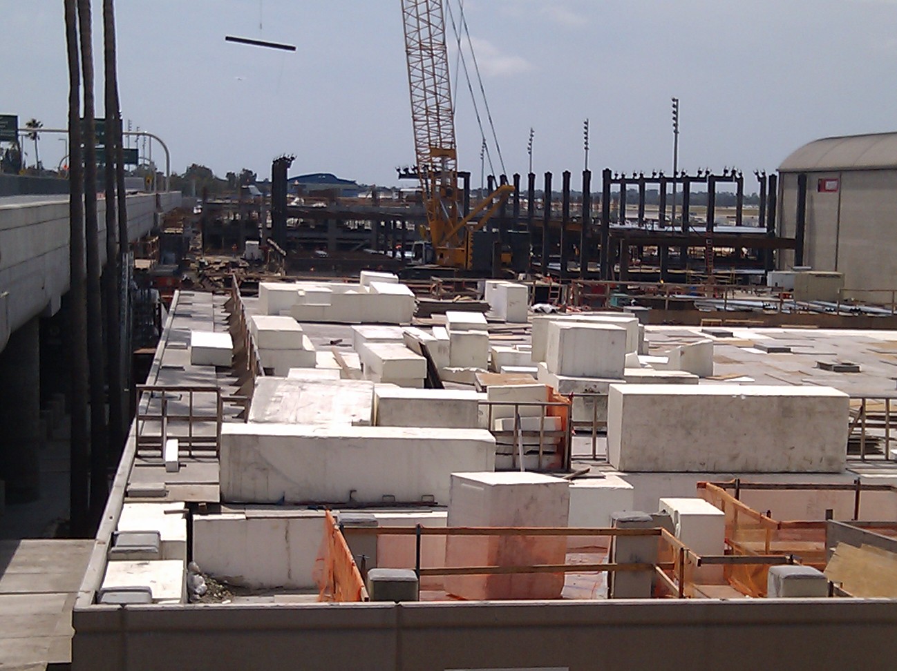
The County of Orange approved the JWA Improvement Program [1] to increase the terminal size and accommodate six additional bridged gates with six commuter slots. An extension to the South of the current Terminal B will house the new bridged passenger boarding gates to be called Terminal C. Three new baggage claim carousels will be built in the arrivals area of Terminal C. A new central plant with power generation and cooling systems will also be part of the improvement project. In order to make room for the new terminal C, existing parking garage B1 was deconstructed and removed in 2009. A replacement parking garage will be constructed along with general improvements to the existing Terminal A and B facilities. The improvements are part of a multi-year program that is to be completed in stages allowing for continual operation and minimal disruption to the airport. Temporary regional jet facilities were added to both the Terminal A and B ground level areas. Both facilities accommodate 2 gate areas and can be used for regional jet and regular commercial aircraft via air stair boarding. Both facilities are accessed from the outside doorway one level below at each end of the terminal. As part of the Airport Improvement Program, permanent commuter holdroom facilities will be constructed creating North and South Commuter holdrooms. Terminals A and B in the Riley Terminal will also be renovated to match the new Terminal C. All jet bridges will be replaced in the existing terminals and a new baggage system will also be introduced. Two gates in the existing terminal will be modified to handle international arrivals requiring Customs and Border Protection Processing (CBP). Flights from Canada go through US CBP processing in Canada however local CBP presence is required for any contingencies, formal CBP processing at John Wayne Airport is to support destinations such as Mexico. Construction of the Improvement Program is underway. The existing Remain-Over-Night location for commercial aircraft has been relocated and is being used as temporary public vehicle parking lot C. The new parking structure C has nearly completed construction and expected to open in late 2010. The new central plant will be operational in late 2010. Terminal C is expected to be completed by Summer 2011 and ready for use in late 2011. Aircraft incidentsOn February 17, 1981, Air California (AirCal) Flight 336 (a Boeing 737-200), flying from San Jose, California to John Wayne Airport, crashed upon initiating a go-around. The crew was cleared for a visual approach to Runway 19R while the controller had cleared another flight to take off from 19R. Upon realizing the mistake, the controller ordered Air California 336 to go around and the other aircraft to abort its takeoff, which it did. The captain of the landing Air California aircraft delayed the go-around then initiated a gear up procedure before a positive rate of climb was achieved, causing the plane to stall. The 737 then banked left at low altitude causing the left wingtip to make contact with the runway. Then the nose came down and struck the ground and the airplane pirouetted and inverted and skidded down the runway before coming to rest in the margin. A fire started, 4 passengers sustained minor injuries, and 91 other passengers and 5 crew exited without incident. The aircraft, registration number N468AC, was damaged beyond repair and was written off. On August 16, 1987, Northwest Airlines Flight 255, (a McDonell-Douglas MD-82) flying from Detroit Metro Airport to John Wayne Airport with an intermediate stop at Phoenix, Arizona, crashed during takeoff from Detroit, killing 154 of 155 passengers and crew on board and 2 persons on the ground. One of the contributing factors in the crash was the crew's concern about arriving at John Wayne Airport before the 11:00 p.m. commercial airline arrival curfew. On December 15, 1993, a chartered IAI Westwind business jet carrying 2 flightcrew members and 3 passengers (including Rich Snyder, president of In-N-Out Burger), crashed while on approach to John Wayne Airport. All five occupants were killed in the crash. The aircraft, which departed Brackett Field, thirty miles to the north in La Verne, California, followed a Boeing 757 for landing, became caught in the 757's wake turbulence, rolled into a deep descent and crashed near the intersection of State Route 55 and Edinger Avenue. The crash investigation led to the FAA requirement for an adequate period between heavy aircraft and following light aircraft to allow wake turbulence to diminish. John Wayne Airport in popular culture
The above content comes from Wikipedia and is published under free licenses – click here to read more.
Runway InformationRunway 01L/19R
Runway 01R/19L
Runway 19X
Radio Navigation Aids
Remarks
Based Aircraft
Major Carriers Serving This Airport
Most Popular Destinations
Most Popular Aircraft
Operational Statistics
John Wayne Airport-orange County Airport Address: Orange County, CA Tel: 949-252-5183 Images
and information placed above are from We thank them for the data!
We don't guarantee the information is fresh and accurate. The data may
be wrong or outdated. |
|||||||||||||||||||||||||||||||||||||||||||||||||||||||||||||||||||||||||||||||||||||||||||||||||||||||||||||||||||||||||||||||||||||||||||||||||||||||||||||||||||||||||||||||||||||||||||||||||||||||||||||||||||||||||||||||||||||||||||||||||||||||||||||||||||||||||||||||||||||||||||||||||||||||||||||||||||||||||||||||||||||||||||||||||||||||||||||||||||||||||||||||||||||||||||||||||||||||||||||||||||||||||||||||||||||||||||||||||||||||||||||||||||||||||||||||||||||||||||||||||||||||||||||||||||||||||||||||||||||||||||||||||||||||||||||||||||||||||||||||||||||||||||||||||||||||||||||||||||||||||||||||||||||||||||||||||||||||||

 |
|
Copyright 2004-2026 © by Airports-Worldwide.com, Vyshenskoho st. 36, Lviv 79010, Ukraine Legal Disclaimer |