 |
|
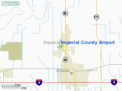
Imperial County Airport
Boley Field |
| IATA: IPL – ICAO: KIPL – FAA LID: IPL |
| Summary |
| Airport type |
Public |
| Operator |
Imperial County |
| Location |
Imperial, California |
| Elevation AMSL |
-56 ft / -17.1 m |
| Coordinates |
32°50′03″N 115°34′43″W / 32.83417°N 115.57861°W / 32.83417; -115.57861Coordinates: 32°50′03″N 115°34′43″W / 32.83417°N 115.57861°W / 32.83417; -115.57861 |
| Runways |
| Direction |
Length |
Surface |
| ft |
m |
| 14/32 |
5,304 |
1,617 |
Asphalt |
| 8/26 |
4,500 |
1,372 |
Asphalt |
Imperial County Airport (IATA: IPL, ICAO: KIPL, FAA LID: IPL), also known as Boley Field, is a public airport located partially in the city of Imperial and partially in an unincorporated area in Imperial County, California, United States. The airport is located 0.94 miles (1.5 km) south of the central business district (CBD) of Imperial. The airport serves nearby communities, including El Centro. The airport covers 429 acres (174 ha) and has two runways. It is mostly used for general aviation, but is served by one commercial airline. Service is subsidized by the Essential Air Service program.
Airline
| Airlines |
Destinations |
| United Express operated by SkyWest Airlines |
Los Angeles, Yuma |
The above content comes from Wikipedia and is published under free licenses – click here to read more.
Location
& QuickFacts
|
FAA
Information Effective: |
2006-09-28 |
|
Airport
Identifier: |
IPL |
|
Longitude/Latitude: |
115-34-43.4800W/32-50-03.1900N
-115.578744/32.834219 (Estimated) |
|
Elevation: |
-54 ft / -16.46 m (Estimated) |
|
Land: |
429 acres |
|
From
nearest city: |
1 nautical miles S of Imperial, CA |
|
Location: |
Imperial County, CA |
|
Magnetic Variation: |
13E (1985) |
Owner
& Manager
|
Ownership: |
Publicly owned |
|
Owner: |
Imperial County |
|
Address: |
County Adm.ctr.940 Main St.
El Centro, CA 92243 |
|
Phone
number: |
760-355-7944 |
|
Manager: |
Bob Philley
STEVE BIRDSALL, DIR OF OPERATIONS (760) 482-4314. |
|
Address: |
1099 Airport Road
Imperial, CA 92251 |
|
Phone number: |
760-355-7944 |
Airport
Operations and Facilities
|
Airport
Use: |
Open to public |
|
Wind
indicator: |
Yes |
|
Segmented
Circle: |
Yes |
|
Control
Tower: |
No |
|
Attendance
Schedule: |
ALL/ALL/0800-1700 |
|
Lighting
Schedule: |
DUSK-DAWN
ACTVT MIRL RYS 08/26 & 14/32 - CTAF. |
|
Beacon
Color: |
Clear-Green (lighted land airport) |
|
Landing
fee charge: |
No
OVERNIGHT TIE-DOWN FEE. |
|
Sectional
chart: |
Phoenix |
|
Region: |
AWP - Western-Pacific |
|
Boundary
ARTCC: |
ZLA - Los Angeles |
|
Tie-in
FSS: |
SAN - San Diego |
|
FSS
on Airport: |
No |
|
FSS
Phone: |
858-277-7043 |
|
FSS
Toll Free: |
1-800-WX-BRIEF |
|
NOTAMs
Facility: |
IPL (NOTAM-d service avaliable) |
|
Certification type/date: |
?? ??/???? |
|
Federal Agreements: |
NGY |
Airport
Communications
|
CTAF: |
122.700 |
|
Unicom: |
122.700 |
Airport
Services
|
Fuel
available: |
100LLA |
|
Airframe
Repair: |
MAJOR |
|
Power
Plant Repair: |
MAJOR |
|
Bottled
Oxygen: |
NONE |
|
Bulk
Oxygen: |
NONE |
|
Runway Information
Runway 08/26
|
Dimension: |
4500 x 75 ft / 1371.6 x 22.9 m |
|
Surface: |
ASPH, Good Condition |
|
Weight
Limit: |
Single wheel: 50000 lbs.
Dual wheel: 50000 lbs. |
|
Edge
Lights: |
Medium |
|
|
Runway 08 |
Runway 26 |
|
Longitude: |
115-35-24.4320W |
115-34-31.6940W |
|
Latitude: |
32-49-55.5590N |
32-49-55.5840N |
|
Alignment: |
90 |
127 |
|
Traffic
Pattern: |
Left |
Right |
|
Markings: |
Basic, Good Condition |
Basic, Good Condition |
|
Crossing
Height: |
38.00 ft |
38.00 ft |
|
VASI: |
2-light PAPI on left side |
4-light PAPI on left side |
|
Visual
Glide Angle: |
3.00� |
3.00� |
|
Obstruction: |
59 ft pline, 1600.0 ft from runway, 23:1 slope
to clear |
32 ft pole, 1575.0 ft from runway, 250 ft right
of centerline, 42:1 slope to clear |
|
Runway 14/32
|
Dimension: |
5304 x 100 ft / 1616.7 x 30.5 m |
|
Surface: |
ASPH, Good Condition |
|
Surface
Treatment: |
Porous Friction Course |
|
Weight
Limit: |
Single wheel: 60000 lbs.
Dual wheel: 80000 lbs.
Dual
tandem wheel: 130000 lbs. |
|
Edge
Lights: |
Medium |
|
|
Runway 14 |
Runway 32 |
|
Longitude: |
115-34-45.4340W |
115-34-16.9190W |
|
Latitude: |
32-50-33.0180N |
32-49-46.3890N |
|
Alignment: |
127 |
127 |
|
Traffic
Pattern: |
Left |
Right |
|
Markings: |
Basic, Good Condition |
Basic, Good Condition |
|
Crossing
Height: |
0.00
ft |
47.00 ft |
|
VASI: |
|
4-box on left side |
|
Visual
Glide Angle: |
0.00� |
3.00� |
|
Runway
End Identifier: |
No |
No |
|
Centerline
Lights: |
No |
No |
|
Touchdown
Lights: |
No |
No |
|
Obstruction: |
9 ft fence, 425.0 ft from runway, 130 ft left
of centerline, 25:1 slope to clear |
15 ft road, 600.0 ft from runway, 150 ft right
of centerline, 26:1 slope to clear |
|
Radio Navigation
Aids
|
ID |
Type |
Name |
Ch |
Freq |
Var |
Dist |
|
NJK |
TACAN |
El Centro |
047X |
|
13E |
5.2 nm |
|
MXL |
VOR/DME |
Mexicali |
097X |
115.00 |
14E |
21.9 nm |
|
IPL |
VORTAC |
Imperial |
106X |
115.90 |
14E |
6.2 nm |
|
BZA |
VORTAC |
Bard |
115X |
116.80 |
14E |
49.5 nm |
Remarks
- AVOID
NAF EL CENTRO TFC; ACFT DEP RWY 26 RIGHT TURN - STAY BELOW 1000'; CTC
NAF TOWER 119.1 FOR ADVISORY.
- FREQUENT
HIGH-SPEED MILITARY JET TRAFFIC TRANSITS IPL TFC AREA WESTBOUND DESCENDING
VFR TO NAF EL CENTRO. AVOID 2500 FT TO 3500 FT MSL NEAR IPL. CONTACT
NAF TWR 119.1 FOR NAVY TFC ADVY.
- FOR
SVC AFTER HRS CALL (760) 353-1375 FEE CHARGED.
- FREQ
DAY & NIGHT REFUELING OF MILITARY HELICOPTERS VCNTY OF RY 26 THR.
- RY
08/26 CLSD DALGT HRS DURG REFUELING OPERATIONS UNLESS CROSSWIND ON RY
14/32 EXCEEDS 12 KNOTS.
- RADIO
ANT +70 FT LCTD ON CTL TWR AT MIDFIELD RY 14/32 AND 500 FT WEST RY CNTRLN.
Based Aircraft
|
Aircraft
based on field: |
86 |
|
Single
Engine Airplanes: |
66 |
|
Multi
Engine Airplanes: |
15 |
|
Helicopters: |
5 |
Major Carriers
Serving This Airport
Most Popular Destinations
| Los Angeles Intl (LAX) |
50.0% |
| San Diego Intl (SAN) |
49.5% |
|
Yuma Mcas/yuma Intl (YUM) |
0.5% |
Most Popular Aircraft
|
N296SW |
6.0% |
| N288SW |
5.4% |
|
N235SW |
4.3% |
| N237SW |
4.3% |
|
N270YV |
3.8% |
| N292UX |
3.8% |
|
N227SW |
3.8% |
| N297SW |
3.8% |
|
N271YV |
3.3% |
| N295SW |
3.3% |
Operational Statistics
|
Aircraft
Operations: |
202/Day |
|
Air Taxi: |
13.4% |
|
General
Aviation Local: |
40.8% |
|
General
Aviation Itinerant: |
43.5% |
|
Military: |
2.4% |
Imperial County Airport
Address:
Imperial County, CA
Tel:
760-355-7944
Images
and information placed above are from
http://www.airport-data.com/airport/IPL/
We
thank them for the data!
| General
Info |
| Country |
United
States |
| State |
CALIFORNIA
|
| FAA ID |
IPL
|
| Latitude |
32-50-03.193N
|
| Longitude |
115-34-43.484W
|
| Elevation |
-55 feet
|
| Near City |
IMPERIAL
|
We don't guarantee the information is fresh and accurate. The data may
be wrong or outdated.
For more up-to-date information please refer to other sources.
|
|


