 |
|
|
|
|
|
Location
& QuickFacts
|
FAA
Information Effective: |
2006-09-28 |
|
Airport
Identifier: |
04CL |
|
Longitude/Latitude: |
116-26-29.0560W/33-04-54.1590N
-116.441404/33.081711 (Estimated) |
|
Elevation: |
2310 ft / 704.09 m (Estimated) |
|
Land: |
35 acres |
|
From
nearest city: |
9 nautical miles E of Julian, CA |
|
Location: |
San Diego County, CA |
|
Magnetic Variation: |
13E (1985) |
Owner
& Manager
|
Ownership: |
Privately owned |
|
Owner: |
John Hunt |
|
Address: |
7106 Grt So Overland Stage Rt
Julian, CA 92036 |
|
Phone
number: |
619-765-1406 |
|
Manager: |
John Hunt |
|
Address: |
7106 Grt So Overland Stage Rt
Julian, CA 92036 |
|
Phone number: |
619-765-1406 |
Airport
Operations and Facilities
|
Airport
Use: |
Private |
|
Wind
indicator: |
Yes
WIND SOCK INSTALLED ON NORTH SIDE OF RWY. |
|
Segmented
Circle: |
Yes |
|
Control
Tower: |
No |
|
Attendance
Schedule: |
ALL/ALL/ALL
MANAGER LIVES ON ARPT. |
|
Landing
fee charge: |
No |
|
Sectional
chart: |
Los Angeles |
|
Region: |
AWP - Western-Pacific |
|
Boundary
ARTCC: |
ZLA - Los Angeles |
|
Tie-in
FSS: |
SAN - San Diego |
|
FSS on Airport: |
No |
|
FSS Phone: |
858-277-7043 |
|
FSS Toll Free: |
1-800-WX-BRIEF |
Airport
Communications
Airport
Services
|
Airframe
Repair: |
NONE |
|
Power
Plant Repair: |
NONE |
|
Runway Information
Runway 08/26
|
Dimension: |
1900 x 100 ft / 579.1 x 30.5 m |
|
Surface: |
GRVL-DIRT, |
|
|
Runway 08 |
Runway 26 |
|
Traffic
Pattern: |
Left |
Left |
|
Displaced
threshold: |
0.00
ft |
600.00 ft |
|
Obstruction: |
|
50 ft pline, 50.0 ft from runway |
|
Radio Navigation
Aids
|
ID |
Type |
Name |
Ch |
Freq |
Var |
Dist |
|
SAN |
FAN MARKER |
Encat |
|
|
15E |
39.7 nm |
|
UN |
NDB |
Tijuana |
|
381.00 |
14E |
44.5 nm |
|
NKX |
TACAN |
Miramar |
033X |
|
15E |
38.2 nm |
|
NJK |
TACAN |
El Centro |
047X |
|
13E |
41.2 nm |
|
NZY |
TACAN |
North Island |
117X |
|
14E |
45.3 nm |
|
NRS |
TACAN |
Imperial Beach |
029X |
|
14E |
45.9 nm |
|
NFG |
TACAN |
Camp Pendleton |
055X |
|
13E |
49.0 nm |
|
NKX |
UHF/NDB |
Miramar |
|
352.00 |
15E |
37.4 nm |
|
TIJ |
VOR/DME |
Tijuana |
112X |
116.50 |
14E |
41.6 nm |
|
JLI |
VORTAC |
Julian |
087X |
114.00 |
15E |
8.1 nm |
|
TRM |
VORTAC |
Thermal |
109X |
116.20 |
13E |
35.7 nm |
|
PGY |
VORTAC |
Poggi |
035X |
109.80 |
14E |
39.2 nm |
|
MZB |
VORTAC |
Mission Bay |
125X |
117.80 |
15E |
43.5 nm |
|
PSP |
VORTAC |
Palm Springs |
102X |
115.50 |
13E |
47.4 nm |
|
SEE |
VOT |
Gillespie Field |
|
110.00 |
|
31.0 nm |
|
SAN |
VOT |
Mount Soledad |
|
109.00 |
|
43.4 nm |
Remarks
- 25FT
WATER TANK N SIDE OF RWY.
- (A30-E)
EAST END RWY CLOSED BECAUSE OF PLINE.
- PVT
USE.
Based Aircraft
|
Aircraft
based on field: |
2 |
|
Single
Engine Airplanes: |
2 |
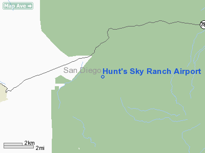
Hunt's Sky Ranch Airport
Address:
San Diego County, CA
Tel:
619-765-1406
Images
and information placed above are from
http://www.airport-data.com/airport/04CL/
We
thank them for the data!
| General
Info |
| Country |
United
States |
| State |
CALIFORNIA
|
| FAA ID |
04CL
|
| Latitude |
33-04-54.159N
|
| Longitude |
116-26-29.056W
|
| Elevation |
2310 feet
|
| Near City |
JULIAN
|
We don't guarantee the information is fresh and accurate. The data may
be wrong or outdated.
For more up-to-date information please refer to other sources.
|
|


