 |
|
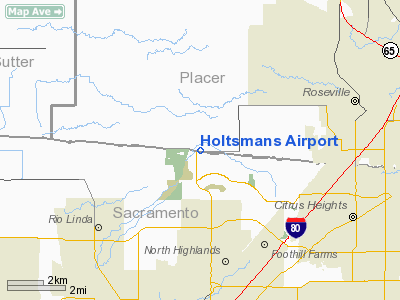
Location
& QuickFacts
|
FAA
Information Effective: |
2006-09-28 |
|
Airport
Identifier: |
CA16 |
|
Longitude/Latitude: |
121-23-21.8290W/38-43-44.6460N
-121.389397/38.729068 (Estimated) |
|
Elevation: |
120 ft / 36.58 m (Estimated) |
|
Land: |
0 acres |
|
From
nearest city: |
3 nautical miles W of Rio Linda, CA |
|
Location: |
Sacramento County, CA |
|
Magnetic Variation: |
16E (1985) |
Owner
& Manager
|
Ownership: |
Privately owned |
|
Owner: |
Clyde Holtsman |
|
Address: |
5765 Pfe Rd
Roseville, CA 95678 |
|
Address: |
|
|
Phone number: |
916-782-6776 |
Airport
Operations and Facilities
|
Airport Use: |
Private |
|
Wind indicator: |
No |
|
Segmented Circle: |
No |
|
Control Tower: |
No |
|
Attendance Schedule: |
UNATNDD |
|
Landing fee charge: |
No |
|
Sectional chart: |
San Francisco |
|
Region: |
AWP - Western-Pacific |
|
Boundary ARTCC: |
ZOA - Oakland |
|
Tie-in FSS: |
RIU - Rancho Murieta |
|
FSS on Airport: |
No |
|
FSS Phone: |
916-354-0161 |
|
FSS Toll Free: |
1-800-WX-BRIEF |
Airport
Services
|
Airframe
Repair: |
NONE |
|
Power
Plant Repair: |
NONE |
|
Runway
Information
Runway N/S
|
Dimension: |
2500 x 200 ft / 762.0 x 61.0 m |
|
Surface: |
TURF, |
|
|
Runway N |
Runway S |
|
Traffic
Pattern: |
Left |
Left |
|
Radio Navigation
Aids
|
ID |
Type |
Name |
Ch |
Freq |
Var |
Dist |
|
MY |
NDB |
Halow |
|
222.00 |
16E |
28.4 nm |
|
OVE |
NDB |
Oroville |
|
212.00 |
16E |
47.3 nm |
|
BAB |
TACAN |
Beale |
023X |
|
16E |
24.5 nm |
|
SUU |
TACAN |
Travis |
113X |
|
17E |
39.1 nm |
|
TZZ |
VOR |
Travis |
|
116.40 |
17E |
30.5 nm |
|
MCC |
VOR/DME |
Mc Clellan |
029X |
109.20 |
17E |
3.8 nm |
|
MYV |
VOR/DME |
Marysville |
045X |
110.80 |
16E |
23.8 nm |
|
HNW |
VOR/DME |
Hangtown |
102X |
115.50 |
17E |
30.0 nm |
|
SAC |
VORTAC |
Sacramento |
099X |
115.20 |
17E |
18.8 nm |
|
ILA |
VORTAC |
Williams |
091X |
114.40 |
18E |
36.2 nm |
|
LIN |
VORTAC |
Linden |
095X |
114.80 |
17E |
43.3 nm |
|
SMF |
VOT |
Sacramento Metropolitan |
|
111.40 |
|
9.7 nm |
|
SAC |
VOT |
Sacramento Executive |
|
111.40 |
|
13.9 nm |
Remarks
- TWO
VERY LARGE OAK TREES E SIDE.
- FIRST
REPORTED 6/19/61. ARPT IS ABOUT 5 NM NE OF MC CLELLAN AFB.
Holtsmans Airport
Address:
Sacramento County, CA
Tel:
916-782-6776
Images
and information placed above are from
http://www.airport-data.com/airport/CA16/
We
thank them for the data!
| General
Info |
| Country |
United
States |
| State |
CALIFORNIA
|
| FAA ID |
CA16
|
| Latitude |
38-43-44.646N
|
| Longitude |
121-23-21.829W
|
| Elevation |
120 feet
|
| Near City |
RIO LINDA
|
We don't guarantee the information is fresh and accurate. The data may
be wrong or outdated.
For more up-to-date information please refer to other sources.
|
|


