|
|
Coordinates: 36°14′53.2″N 120°14′18.5″W / 36.248111°N 120.238472°W / 36.248111; -120.238472
| Harris Ranch Airport |
 |
| IATA: none – ICAO: none – FAA LID: 3O8 |
| Summary |
| Airport type |
Public |
| Owner/Operator |
Harris Ranch Beef Company |
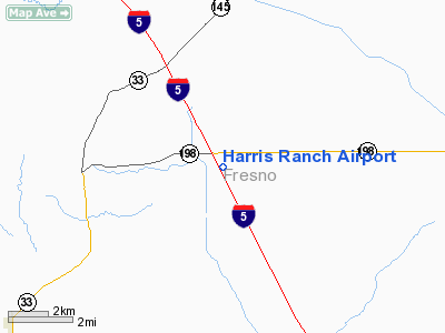
| Location |
Coalinga, California |
| Elevation AMSL |
470 ft / 143 m |
| Coordinates |
36°14′53.2″N 120°14′18.5″W / 36.248111°N 120.238472°W / 36.248111; -120.238472Coordinates: 36°14′53.2″N 120°14′18.5″W / 36.248111°N 120.238472°W / 36.248111; -120.238472 |
| Website |
http://www.harrisranch.com |
| Runways |
| Direction |
Length |
Surface |
| ft |
m |
| 14/32 |
2,820 |
860 |
Asphalt |
|
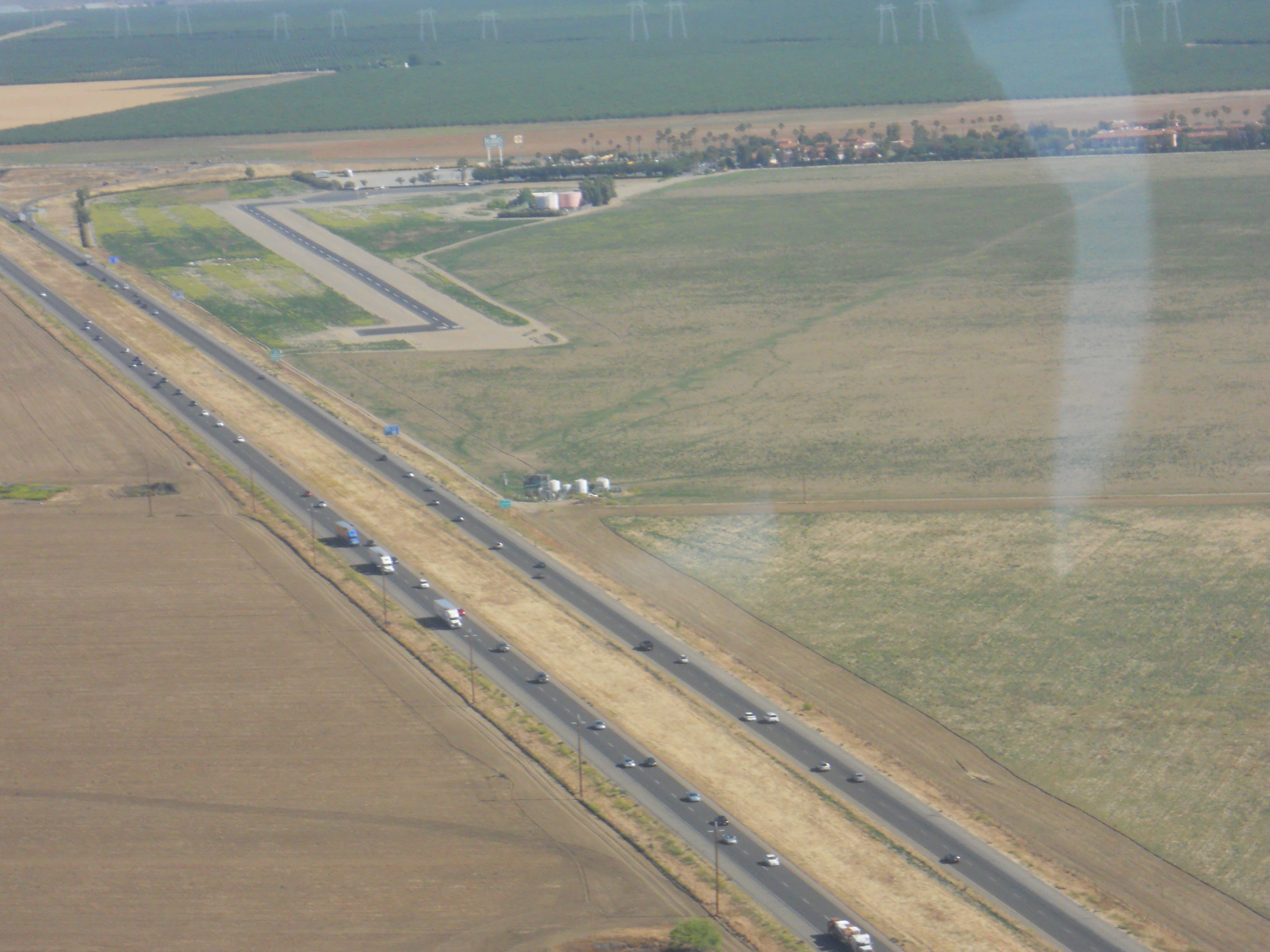
Harris Ranch Airport (FAA LID: 3O8) is an airport near Coalinga, California, next to I-5. To the north of the airport is the Harris Ranch Restaurant and Inn. The airport has been open since March, 1981.
There is only one runway, that is 30 feet wide and 2,820 feet long. Parking and fuel are on the north end near the restaurant. On the south end of the runway is a run-up area. No aircraft are based here.
Uses
There is an average of 27 operations per day here. All 27 were transient General Aviation flights. There are no aircraft based at Harris Ranch.
The above content comes from Wikipedia and is published under free licenses – click here to read more.
Location
& QuickFacts
|
FAA
Information Effective: |
2006-06-08 |
|
Airport
Identifier: |
3O8 |
|
Longitude/Latitude: |
120-14-15.5200W/36-14-52.8270N
-120.237644/36.248007 (Estimated) |
|
Elevation: |
470 ft / 143.26 m (Estimated) |
|
Land: |
80 acres |
|
From
nearest city: |
9 nautical miles NE of Coalinga, CA |
|
Location: |
Fresno County, CA |
|
Magnetic Variation: |
15E (1985) |
Owner
& Manager
|
Ownership: |
Privately owned |
|
Owner: |
Harris Farms |
|
Address: |
Route 1 Box 777
Coalinga, CA 93210 |
|
Phone
number: |
559-935-0717
24 HR PHONE AT OWNERS RESTAURANT 209-935-0717. |
|
Manager: |
Ken Kreyenhagen |
|
Address: |
Route 1 Box 777
Coalinga, CA 93210 |
|
Phone number: |
559-935-0717 |
Airport
Operations and Facilities
|
Airport
Use: |
Open to public |
|
Wind
indicator: |
Yes |
|
Segmented
Circle: |
Yes |
|
Control
Tower: |
No |
|
Attendance
Schedule: |
ALL/ALL/0600-1900 |
|
Lighting
Schedule: |
DUSK-DAWN |
|
Landing
fee charge: |
No |
|
Sectional
chart: |
San Francisco |
|
Region: |
AWP - Western-Pacific |
|
Boundary
ARTCC: |
ZOA - Oakland |
|
Tie-in
FSS: |
RIU - Rancho Murieta |
|
FSS
on Airport: |
No |
|
FSS
Phone: |
916-354-0161 |
|
FSS
Toll Free: |
1-800-WX-BRIEF |
|
NOTAMs
Facility: |
RIU (NOTAM-d service avaliable) |
Airport
Communications
Airport
Services
|
Fuel
available: |
100LL
FUEL AVBL 24 HRS FM SERVICE STATION 559-935-0717. |
|
Runway Information
Runway 14/32
|
Dimension: |
2820 x 30 ft / 859.5 x 9.1 m |
|
Surface: |
ASPH, Fair Condition |
|
Weight
Limit: |
Single wheel: 30000 lbs. |
|
Edge
Lights: |
Low |
|
|
Runway 14 |
Runway 32 |
|
Traffic
Pattern: |
Right |
Left |
|
Markings: |
Basic, Good Condition |
Basic, Good Condition |
|
Obstruction: |
48 ft pole, 1200.0 ft from runway, 30 ft left
of centerline, 20:1 slope to clear |
30 ft pline, 1100.0 ft from runway, 30:1 slope
to clear |
|
Radio Navigation
Aids
|
ID |
Type |
Name |
Ch |
Freq |
Var |
Dist |
|
FCH |
NDB |
Chandler |
|
344.00 |
15E |
34.6 nm |
|
COR |
NDB |
Salyer Farms |
|
205.00 |
16E |
35.7 nm |
|
CUK |
NDB |
Academy |
|
266.00 |
14E |
41.1 nm |
|
HGT |
NDB |
Hunter Liggett |
|
209.00 |
15E |
49.3 nm |
|
NLC |
TACAN |
Lemoore |
080X |
|
16E |
14.4 nm |
|
ROM |
VOR |
Priest |
|
110.00 |
16E |
21.7 nm |
|
VIS |
VOR/DME |
Visalia |
031X |
109.40 |
16E |
37.3 nm |
|
AVE |
VORTAC |
Avenal |
118X |
117.10 |
16E |
38.3 nm |
|
PXN |
VORTAC |
Panoche |
073X |
112.60 |
16E |
38.4 nm |
|
PRB |
VORTAC |
Paso Robles |
090X |
114.30 |
16E |
39.4 nm |
|
CZQ |
VORTAC |
Clovis |
076X |
112.90 |
15E |
43.3 nm |
Remarks
- BE
ALERT ELECTRICAL PLINE 30' AGL TWO TENTHS MILE SOUTH OF ARPT.
- NO
RUN-UPS ON APCH END OF RY 32.
Operational Statistics
|
Aircraft
Operations: |
193/Week |
|
General
Aviation Itinerant: |
100.0% |
Harris Ranch Airport
Address:
Fresno County, CA
Tel:
559-935-0717
Images
and information placed above are from
http://www.airport-data.com/airport/3O8/
We
thank them for the data!
| General
Info |
| Country |
United
States |
| State |
CALIFORNIA
|
| FAA ID |
3O8
|
| Latitude |
36-14-52.827N
|
| Longitude |
120-14-15.520W
|
| Elevation |
470 feet
|
| Near City |
COALINGA
|
We don't guarantee the information is fresh and accurate. The data may
be wrong or outdated.
For more up-to-date information please refer to other sources.
|
|