 |
|
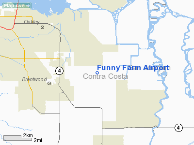
Location
& QuickFacts
|
FAA
Information Effective: |
2006-06-08 |
|
Airport
Identifier: |
4CA2 |
|
Longitude/Latitude: |
121-38-50.8300W/37-56-48.7200N
-121.647453/37.946867 (Estimated) |
|
Elevation: |
29 ft / 8.84 m (Estimated) |
|
Land: |
20 acres |
|
From
nearest city: |
3 nautical miles NE of Brentwood, CA |
|
Location: |
Contra Costa County, CA |
|
Magnetic Variation: |
16E (1995) |
Owner
& Manager
|
Ownership: |
Privately owned |
|
Owner: |
David S. Behne |
|
Address: |
2650 Penny Lane
Brentwood, CA 94513 |
|
Phone
number: |
925-634-8173 |
|
Manager: |
Douglas D. Dods |
|
Address: |
4804 Golden Bear Drive
Antioch, CA 94509 |
|
Phone number: |
925-777-9494 |
Airport
Operations and Facilities
|
Airport
Use: |
Private |
|
Wind
indicator: |
Yes |
|
Segmented
Circle: |
No |
|
Control
Tower: |
No |
|
Attendance
Schedule: |
ALL/ALL/DALGT |
|
Sectional
chart: |
San Francisco |
|
Region: |
AWP - Western-Pacific |
|
Boundary
ARTCC: |
ZOA - Oakland |
|
Tie-in
FSS: |
OAK - Oakland |
|
FSS
Phone: |
510-273-6111 |
|
FSS
Toll Free: |
1-800-WX-BRIEF |
|
Runway Information
Runway 17/35
|
Dimension: |
1880 x 20 ft / 573.0 x 6.1 m |
|
Surface: |
ASPH, |
|
|
Runway 17 |
Runway 35 |
|
Traffic
Pattern: |
Right |
Left |
|
Obstruction: |
50 ft trees, 100.0 ft from runway |
50 ft trees, 100.0 ft from runway |
|
Radio Navigation
Aids
|
ID |
Type |
Name |
Ch |
Freq |
Var |
Dist |
|
LV |
NDB |
Reiga |
|
374.00 |
16E |
15.4 nm |
|
TCY |
NDB |
Tracy |
|
203.00 |
15E |
18.1 nm |
|
SUU |
TACAN |
Travis |
113X |
|
17E |
22.8 nm |
|
NUQ |
TACAN |
Moffett |
123X |
|
17E |
36.6 nm |
|
TZZ |
VOR |
Travis |
|
116.40 |
17E |
25.1 nm |
|
CCR |
VOR/DME |
Concord |
117X |
117.00 |
17E |
19.7 nm |
|
SJC |
VOR/DME |
San Jose |
088X |
114.10 |
16E |
37.2 nm |
|
MOD |
VOR/DME |
Modesto |
093X |
114.60 |
17E |
38.0 nm |
|
SFO |
VOR/DME |
San Francisco |
105X |
115.80 |
17E |
39.7 nm |
|
MCC |
VOR/DME |
Mc Clellan |
029X |
109.20 |
17E |
44.8 nm |
|
ECA |
VORTAC |
Manteca |
107X |
116.00 |
17E |
23.6 nm |
|
SAC |
VORTAC |
Sacramento |
099X |
115.20 |
17E |
30.2 nm |
|
OAK |
VORTAC |
Oakland |
115X |
116.80 |
17E |
30.4 nm |
|
LIN |
VORTAC |
Linden |
095X |
114.80 |
17E |
31.4 nm |
|
SGD |
VORTAC |
Scaggs Island |
058X |
112.10 |
17E |
37.1 nm |
|
SAU |
VORTAC |
Sausalito |
109X |
116.20 |
17E |
41.9 nm |
|
OSI |
VORTAC |
Woodside |
086X |
113.90 |
17E |
44.9 nm |
|
SAC |
VOT |
Sacramento Executive |
|
111.40 |
|
34.8 nm |
|
SFO |
VOT |
San Francisco Intl |
|
111.00 |
|
39.8 nm |
|
SMF |
VOT |
Sacramento Metropolitan |
|
111.40 |
|
44.8 nm |
Remarks
- 100
FT WATER TOWER 2.5 MILES SW OF ARPT.
- PROVIDED
VFR, PRIVATE USE, OBSTRUCTION FREE INGRESS/EGRESS.
Based Aircraft
|
Aircraft
based on field: |
5 |
|
Single
Engine Airplanes: |
5 |
Operational Statistics
|
Aircraft
Operations: |
12/Week |
|
General
Aviation Local: |
83.3% |
|
General
Aviation Itinerant: |
16.7% |
Funny Farm Airport
Address:
Contra Costa County, CA
Tel:
925-634-8173,
925-777-9494
Images
and information placed above are from
http://www.airport-data.com/airport/4CA2/
We
thank them for the data!
| General
Info |
| Country |
United
States |
| State |
CALIFORNIA
|
| FAA ID |
4CA2
|
| Latitude |
37-56-48.720N
|
| Longitude |
121-38-50.830W
|
| Elevation |
29 feet
|
| Near City |
BRENTWOOD
|
We don't guarantee the information is fresh and accurate. The data may
be wrong or outdated.
For more up-to-date information please refer to other sources.
|
|


