 |
|
Location
& QuickFacts
|
FAA
Information Effective: |
2006-06-08 |
|
Airport
Identifier: |
CN38 |
|
Longitude/Latitude: |
121-26-14.8280W/38-20-28.6830N
-121.437452/38.341301 (Estimated) |
|
Elevation: |
19 ft / 5.79 m (Estimated) |
|
Land: |
20 acres |
|
From
nearest city: |
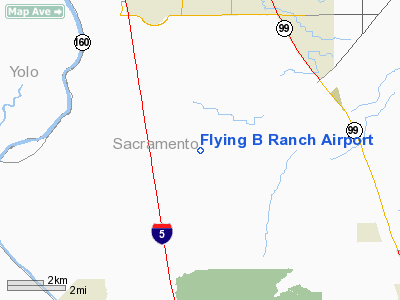
3 nautical miles SE of Franklin, CA |
|
Location: |
Sacramento County, CA |
|
Magnetic Variation: |
16E (1985) |
Owner
& Manager
|
Ownership: |
Privately owned |
|
Owner: |
Joseph L. Herren |
|
Address: |
5751 Point Pleasant Road
Elk Grove, CA 95758 |
|
Phone number: |
916-684-2203 |
|
Address: |
|
Airport
Operations and Facilities
|
Airport Use: |
Private |
|
Wind indicator: |
Yes |
|
Segmented Circle: |
No |
|
Control Tower: |
No |
|
Attendance Schedule: |
UNATNDD |
|
Landing fee charge: |
No |
|
Sectional chart: |
San Francisco |
|
Region: |
AWP - Western-Pacific |
|
Boundary ARTCC: |
ZOA - Oakland |
|
Tie-in FSS: |
RIU - Rancho Murieta |
|
FSS on Airport: |
No |
|
FSS Phone: |
916-354-0161 |
|
FSS Toll Free: |
1-800-WX-BRIEF |
Airport
Services
|
Airframe
Repair: |
NONE |
|
Power
Plant Repair: |
NONE |
|
Runway Information
Runway 14/32
|
Dimension: |
1385 x 50 ft / 422.1 x 15.2 m |
|
Surface: |
TURF, |
|
|
Runway 14 |
Runway 32 |
|
Traffic
Pattern: |
Left |
Left |
|
Obstruction: |
4 ft fence, 40.0 ft from runway |
, 50.0 ft from runway |
|
Radio Navigation
Aids
|
ID |
Type |
Name |
Ch |
Freq |
Var |
Dist |
|
TCY |
NDB |
Tracy |
|
203.00 |
15E |
39.0 nm |
|
LV |
NDB |
Reiga |
|
374.00 |
16E |
40.7 nm |
|
SUU |
TACAN |
Travis |
113X |
|
17E |
24.6 nm |
|
BAB |
TACAN |
Beale |
023X |
|
16E |
47.7 nm |
|
TZZ |
VOR |
Travis |
|
116.40 |
17E |
17.6 nm |
|
MCC |
VOR/DME |
Mc Clellan |
029X |
109.20 |
17E |
19.7 nm |
|
CCR |
VOR/DME |
Concord |
117X |
117.00 |
17E |
33.8 nm |
|
HNW |
VOR/DME |
Hangtown |
102X |
115.50 |
17E |
39.7 nm |
|
MYV |
VOR/DME |
Marysville |
045X |
110.80 |
16E |
46.0 nm |
|
MOD |
VOR/DME |
Modesto |
093X |
114.60 |
17E |
48.6 nm |
|
SAC |
VORTAC |
Sacramento |
099X |
115.20 |
17E |
8.2 nm |
|
LIN |
VORTAC |
Linden |
095X |
114.80 |
17E |
26.0 nm |
|
ECA |
VORTAC |
Manteca |
107X |
116.00 |
17E |
33.0 nm |
|
SGD |
VORTAC |
Scaggs Island |
058X |
112.10 |
17E |
45.2 nm |
|
SAC |
VOT |
Sacramento Executive |
|
111.40 |
|
10.8 nm |
|
SMF |
VOT |
Sacramento Metropolitan |
|
111.40 |
|
22.2 nm |
Remarks
Based Aircraft
|
Aircraft
based on field: |
2 |
|
Single
Engine Airplanes: |
2 |
Flying B Ranch Airport
Address:
Sacramento County, CA
Tel:
916-684-2203
Images
and information placed above are from
http://www.airport-data.com/airport/CN38/
We
thank them for the data!
| General
Info |
| Country |
United
States |
| State |
CALIFORNIA
|
| FAA ID |
CN38
|
| Latitude |
38-20-28.683N
|
| Longitude |
121-26-14.828W
|
| Elevation |
19 feet
|
| Near City |
FRANKLIN
|
We don't guarantee the information is fresh and accurate. The data may
be wrong or outdated.
For more up-to-date information please refer to other sources.
|
|


