|
|
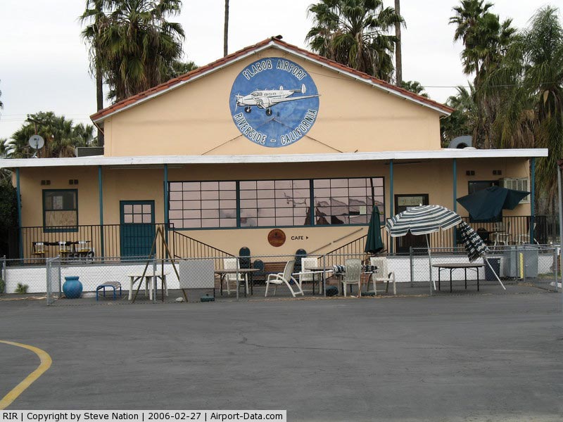
| Flabob Airport |
| IATA: RIR – ICAO: KRIR – FAA LID: RIR |
| Summary |
| Airport type |
Public |
| Owner |
Flabob Inc. 4130 Mennes Ave, Riverside, CA 92509 |
| Serves |
Riverside, California |
| Location |
Rubidoux, California |
| Elevation AMSL |
764 ft / 233 m |
| Coordinates |
33°59′20″N 117°24′36″W / 33.98889°N 117.41°W / 33.98889; -117.41 |
| Website |
www.flabob.com |
| Runways |
| Direction |
Length |
Surface |
| ft |
m |
| 6/24 |
3,200 |
975 |
Asphalt |
| Source: Federal Aviation Administration |
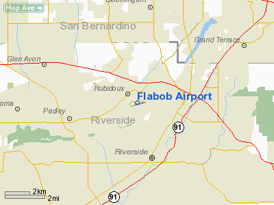
Flabob Airport (IATA: RIR, ICAO: KRIR, FAA LID: RIR) is a small public use airport located three nautical miles (6 km) northwest of the central business district of Riverside, in Riverside County, California, United States. The airport is located in the unincorporated community of Rubidoux, beside the Santa Ana River. Established in 1925 by Flavio Madariaga and Bob Bogan, the name of the airport was derived by combining the first three letters of their names.
Facilities and aircraft
Flabob Airport covers an area of 80 acres (32 ha) at an elevation of 764 feet (233 m) above mean sea level. It has one runway designated 6/24 with an asphalt surface measuring 3,200 by 50 feet (975 x 15 m).
For the 12-month period ending December 31, 2004, the airport had 40,000 general aviation aircraft operations, an average of 109 per day. At that time there were 202 aircraft based at this airport: 94% single-engine and 6% multi-engine.
The above content comes from Wikipedia and is published under free licenses – click here to read more.
|
 |
(Click on the photo to enlarge) |
Location
& QuickFacts
|
FAA
Information Effective: |
2006-06-08 |
|
Airport
Identifier: |
RIR |
|
Longitude/Latitude: |
117-24-38.1650W/33-59-23.0520N
-117.410601/33.989737 (Estimated) |
|
Elevation: |
764 ft / 232.87 m (Estimated) |
|
Land: |
80 acres |
|
From
nearest city: |
3 nautical miles NW of Riverside/rubidoux/,
CA |
|
Location: |
Riverside County, CA |
|
Magnetic Variation: |
14E (1985) |
Owner
& Manager
|
Ownership: |
Privately owned |
|
Owner: |
Flabob Inc |
|
Address: |
4130 Mennes Ave
Riverside, CA 92509 |
|
Phone number: |
951-683-2309 |
|
Manager: |
Leo L Doiron |
|
Address: |
4130 Mennes Ave
Riverside, CA 92509 |
|
Phone number: |
951-683-2309 |
Airport
Operations and Facilities
|
Airport
Use: |
Open to public |
|
Wind
indicator: |
Yes |
|
Segmented
Circle: |
No |
|
Control
Tower: |
No |
|
Attendance
Schedule: |
ALL/MON-FRI/0830-1630 |
|
Lighting
Schedule: |
DUSK-DAWN
ACTVT MIRL RY 06/24 - CTAF. |
|
Landing
fee charge: |
No |
|
Sectional
chart: |
Los Angeles |
|
Region: |
AWP - Western-Pacific |
|
Traffic
Pattern Alt: |
700 ft |
|
Boundary
ARTCC: |
ZLA - Los Angeles |
|
Tie-in
FSS: |
RAL - Riverside |
|
FSS
on Airport: |
No |
|
FSS
Phone: |
951-351-3020 |
|
FSS
Toll Free: |
1-800-WX-BRIEF |
|
NOTAMs
Facility: |
RAL (NOTAM-d service avaliable) |
Airport
Communications
|
CTAF: |
122.800 |
|
Unicom: |
122.800 |
Airport
Services
|
Fuel
available: |
100LL80 |
|
Airframe
Repair: |
MAJOR |
|
Power
Plant Repair: |
MAJOR |
|
Bottled
Oxygen: |
NONE |
|
Bulk
Oxygen: |
NONE |
|
Runway Information
Runway 06/24
|
Dimension: |
3200 x 50 ft / 975.4 x 15.2 m |
|
Surface: |
ASPH, Good Condition |
|
Edge
Lights: |
Non-standard lighting system
RWY 06/24 NSTD MIRL; ONE RED/GREEN LGT EACH SIDE OF THLD. |
|
|
Runway 06 |
Runway 24 |
|
Traffic
Pattern: |
Left |
Left |
|
Markings: |
Basic, Fair Condition |
Basic, Fair Condition |
|
Runway
End Identifier: |
No |
No |
|
Centerline
Lights: |
No |
No |
|
Touchdown
Lights: |
No |
No |
|
Obstruction: |
80 ft trees, 1800.0 ft from runway, 20:1 slope
to clear |
27 ft trees, 700.0 ft from runway, 100 ft right
of centerline, 18:1 slope to clear |
|
Radio Navigation
Aids
|
ID |
Type |
Name |
Ch |
Freq |
Var |
Dist |
|
SB |
NDB |
Petis |
|
397.00 |
14E |
4.6 nm |
|
SJY |
NDB |
San Jacinto |
|
227.00 |
14E |
23.6 nm |
|
EMT |
NDB |
El Monte |
|
359.00 |
15E |
31.5 nm |
|
CPM |
NDB |
Compton |
|
378.00 |
15E |
42.2 nm |
|
RIV |
TACAN |
March |
077X |
|
14E |
8.4 nm |
|
NFG |
TACAN |
Camp Pendleton |
055X |
|
13E |
43.0 nm |
|
RAL |
VOR |
Riverside |
|
112.40 |
15E |
3.0 nm |
|
HDF |
VOR |
Homeland |
|
113.40 |
14E |
17.1 nm |
|
ELB |
VOR/DME |
El Toro |
119X |
117.20 |
14E |
24.7 nm |
|
VCV |
VOR/DME |
Victorville |
031X |
109.40 |
14E |
36.3 nm |
|
PDZ |
VORTAC |
Paradise |
059X |
112.20 |
15E |
7.3 nm |
|
POM |
VORTAC |
Pomona |
041X |
110.40 |
15E |
19.5 nm |
|
SLI |
VORTAC |
Seal Beach |
104X |
115.70 |
15E |
34.5 nm |
|
OCN |
VORTAC |
Oceanside |
100X |
115.30 |
15E |
45.0 nm |
|
PSP |
VORTAC |
Palm Springs |
102X |
115.50 |
13E |
49.4 nm |
|
SNA |
VOT |
Santa Ana |
|
110.00 |
|
29.7 nm |
|
LAX |
VOT |
San Pedro Hill |
|
113.90 |
|
48.5 nm |
Remarks
- MTN
1340 FT MSL 3/4 MILE SE OF ARPT +20 FT CROSS ON TOP.
- DEPARTURES
TO THE SOUTH CTC RIVERSIDE ATCT.
- AVOID
OVR FLT OF TRAILER PARK 1000 FT EAST OF RY 06/24 ON TKOF.
- RY
24 AFT TKOF TURN LEFT 10 DEG; STAY NORTH OF RIVERBED.
- RY
24 CALM WIND RY.
- HELICOPTER
FLIGHT TRAINING PROHIBITED.
- PREDATES
1958 FA ACT.
Based Aircraft
|
Aircraft
based on field: |
202 |
|
Single
Engine Airplanes: |
190 |
|
Multi
Engine Airplanes: |
12 |
Operational Statistics
|
Aircraft
Operations: |
110/Day |
|
General
Aviation Local: |
60.0% |
|
General
Aviation Itinerant: |
40.0% |
Flabob Airport
Address:
Riverside County, CA
Tel:
951-683-230
Images
and information placed above are from
http://www.airport-data.com/airport/RIR/
We
thank them for the data!
| General
Info |
| Country |
United
States |
| State |
CALIFORNIA
|
| FAA ID |
RIR
|
| Latitude |
33-59-23.052N
|
| Longitude |
117-24-38.165W
|
| Elevation |
764 feet
|
| Near City |
RIVERSIDE/RUBIDOUX/
|
We don't guarantee the information is fresh and accurate. The data may
be wrong or outdated.
For more up-to-date information please refer to other sources.
|
|