 |
|
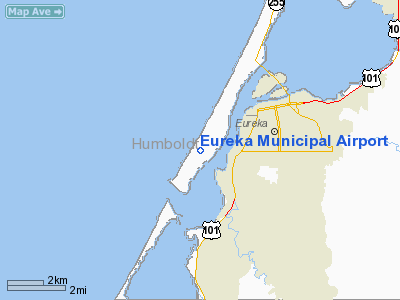
| Eureka Municipal Airport |
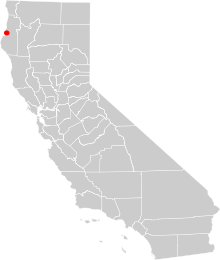 |
| O33's location in California |
| IATA: none – ICAO: none – FAA LID: O33 |
| Summary |
| Airport type |
Public |
| Owner |
City of Eureka |
| Serves |
Eureka, California |
| Elevation AMSL |
20 ft / 6 m |
| Coordinates |
40°46′51″N 124°12′44″W / 40.78083°N 124.21222°W / 40.78083; -124.21222 |
| Runways |
| Direction |
Length |
Surface |
| ft |
m |
| 16/34 |
2,700 |
823 |
Asphalt |
| Statistics (2004) |
| Aircraft operations |
5,000 |
| Based aircraft |
18 |
| Source: Federal Aviation Administration |
Eureka Municipal Airport (FAA LID: O33) is a city-owned, public-use airport located two miles (3 km) west of the central business district of Eureka, a city in Humboldt County, California, United States. The airport is on the northern peninsula of Humboldt Bay. Facilities and aircraft
Eureka Municipal Airport covers an area of 657 acres (266 ha) and is approximately 20 ft (6.1 m). above mean sea level (MSL). It has one runway, 16/34, with a 2,700 x 60 ft (823 x 18 m) asphalt surface. It is used entirely for general aviation purposes; 60% of traffic being local and 40% being transient. For the 12-month period ending December 3, 2004, the airport had 5,000 aircraft operations, an average of 13 per day. At that time there were 18 aircraft based at this airport: 89% single-engine and 11% ultralight.
Other local airports
- Arcata-Eureka Airport
- Kneeland Airport - located ten miles (16 km) southeast of Eureka
- Murray Field - located in Eureka
The above content comes from Wikipedia and is published under free licenses – click here to read more.
Location
& QuickFacts
|
FAA
Information Effective: |
2006-06-08 |
|
Airport
Identifier: |
O33 |
|
Longitude/Latitude: |
124-12-44.2240W/40-46-51.4520N
-124.212284/40.780959 (Estimated) |
|
Elevation: |
20 ft / 6.10 m (Estimated) |
|
Land: |
657 acres |
|
From
nearest city: |
2 nautical miles W of Eureka, CA |
|
Location: |
Humboldt County, CA |
|
Magnetic Variation: |
17E (1985) |
Owner
& Manager
|
Ownership: |
Publicly owned |
|
Owner: |
City Of Eureka |
|
Address: |
531 K St
Eureka, CA 95501 |
|
Phone
number: |
707-444-9691
DIRECTOR OFFICE, EUREKA CITY HALL. |
|
Manager: |
Michael Zoppo |
|
Address: |
531 K St
Eureka, CA 95501-1146 |
|
Phone number: |
707-441-4186 |
Airport
Operations and Facilities
|
Airport
Use: |
Open to public |
|
Wind
indicator: |
Yes |
|
Segmented
Circle: |
Yes |
|
Control
Tower: |
No |
|
Attendance
Schedule: |
UNATNDD |
|
Landing
fee charge: |
No |
|
Sectional
chart: |
Klamath Falls |
|
Region: |
AWP - Western-Pacific |
|
Traffic
Pattern Alt: |
800 ft |
|
Boundary
ARTCC: |
ZSE - Seattle |
|
Tie-in
FSS: |
OAK - Oakland |
|
FSS
on Airport: |
No |
|
FSS
Phone: |
510-273-6111 |
|
FSS
Toll Free: |
1-800-WX-BRIEF |
|
NOTAMs
Facility: |
OAK (NOTAM-d service avaliable) |
|
Federal Agreements: |
PRY |
Airport
Communications
Airport
Services
|
Airframe
Repair: |
NONE |
|
Power
Plant Repair: |
NONE |
|
Bottled
Oxygen: |
NONE |
|
Bulk
Oxygen: |
NONE |
|
Runway Information
Runway 16/34
|
Dimension: |
2700 x 60 ft / 823.0 x 18.3 m |
|
Surface: |
ASPH, Fair Condition |
|
Weight
Limit: |
Single wheel: 10000 lbs. |
|
|
Runway 16 |
Runway 34 |
|
Elevation: |
20.00 ft |
9.00 ft |
|
Traffic
Pattern: |
Right |
Left |
|
Markings: |
Basic, Fair Condition |
Basic, Fair Condition |
|
Runway
End Identifier: |
No |
No |
|
Centerline
Lights: |
No |
No |
|
Touchdown
Lights: |
No |
No |
|
Radio Navigation
Aids
|
ID |
Type |
Name |
Ch |
Freq |
Var |
Dist |
|
ACV |
VOR/DME |
Arcata |
039X |
110.20 |
17E |
12.9 nm |
|
FOT |
VORTAC |
Fortuna |
087X |
114.00 |
19E |
6.7 nm |
Remarks
- DAY
USE ONLY; CLSD NGTS.
- ESTABD
PRIOR TO 1959.
Based Aircraft
|
Aircraft
based on field: |
18 |
|
Single
Engine Airplanes: |
16 |
|
Ultralights: |
2
ULTRALIGHT ACTIVITY ON & INVOF ARPT. |
Operational Statistics
|
Aircraft
Operations: |
97/Week |
|
General
Aviation Local: |
60.0% |
|
General
Aviation Itinerant: |
40.0% |
Eureka Municipal Airport
Address:
Humboldt County, CA
Tel:
707-444-9691, 707-441-4186
Images
and information placed above are from
http://www.airport-data.com/airport/O33/
We
thank them for the data!
| General
Info |
| Country |
United
States |
| State |
CALIFORNIA
|
| FAA ID |
O33
|
| Latitude |
40-46-51.452N
|
| Longitude |
124-12-44.224W
|
| Elevation |
20 feet
|
| Near City |
EUREKA
|
We don't guarantee the information is fresh and accurate. The data may
be wrong or outdated.
For more up-to-date information please refer to other sources.
|
|


