|
|
| El Monte Airport |
 |
| IATA: EMT – ICAO: KEMT – FAA LID: EMT |
| Summary |
| Airport type |
County of Los Angeles |
| Operator |
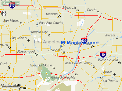
El Monte, California |
| Location |
296 |
| Elevation AMSL |
90.2 ft / m |
| Coordinates |
34°05′10″N 118°02′05″W / 34.08611°N 118.03472°W / 34.08611; -118.03472Coordinates: 34°05′10″N 118°02′05″W / 34.08611°N 118.03472°W / 34.08611; -118.03472 |
| Runways |
| Direction |
Length |
Surface |
| ft |
m |
| 1/19 |
3,995 |
1,218 |
Asphalt |
El Monte Airport (IATA: EMT, ICAO: KEMT, FAA LID: EMT) is a public airport located one mile (1.6 km) north of the central business district (CBD) of El Monte, a city in Los Angeles County, California, USA. The airport covers 103 acres (42 ha) and has one runway.
The above content comes from Wikipedia and is published under free licenses – click here to read more.
Location
& QuickFacts
|
FAA
Information Effective: |
2006-06-08 |
|
Airport
Identifier: |
EMT |
|
Longitude/Latitude: |
118-02-05.4430W/34-05-09.6320N
-118.034845/34.086009 (Estimated) |
|
Elevation: |
296 ft / 90.22 m (Surveyed) |
|
Land: |
103 acres |
|
From
nearest city: |
1 nautical miles N of El Monte, CA |
|
Location: |
Los Angeles County, CA |
|
Magnetic Variation: |
14E (1985) |
Owner
& Manager
|
Ownership: |
Publicly owned |
|
Owner: |
Co Of Los Angeles |
|
Address: |
P O Box 1460
Alhambra, CA 91802-1460 |
|
Phone
number: |
(626) 300-46 |
|
Manager: |
Rafael Herrera |
|
Address: |
4233 North Santa Anita Ave
El Monte, CA 91731 |
|
Phone number: |
626-448-6129 |
Airport
Operations and Facilities
|
Airport
Use: |
Open to public |
|
Wind
indicator: |
Yes |
|
Segmented
Circle: |
Yes |
|
Control
Tower: |
Yes |
|
Attendance
Schedule: |
ALL/ALL/ALL |
|
Lighting
Schedule: |
DUSK-DAWN
WHEN ATCT CLSD ACTVT MIRL RY 01/19, REIL RY 19, PAPI RYS
01 AND 19 - CTAF. |
|
Beacon
Color: |
Clear-Green (lighted land airport) |
|
Landing
fee charge: |
No |
|
Sectional
chart: |
Los Angeles |
|
Region: |
AWP - Western-Pacific |
|
Traffic
Pattern Alt: |
1000 ft |
|
Boundary
ARTCC: |
ZLA - Los Angeles |
|
Tie-in
FSS: |
RAL - Riverside |
|
FSS
on Airport: |
No |
|
FSS
Phone: |
951-351-3020 |
|
FSS
Toll Free: |
1-800-WX-BRIEF |
|
NOTAMs
Facility: |
EMT (NOTAM-d service avaliable) |
|
Federal Agreements: |
NGY |
Airport
Communications
|
CTAF: |
121.200 |
|
Unicom: |
122.950 |
Airport
Services
|
Fuel
available: |
100LLA |
|
Airframe
Repair: |
MAJOR |
|
Power
Plant Repair: |
MAJOR |
|
Bulk
Oxygen: |
NONE |
|
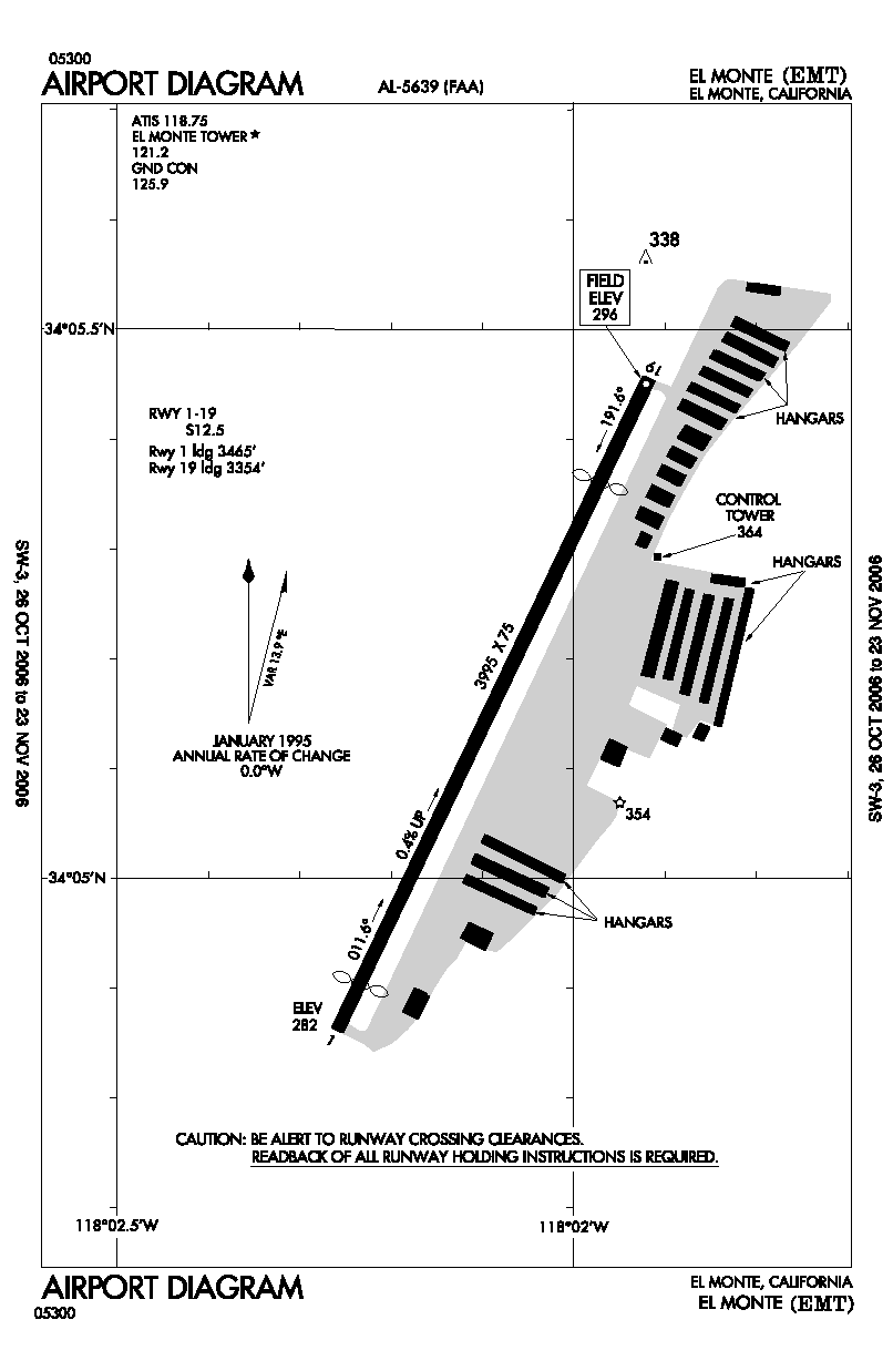
Runway Information
Runway 01/19
|
Dimension: |
3995 x 75 ft / 1217.7 x 22.9 m |
|
Surface: |
ASPH, Good Condition |
|
Surface
Treatment: |
Aggregate Friction Seal Coat |
|
Weight
Limit: |
Single wheel: 12500 lbs. |
|
Edge
Lights: |
Medium |
|
|
Runway 01 |
Runway 19 |
|
Longitude: |
118-02-15.6240W |
118-01-55.2290W |
|
Latitude: |
34-04-51.7510N |
34-05-27.4420N |
|
Elevation: |
282.00 ft |
296.00 ft |
|
Alignment: |
25 |
127 |
|
Traffic
Pattern: |
Left |
Right |
|
Markings: |
Basic, Good Condition |
Basic, Good Condition |
|
Crossing
Height: |
64.00 ft |
37.00 ft |
|
Displaced
threshold: |
290.00 ft |
641.00 ft |
|
VASI: |
2-light PAPI on left side |
2-light PAPI on right side |
|
Visual
Glide Angle: |
4.57� |
4.50� |
|
Runway
End Identifier: |
No |
Yes |
|
Centerline
Lights: |
No |
No |
|
Touchdown
Lights: |
No |
No |
|
Obstruction: |
18 ft pole, 350.0 ft from runway, 85 ft right
of centerline, 8:1 slope to clear
APCH RATIO 35:1 TO DSPLCD THR; APCH RATIO 33:1 TO DSPLCD THR
OVER +45' PLINE OB 1490' FM DSPLCD THR.
RWY 01 +6 FT FENCE 120 FT R OF CNTRLN; +6 FT FENCE 120 FT
LEFT & PARALLEL TO CNTRLN 0-200 FT FM END OF RY. |
30 ft pole, 800.0 ft from runway, 205 ft left
of centerline, 20:1 slope to clear
APCH RATIO 48:1 TO DSPLCD THR.
+2 FT FENCE 75 FT RIGHT OF CNTRLN AT THR TO 0 FT RIGHT OF
CNTRLN AT 200 FT. |
|
Decleard
distances: |
Take off run available 3504.00 ft
Take off distance available 3995.00 ft
Actual stop distance available 3755.00 ft
Landing distance available 3465.00 ft |
Take off run available 3995.00 ft
Take off distance available 3995.00 ft
Actual stop distance available 3995.00 ft
Landing distance available 3354.00 ft |
|
Radio Navigation
Aids
|
ID |
Type |
Name |
Ch |
Freq |
Var |
Dist |
|
EMT |
NDB |
El Monte |
|
359.00 |
15E |
0.2 nm |
|
CPM |
NDB |
Compton |
|
378.00 |
15E |
15.9 nm |
|
PAI |
NDB |
Pacoima |
|
370.00 |
15E |
21.5 nm |
|
SB |
NDB |
Petis |
|
397.00 |
14E |
33.3 nm |
|
GWF |
NDB |
Gen William J Fox |
|
282.00 |
15E |
40.3 nm |
|
RIV |
TACAN |
March |
077X |
|
14E |
39.4 nm |
|
RAL |
VOR |
Riverside |
|
112.40 |
15E |
30.3 nm |
|
HDF |
VOR |
Homeland |
|
113.40 |
14E |
46.3 nm |
|
SMO |
VOR/DME |
Santa Monica |
045X |
110.80 |
15E |
21.5 nm |
|
VNY |
VOR/DME |
Van Nuys |
078X |
113.10 |
15E |
24.2 nm |
|
ELB |
VOR/DME |
El Toro |
119X |
117.20 |
14E |
28.9 nm |
|
VCV |
VOR/DME |
Victorville |
031X |
109.40 |
14E |
44.2 nm |
|
POM |
VORTAC |
Pomona |
041X |
110.40 |
15E |
12.3 nm |
|
SLI |
VORTAC |
Seal Beach |
104X |
115.70 |
15E |
18.2 nm |
|
LAX |
VORTAC |
Los Angeles |
083X |
113.60 |
15E |
21.8 nm |
|
PDZ |
VORTAC |
Paradise |
059X |
112.20 |
15E |
27.1 nm |
|
PMD |
VORTAC |
Palmdale |
092X |
114.50 |
15E |
32.8 nm |
|
LHS |
VORTAC |
Lake Hughes |
021X |
108.40 |
15E |
44.8 nm |
|
FIM |
VORTAC |
Fillmore |
072X |
112.50 |
15E |
45.1 nm |
|
SXC |
VORTAC |
Santa Catalina |
051X |
111.40 |
15E |
46.9 nm |
|
LAX |
VOT |
San Pedro Hill |
|
113.90 |
|
25.4 nm |
|
SNA |
VOT |
Santa Ana |
|
110.00 |
|
25.9 nm |
Remarks
- REMAIN
OVER PAVED CHANNEL ON CLIMB OUT TO SOUTH AND TO NORTH.
- HEAVY
BIRD ACTIVITY ON & INVOF ARPT.
- LGTD
WATER TWR 1 MI W-SW OF ARPT.
Based Aircraft
|
Aircraft
based on field: |
335 |
|
Single
Engine Airplanes: |
306 |
|
Multi
Engine Airplanes: |
20 |
|
Jet Engine
Airplanes: |
2 |
|
Helicopters: |
5 |
|
Gliders: |
2 |
Operational Statistics
|
Aircraft
Operations: |
392/Day |
|
Air Taxi: |
0.0% |
|
General
Aviation Local: |
49.2% |
|
General
Aviation Itinerant: |
50.8% |
|
Military: |
0.1% |
El Monte Airport
Address:
Los Angeles County, CA
Tel:
626-300-46,
626-448-6129
Images
and information placed above are from
http://www.airport-data.com/airport/EMT/
We
thank them for the data!
| General
Info |
| Country |
United
States |
| State |
CALIFORNIA
|
| FAA ID |
EMT
|
| Latitude |
34-05-09.632N
|
| Longitude |
118-02-05.443W
|
| Elevation |
296 feet
|
| Near City |
EL MONTE
|
We don't guarantee the information is fresh and accurate. The data may
be wrong or outdated.
For more up-to-date information please refer to other sources.
|
|